
Status and Trends of Chemicals (excluding metals, PAHs, PCBs and PBDEs) in Water, Biota and Sediment
The majority of other chemicals not assessed at regional sea scale are below concentrations likely to have impacts on the environment or human health. Some pesticides that are banned are showing decreasing trends; however other pesticides require further assessment across the UK. Tributyltin remains a risk in the environment, however imposex is decreasing in four of five areas of the UK.
Background
Two additional data sources have been used to provide a wider assessment of the status of chemicals in coastal waters. These are
-
Data taken from assessments of chemicals in water considered under Water Framework Directive Regulations (WFDR) from England, Northern Ireland, Scotland and Wales and,
-
Data of chemicals in sediment and biota collated by OSPAR that have too short timescales to be included in the regional assessment, but can be used in a more descriptive analysis
Further information
Further details of these chemical sources, transport, impact and measures can be found at Annex C of the Welsh Planning Overview, River Basin Management Plan (2022) and at individual challenges for the water environment 2021 reports for England for Polycyclic aromatic hydrocarbons (PAHs) ; Polybrominated diphenyl ethers (PBDEs); Cypermethrin; Perfluorooctane sulfonate (PFOS), and Mercury.
Assessment method
The 2 data sources have been assessed as follows:
-
Data from WFDR has been collated from the most recent waterbody classification results. Common standards exist across England, Northern Ireland, Scotland and Wales, however the way in which they have been applied may differ. Please refer to the methodology used by each administration for detail.
-
Data collated as part of the OSPAR assessment process in sediment and biota for chemicals that do not have sufficient evidence to be considered for regional assessment. 2 assessments have been carried out:
-
‘Status’ assessment of the significance of the (risk of) pollution, defined as the status where chemicals are at a hazardous level, usually requires assessment criteria that take account of the possible severity of the impacts and hence require criteria that take account of the natural conditions, as background assessment concentrations (BAC); and concentrations that are likely to have an impact on species or human health or as Environmental Quality Standard (EQS). Please refer to assessment criteria in biota and assessment criteria in sediment for further information on the standards used in status assessments.
-
‘Trend assessment’ at each site to focus on changes on temporal scales – provides information about the rates of change. The assessment is only made for sites that have sufficient data.
Results are not presented at a regional sea scale as there is not sufficient data to draw accurate conclusions.
Results
The compliance for chemicals assessed in water for the WFDR is presented in Figure 1. 59 chemicals, or groups of chemicals, have been assessed. The maximum number of water bodies assessed was 66 for hexochlorobenzene and the minimum was 3. All waterbodies pass, except for the 5 chemicals shown in more detail in Table 1.
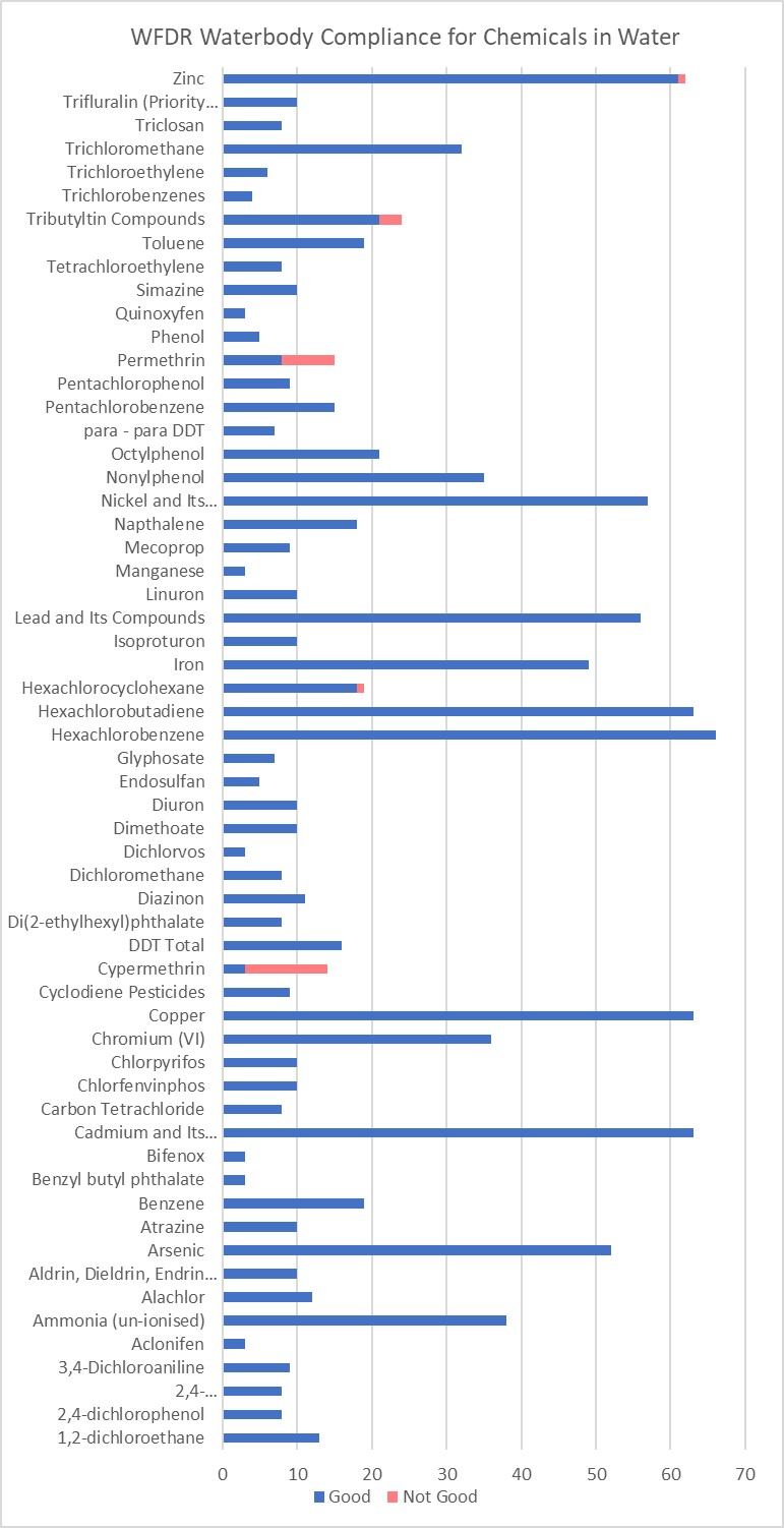
Figure 1: WFDR waterbody compliance for chemicals in water.
Table 1. Chemicals assessed that have 1 or more waterbody failure.
Conclusions
The majority of wider chemicals in water, sediment and biota do not exceed environmental quality standards and do not pose a risk to biodiversity or human health. This demonstrates that for the chemicals considered the current controls are largely sufficient to protect the environment. Whilst some banned pesticides are showing downward trends due to source control, further investigation and potential controls are required for cypermethrin and permethrin in coastal waters. Tributyltin exceeds environmental quality standards in water, sediment and biota but the results from the imposex indicator assessment suggests that was not at a level that was causing significant harm in four out of the five biogeographic regions assessed.
Knowledge gaps
The assessment of wider chemicals includes those that are already considered under OSPAR or WFDR however there is an ever-growing list of chemicals that are considered emerging. These include pharmaceuticals, a wider range of PFAS chemicals and pesticides; however, some of these chemicals do not currently have formal EQS but are being considered for further regulation based on current evidence and research. The Environment Agency are currently considering broadening out the participation in their Priority and Early Warning System (PEWS) to the other UK administrations to broaden the evidence base and promote consistency in risk assessment of emerging chemicals. Those that pose a risk will then be considered for regulation in WFDR or within OSPAR and maybe considered for future UK Marine Strategy Assessments.
Whilst source control is most effective for limiting chemicals in the environment, the impact of climate change on the existing status and trends of chemicals is developing but requires further significant research so we can understand risks.
The effects of mixtures of chemicals and inter-pressure effects on ecosystems (such as chemicals plus excess nutrients) is better understood but has yet to be considered in assessment.
References
Cypermethrin: challenges for the water environment (2021) (available at https://www.gov.uk/government/publications/cypermethrin-challenges-for-the-water-environment)
Polybrominated diphenyl ethers (PBDEs): challenges for the water environment (2021). (available at https://www.gov.uk/government/publications/polybrominated-diphenyl-ethers-pbdes-challenges-for-the-water-environment )
Polycyclic aromatic hydrocarbons (PAHs): challenges for the water environment (2021). (available at https://www.gov.uk/government/publications/polycyclic-aromatic-hydrocarbons-pahs-challenges-for-the-water-environment)
Perfluorooctane sulfonate (PFOS): challenges for the water environment (2021). (available at https://www.gov.uk/government/publications/perfluorooctane-sulfonate-pfos-challenges-for-the-water-environment)
Mercury: challenges for the water environment (2021). (available at https://www.gov.uk/government/publications/perfluorooctane-sulfonate-pfos-challenges-for-the-water-environment)
Natural Resources Wales 2022. River Basin Management Plan Overview Annex Wales. https://cdn.cyfoethnaturiol.cymru/695980/wales-rbmp-overview-annex-2021-2027.pdf
Authors
Mark Charlesworth1 , Rob Fryer2, Manuel Nicolaus3
1National Resources Wales,
2Marine Directorate of the Scottish Government,
3Centre for Environment, Fisheries and Aquaculture Science
Assessment metadata
| Assessment Type | contaminants in coastal waters |
|---|---|
D8 Contaminants | |
| Point of contact email | marinestrategy@defra.gov.uk |
| Metadata date | Sunday, June 1, 2025 |
| Title | Concentration of contaminants in the water column in coastal waters |
| Resource abstract | |
| Linkage | |
| Conditions applying to access and use | © Crown copyright, licenced under the Open Government Licence (OGL). |
| Assessment Lineage | |
| Dataset metadata | |
| Dataset DOI | Scottish Government, Environment Agency, Natural Resources Wales, Scottish Environment Protection Agency (SEPA), Department of Agriculture, Environment and Rural Affairs (DAERA). 2025. 2025 UK Marine Strategy Assessment - Descriptor 8 - contaminants in water. https://doi.org/10.7489/12544-1. |
The Metadata are “data about the content, quality, condition, and other characteristics of data” (FGDC Content Standard for Digital Geospatial Metadata Workbook, Ver 2.0, May 1, 2000).
Metadata definitions
Assessment Lineage - description of data sets and method used to obtain the results of the assessment
Dataset – The datasets included in the assessment should be accessible, and reflect the exact copies or versions of the data used in the assessment. This means that if extracts from existing data were modified, filtered, or otherwise altered, then the modified data should be separately accessible, and described by metadata (acknowledging the originators of the raw data).
Dataset metadata – information on the data sources and characteristics of data sets used in the assessment (MEDIN and INSPIRE compliance).
Digital Object Identifier (DOI) – a persistent identifier to provide a link to a dataset (or other resource) on digital networks. Please note that persistent identifiers can be created/minted, even if a dataset is not directly available online.
Indicator assessment metadata – data and information about the content, quality, condition, and other characteristics of an indicator assessment.
MEDIN discovery metadata - a list of standardized information that accompanies a marine dataset and allows other people to find out what the dataset contains, where it was collected and how they can get hold of it.