
Introduction to UK Marine Strategy
The UK Marine Strategy Regulations 2010 require the UK to take the necessary measures to achieve or maintain Good Environmental Status (GES) through the development and implementation of the UK Marine Strategy (UKMS). This sets out the combined commitments of the four UK governments to work together to monitor and protect some of the most biologically diverse and productive seas in Europe.
The UK Marine Strategy framework consists of a 3-part cycle, which renews very 6 years, for achieving good environmental status (GES) in our seas. Achieving GES is about balancing the protection, restoration, and recovery of the marine environment with ongoing and sustainable use of marine resources, all of which are essential components of a vibrant marine economy. The strategy covers 11 elements (known as descriptors) including: biodiversity; non-indigenous species; commercially exploited fish and shellfish; food webs; eutrophication; sea-floor integrity; hydrographical conditions; contaminants; contaminants in seafood; marine litter and underwater noise.
Publications of the UK Marine Strategy Part One (assessments), Part Two (monitoring) and Part Three (measures) since 2012 marked a significant step forward in the protection and management of UK seas. The approach we take to the UKMS is assimilated into UK law following our departure from the European Union. Its retention demonstrates the combined commitments of the four UK Administrations to work together to protect what are some of the most biologically diverse and productive seas in Europe.
Many of the pressures our seas face and the species found in our waters are transboundary. We work collectively with the other contracting parties to the Oslo and Paris Convention for the protection of the Northeast Atlantic (OSPAR) to understand the impact of these pressures and species. We have considered the OSPAR Quality Status Reports 2023 (QSR) findings in our UK-specific assessments, where relevant to do so. The QSR is a comprehensive assessment of the marine environment in the North-East Atlantic and uses data reported by all 16 Contracting Parties to the OSPAR Convention. This approach is an efficient way to present a picture for our shared sea areas, alongside issues that are more particular to our waters. Where we have used specific assessments for the UK or additional indicators over and above the OSPAR assessments this has been made clear.
This Marine Online Assessment Tool makes the scientific evidence underpinning the UKMS Part One assessments readily available and easily accessible to all.
We are now into the third assessment cycle (UKMS part one), which provides an opportunity to show the progress we have made towards our shared vision since the first assessment in 2012. These updated assessments will help us determine what further action is necessary to achieve GES, and to re-affirm our commitment to work together as the United Kingdom to protect our seas while respecting our national priorities and responsibilities.
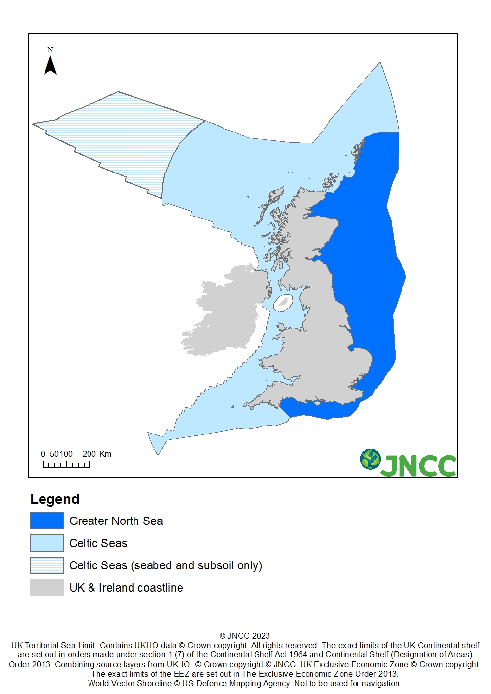
Geographic scope
The UK Marine Strategy covers the extent of the marine waters over which the UK exercises jurisdiction. This area extends from the landward boundary of coastal waters which is equivalent to Mean High Water Springs to the outer limit of the UK Exclusive Economic Zone (EEZ). It also includes the seabed in the area of the continental shelf beyond the EEZ over which the UK exercises jurisdiction on the basis of a submission to the Commission on the limits of the continental shelf. The waters to the west of the UK comprise part of the Celtic Seas sub-region, and waters to the east of the UK, including the Channel, form part of the Greater North Sea sub-region. These sub-regions and the area of UK waters over which the UK Marine Strategy applies is shown in Figure 1.
Figure 1: The area of UK waters to which the UK Marine Strategy applies, and the relevant MSFD sub-regions.
Monitoring and Assessment
The monitoring and assessment work for the various indicators were carried out by experts and scientists working in the UK Marine Monitoring and Assessment Strategy (UKMMAS) Evidence Groups which were coordinated and guided by the UK Monitoring and Assessment Reporting Group (MARG).