Condition of intertidal saltmarsh communities in coastal waters determined using Water Framework Directive methods
The targets covering the area of intertidal saltmarsh communities at an acceptable condition has largely been achieved in the Celtic Seas Marine Strategy Framework Directive sub-region but has not been met for the Greater North Sea. There is low confidence in the assessment results.
Background
UK target on intertidal saltmarsh quality
This indicator is used to assess progress against the Water Framework Directive (European Commission, 2000) ecological status boundaries and areas of unacceptable impact, which are components of the Marine Strategy Framework Directive sediment habitats targets, set in the UK Marine Strategy Part One (HM Government, 2012).
Key pressures and impacts
The saltmarsh index is designed primarily to detect impacts from hydromorphological pressures such as those that alter a water body’s physical structure and flow characteristics that arise from activities such as sediment transport, navigation, flood protection, and to a lesser extent, increased nutrient concentrations (eutrophication).
The UK Water Framework Directive risk assessments identify those pressures that are likely to cause a failure for a Water Framework Directive water body to meet its environmental objectives.
Measures taken to address the impacts
Measures to protect benthic habitats are set out in the UK Marine Strategy Part Three (HM Government, 2015). These include those related to the Habitats Directive (European Commission, 1992), Water Framework Directive (European Commission, 2000), Urban Wastewater Treatment Directive (European Commission, 1991a), Nitrates Directive (European Commission, 1991b), OSPAR convention, Marine Spatial Planning, land management schemes, catchment sensitive farming, and European Marine Site management schemes.
Monitoring, assessment and regional co-operation
Areas that have been assessed
Progress against the UK target was assessed for the Celtic Seas and the Greater North Sea Marine Strategy Framework Directive sub-regions and their constituent UK Regional Seas set out in Charting Progress 2 (UKMMAS, 2010).
Monitoring and assessment methods
Routine monitoring of saltmarsh is undertaken for Water Framework Directive, Habitats Directive, and Site of Special Scientific Interest site assessment. The Water Framework Directive saltmarsh index is based on saltmarsh extent (current proportion of historical extent and extent change), proportions of zones present, dominant zone extent as a proportion of the total extent and taxa number as a proportion of a historical reference. These measurements are combined to derive an Ecological Quality Ratio.
Assessment thresholds
The indicator quality threshold is defined as the boundary for Water Framework Directive Good Ecological Status (Ecological Quality Ratio ≥0.60) or Good Ecological Potential (for Heavily Modified Water Bodies). For Marine Strategy Framework Directive sub-region and UK Regional Sea assessments, the overall indicator target is met where the assessed surface area meeting the quality threshold exceeds the quantity threshold of 95%.
Regional co-operation
The indicator has not been used for the OSPAR Intermediate Assessments (OSPAR Commission, 2017) but may be used for future regional analysis. The boundary for Good Ecological Status could not be intercalibrated with that of other North East Atlantic Member States.
Assessment method
Details on the Water Framework Directive intertidal saltmarsh tool assessment method are available at the Water Framework Directive UK Technical Advisory Group website.
Baseline setting
The approach to setting reference conditions as defined for the Water Framework Directive saltmarsh tool is compliant with the approaches to setting baselines for the Marine Strategy Framework Directive as outlined by the OSPAR Intersessional Correspondence Group on Coordinated Biodiversity Assessment and Monitoring (OSPAR Commission, 2012) as:
- a state in which the anthropogenic influences on species and habitats are considered to be negligible
- a state in the past, based on a time-series dataset for a specific species or habitat, selecting the period in the dataset which is considered to reflect least impacted conditions.
Quality target
The target of Good Ecological Status or Good Ecological Potential (where mitigation measures against the modification features are considered sufficient for Heavily Modified Waterbodies) as defined for the Water Framework Directive (European Commission, 2000), is being applied as the indicator quality threshold for the first round of Marine Strategy Framework Directives assessments. The quantity target is met where ≥95% of the surface area of the assessed saltmarsh communities within a UK Regional Sea meet the quality threshold. Saltmarsh beds are priority habitats within the UK Biodiversity Action Plan, so this target conforms to those relating to quantity at an acceptable condition recommended by the UK Technical Advisory Group (WFD-UKTAG, 2007) for High Ecological Status and the Habitats Directive (European Commission, 1992) target for Favourable Condition.
The qualitative and quantitative targets may be reviewed and revised in future assessment cycles.
Aggregation approach
- Saltmarsh Water Framework Directive classification results for coastal waterbodies from the 2015 River Basin Management Plan were collated at the survey level from the UK Water Framework Directive monitoring authorities. The percentage cover of assessed saltmarsh beds at each Water Framework Directive ecological status class were calculated within each UK Regional Sea.
- Saltmarsh beds categorised as ‘Bad, ‘Poor’ or ‘Moderate’ ecological status under the Water Framework Directive were categorised as being below the indicator quality target, with those at ‘Good’ or ‘High’ ecological status categorised as being above the indicator quality target.
- The final UK Regional Sea assessment is calculated using the total percentage of saltmarsh extent within all classified water bodies which meets the indicator quality target. The overall indicator target is achieved when the extent of classified saltmarsh meeting the quality target is 95% of all classified saltmarsh beds within a UK Regional Sea.
Confidence assessment
The approach to determining confidence in the UK Regional Sea assessments is based on the extent to which the indicator and associated assessments fulfil certain criteria which impact the extent to which the assessment represents the available habitat relevant to the indicator, the extent to which the indicator can identify the overall effect of the relevant pressures and the confidence in the assessment result being above/below the indicator target. Details of the criteria are provided in Table 1.
Table 1. Confidence assessment criteria for the UK Regional Sea Water Framework Directive saltmarsh indicator assessments
|
UK Regional Sea confidence assessment criteria |
Low |
Medium |
High |
|
Spatial coverage of classification data This criterion indicates the extent to which the indicator classifies Water Framework Directive water bodies within a UK Regional Sea. A high proportion of water bodies classified within a UK Regional Sea corresponds to high confidence in the Marine Strategy Framework Directive assessment. |
<33.3% of Water Framework Directive water bodies assessed |
33.3% - 66.6% of water bodies assessed |
>66.6% of water bodies assessed |
|
Spatial coverage of pressures This criterion provides a measure of the extent to which the classified Water Framework Directive water bodies correspond to the presence of relevant pressures (as determined through the Water Framework Directive risk assessments), indicating the potential of the Water Framework Directive classifications to detect the associated impacts of such pressures. High coverage of the areas exposed to pressure such as those considered at risk of failing to achieve Good Ecological Status under Water Framework Directive) by the Water Framework Directive water body classifications corresponds to high confidence within the UK Regional Sea scale Marine Strategy Framework Directive assessment. |
<33.3% of At Risk/Probably at risk water bodies assessed |
33.3% - 66.6% of At Risk/Probably at risk water bodies assessed |
>66.6% of At Risk/Probably at risk water bodies assessed |
|
Indicator level agreement (Cohen's Kappa) between assessment results and pressure from Risk Assessments Cohen’s Kappa agreement indicates the extent to which the indicator Water Framework Directive classifications correspond to the risk assessments at the water body level. Agreement between water bodies categorised as ‘At Risk’/’Probably at Risk’ and those at Good Ecological Status is calculated using all water body data. High confidence in the Marine Strategy Framework Directive assessments corresponds to high agreement between the indicator classifications and risk assessment results. Low correspondence may be indicative of either low sensitivity of the indicator to the pressure or indicative of a low correspondence between the risk assessment results and the true extent of the pressure (further investigation recommended). |
<0.333 |
0.333 - 0.666 |
>0.666 |
|
Variability of assessment results This criterion is a measure of the variability of the different Water Framework Directive water body classifications within a UK Regional Sea scale Marine Strategy Framework Directive assessment. Low variability in the Water Framework Directive classifications corresponds with high confidence in the assessment. |
<66.6% of assessment units (saltmarsh bed extent) within same Water Framework Directive status |
66.6% - 83.3% of assessment unit (saltmarsh bed extent) at same status |
>83.3% of assessment units (saltmarsh bed extent) at same status |
|
Proximity of assessment to target This criterion is a measure of the extent of the difference between the observed measure of the quantity indicator and the quantity indicator target. Large differences between the observed quantity indicator value and the quantity indicator target corresponds to high confidence in the UK Regional Sea scale Marine Strategy Frameowrk Directive assessment. |
Priority habitats: assessment within 1.66% of the target |
Priority habitats: assessment within 1.66% - 3.33% of the target |
Priority habitats: assessment >3.33% of the target |
The overall confidence assessment is based on the lowest extent to which the criteria are fulfilled (one-out-all-out).
Deviations by Monitoring Authorities
All UK monitoring authorities applied the methods for assessment as described within the UK Technical Advisory Group method statement.
Results
Findings from the 2012 UK Initial Assessment
This indicator was not considered as part of the 2012 Initial Assessment.
Latest findings
Status assessment
Assessments are based on aggregated water body classifications derived for the 2015 UK River Basin Management Plans. The results of the aggregated intertidal saltmarsh indicator assessment for the Marine Strategy Framework Directive sub-regions and UK Regional Seas are presented in Figures 1 and 2.
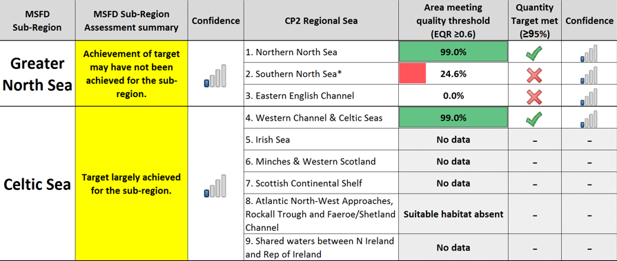
Figure 1. Proportion of total saltmarsh extent achieving less than the indicator quality threshold with corresponding environmental status for intertidal habitats of each UK Regional Sea. * includes Water Framework Directive Good Ecological Potential.

Figure 2. UK Regional Seas with corresponding assessment results with locations of coastal water bodies used for Water Framework Directive saltmarsh classifications with corresponding ecological status.
The overall indicator target may not have been achieved for the Greater North Sea Marine Strategy Framework Directive sub-region, with a considerable proportion of its assessed area failing to meet the indicator quality target. While the indicator quality threshold has been met for all contributing water bodies in the Northern North Sea, the results indicate that sufficient areas of the Southern North Sea and Eastern English Channel UK Regional Seas are below the quality extent threshold to result in the likely failure of the Marine Strategy Framework Directive sub-region. In the Southern North Sea and Eastern English Channel UK Regional Seas, most water bodies assessed as below the quality target are within water bodies categorised as a Heavily Modified Water Body for morphological alteration pressures. Of these, only a single water body in the Southern North Sea (Blackwater Outer) has sufficient mitigation measures in place to meet the target of Good Ecological Potential.
The overall target has largely been achieved within the Celtic Seas Marine Strategy Framework Directive sub-region, with the majority of its assessed area within its constituent UK Regional Sea (Western Channel and Celtic Seas) meeting the quality target.
Five UK Regional Seas have not been assessed due to either an absence of intertidal habitat or an absence of Water Framework Directive classification data.
The confidence for Water Framework Directive saltmarsh indicator assessments has been categorised as low for all UK Regional Seas, primarily due to the low spatial coverage of the Water Framework Directive assessments, and the low coverage of water bodies categorised as being ‘At Risk’ or ‘Probably at Risk’ from morphological alteration and/or diffuse source pollution pressures from the Water Framework Directive risk assessments.
Trend assessment
Unknown: The aggregated Water Framework Directive results were not considered as part of the 2012 Initial Assessment.
Further information
This first assessment is based on aggregated results from the classifications derived for the 2015 UK River Basin Management Plans and additional offshore data for the 2009 to 2015 period. The method is based on the intertidal saltmarsh assemblages and considered responsive to hydromorphological and nutrient enrichment pressures from inshore activities.
The indicator determines the impact to the ecological quality of saltmarsh communities of intertidal habitats by combining measures of saltmarsh extent which includes current extent, proportion of historical extent, and extent change, along with proportions of zones present, extent of the dominant zone as a proportion of the total extent, and the number of observed saltmarsh taxa as a proportion of a historic reference. The metrics are combined within an Ecological Quality Ratio, with weightings set within the tool to most suitably correspond to changes within saltmarsh communities resulting from anthropogenic pressures. Metrics are calculated at the level of the Water Framework Directive water body using data collected within a 6-year period. The water body assessments indicate the extent to which the entire saltmarsh community deviates from reference conditions and relates this to the boundary between Moderate and Good Ecological Status (Ecological Quality Ratio ≥0.60) to identify whether the water body has achieved the target of Good Ecological Status. The quantity target is met where ≥95% (priority habitat threshold) of the assessed surface area meets the quality target of Good or High Ecological Status or Good Ecological Potential.
The UK Water Framework Directive risk assessments identified that a total of 24% (95 of the 396 assessed) of coastal water bodies are ‘At Risk’ or ‘Probably at Risk’ of failing to meet their environmental objectives as a result of pressures categorised as morphological alterations and diffuse source pollution (including nutrient enrichment) pressures.
Detailed assessment results for each Marine Strategy Framework Directive sub-region are presented for each of their component UK regional sea. The sub-regions comprise of the regional seas as follows:
Greater North Sea Marine Strategy Framework Directive sub-region
- Northern North Sea
- Southern North Sea
- Eastern English Channel
Celtic Seas Marine Strategy Framework Directive sub-region
- Western Channel and Celtic Seas
- Irish Sea
- Minches and Western Scotland
- Scottish Continental Shelf
- Atlantic North-West Approaches, Rockall Trough, and Faeroe/Shetland Channel
- Shared Waters between Northern Ireland and Republic of Ireland
Northern North Sea
The overall risk of the Northern North Sea failing to meet the target for saltmarsh can be considered as low. Both Water Framework Directive assessments within the Northern North Sea indicate that saltmarsh communities are above the indicator quality target, both being at Water Framework Directive Good Ecological Status (Figure 3).
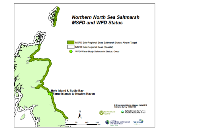
Figure 3. Outline of the Northern North Sea inshore indicating intertidal saltmarsh Marine Strategy Framework Directive assessment result and location and ecological status of the corresponding Water Framework Directive water bodies.
The corresponding risk assessments for the water bodies indicate one water body categorised as ‘At Risk’ or ‘Probably at Risk’ of failing to achieve the indicator quality target as a result of morphological alterations and/or diffuse source pollution pressures, with the remaining classified water body being ‘Not at Risk’ or ‘’Probably Not at Risk’ of failing (Table 2). However, the UK Regional Sea intersects with a total of 71 water bodies, whereby a further 9 water bodies exist within the Northern North Sea. These are considered ‘At Risk’ from morphological alterations and/or diffuse source pollution pressures and have not been assessed with the saltmarsh indicator.
When considering indicator quality targets for Heavily Modified Water Bodies (Water Framework Directive Good Ecological Potential), none of the water bodies assessed as below the indicator quality target are categorised as Heavily Modified Water Bodies, so meeting a target of Good Ecological Potential is not considered.
The overall confidence in the Northern North Sea UK Regional Sea saltmarsh assessment is categorised as low. This is primarily based on the low spatial coverage of the assessment data (2 out of 71 water bodies within the UK Regional Sea). The confidence in the assessment is also reduced due to a low correspondence between the saltmarsh indicator, and morphological alterations and/or diffuse source pollution pressures (Kappa agreement of 0.372).
Table 2. Summary of Water Framework Directive water body pressure information and Water Framework Directive saltmarsh index classification results aggregated to the Northern North Sea Regional Sea Marine Strategy Framework Directive assessments.
|
Water body |
Agency |
Heavily Modified Water body |
Diffuse Source Pollution pressure |
Morphological alteration pressures |
Saltmarsh Current Extent (Ha) |
Water body Ecological Quality Ratio |
Water Framework Directive status |
|
Farne Islands to Newton Haven |
Environment Agency |
No |
Not at Risk/Probably Not at Risk |
Not at Risk/Probably Not at Risk |
30.1 |
0.66 |
Good |
|
Holy Island & Budle Bay |
Environment Agency |
No |
At Risk/Probably at Risk |
Not at Risk/Probably Not at Risk |
246.9 |
0.72 |
Good |
Southern North Sea
The overall risk of the Southern North Sea failing to meet the target for saltmarsh can be considered as high. The majority of Water Framework Directive assessments within the Southern North Sea indicate that saltmarsh communities are above the indicator quality target, being predominantly at Water Framework Directive Moderate Ecological Status (3 of the 4 water bodies) with the remainder at Good Ecological Status (Figure 4).
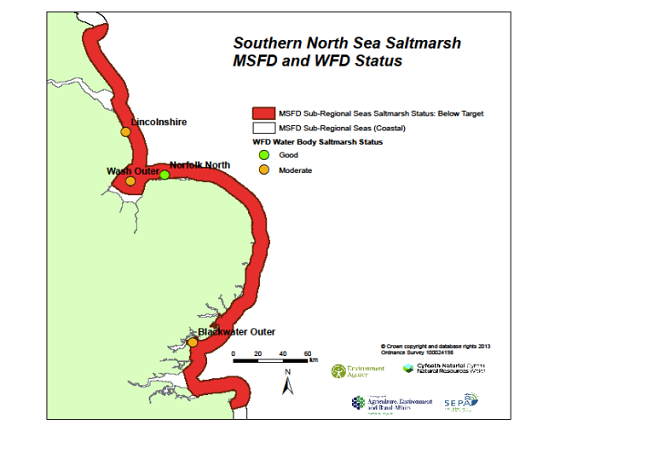
Figure 4. Outline of the Southern North Sea inshore indicating intertidal saltmarsh Marine Strategy Framework Directive assessment result and location and ecological status of the corresponding Water Framework Directive water bodies.
The corresponding risk assessments for the water bodies indicate 4 water bodies categorised as ‘At Risk’ or ‘Probably at Risk’ of failing to achieve the indicator quality target as a result of morphological alterations and/or diffuse source pollution pressures, with no classified water bodies being ‘Not at Risk’ or ‘’Probably Not at Risk’ of failing (Table 3). However, the UK Regional Sea intersects with a total of 13 water bodies, whereby a further 13 water bodies exist within the Southern North Sea. These are considered ‘At Risk’ from morphological alterations and/or diffuse source pollution pressures and have not been assessed with the saltmarsh indicator.
The Blackwater Outer and Lincolnshire water bodies are categorised as Heavily Modified Water Bodies. The Marine Strategy Framework Directive indicator quality target, therefore, corresponds to Good Ecological Potential under Water Framework Directive for these water bodies, which is met if sufficient mitigation measures are in place. The corresponding Mitigation Measures Assessments classifies the Blackwater Outer water body as ‘Good’, so the indicator quality target has been achieved in this case. However, the Mitigation Measures Assessment for the Lincolnshire water body has resulted in a classification of ‘Moderate or less’ so the indicator quality target has not been achieved in this case.
The overall confidence in the Southern North Sea UK Regional Sea saltmarsh assessment is categorised as low. This is primarily based on the low spatial coverage of the assessment data (4 out of 13 water bodies within the UK Regional Sea). The confidence in the assessment is also reduced due to a low correspondence between the saltmarsh indicator and morphological alterations and/or diffuse source pollution pressures (Kappa agreement of 0.372), and the moderate variability in Water Framework Directive water body status within the Southern North Sea UK Regional Sea.
Table 3. Summary of Water Framework Directive water body pressure information and Water Framework Directive saltmarsh index classification results aggregated to the Southern North Sea Regional Sea Marine Strategy Framework Directive assessments. * = mitigation measures in place to achieve Good Ecological Potential.
|
Water body |
Agency |
Heavily Modified Water body |
Diffuse Source Pollution pressure |
Morphological alteration pressures |
Saltmarsh Current Extent (Ha) |
Water body Ecological Quality Ratio |
Water Framework Directive status |
|
Blackwater Outer |
Environment Agency |
Yes |
At Risk/Probably at Risk |
At Risk/Probably at Risk |
267.9 |
0.42 |
Good * |
|
Lincolnshire |
Environment Agency |
Yes |
Not at Risk/Probably Not at Risk |
At Risk/Probably at Risk |
561.0 |
0.56 |
Moderate |
|
Norfolk North |
Environment Agency |
Yes |
At Risk/Probably at Risk |
At Risk/Probably at Risk |
326.0 |
0.61 |
Good |
|
Wash Outer |
Environment Agency |
No |
Not At Risk/Probably Not At Risk |
At Risk/Probably at Risk |
1259.1 |
0.50 |
Moderate |
Eastern English Channel
The overall risk of the Eastern English Channel failing to meet the target for saltmarsh can be considered as high. The existing Water Framework Directive assessment within the Eastern English Channel indicates that saltmarsh communities are above the indicator quality target, being at Water Framework Directive Moderate Ecological Status (Figure 5).
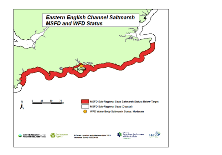
Figure 5. Outline of the Eastern English Channel inshore indicating intertidal saltmarsh Marine Strategy Framework Directive assessment result and location and ecological status of the corresponding Water Framework Directive water bodies.
The corresponding risk assessments for the water bodies indicate one water body categorised as ‘At Risk’ or ‘Probably at Risk’ of failing to achieve the indicator quality target as a result of morphological alterations and/or diffuse source pollution pressures, with no classified water bodies being categorised as ‘Not At Risk’ or ‘Probably Not at Risk’ of failing (Table 4). However, the UK Regional Sea intersects with a total of 18 water bodies, whereby a further 15 water bodies exist within the Eastern English Channel. These are considered ‘At Risk’ from morphological alterations and/or diffuse source pollution pressures and have not been assessed with the saltmarsh indicator.
The Solent water body is categorised as a Heavily Modified Water Body. The Marine Strategy Framework Directive indicator quality target, therefore, corresponds to Good Ecological Potential under Water Framework Directive for this water body, which is met if sufficient mitigation measures are in place. However, the corresponding Mitigation Measures Assessment classifies the water body as ‘Moderate or less’ so Good Ecological Potential has not been achieved.
The overall confidence in the Eastern English Channel UK Regional Sea saltmarsh assessment is categorised as low. This is primarily based on the low spatial coverage of the assessment data (one out of 18 water bodies within the UK Regional Sea). The confidence in the assessment is also reduced due to a low correspondence between the saltmarsh indicator and morphological alterations and/or diffuse source pollution pressures (Kappa agreement of 0.372).
Table 4. Summary of Water Framework Directive water body pressure information and Water Framework Directive saltmarsh index classification results aggregated to the Eastern English Channel Regional Sea Marine Strategy Framework Directive assessments.
|
Water body |
Agency |
Heavily Modified Water body |
Diffuse Source Pollution pressure |
Morphological alteration pressures |
Saltmarsh Current Extent (Ha) |
Water body Ecological Quality Ratio |
Water Framework Directive status |
|
Solent |
Environment Agency |
Yes |
At Risk/Probably at Risk |
At Risk/Probably at Risk |
132.9 |
0.56 |
Moderate |
Western Channel and Celtic Seas
The overall risk of the Western Channel and Celtic Seas Regional Sea failing to meet the target for saltmarsh can be considered as low. All Water Framework Directive assessments within the Western Channel and Celtic Seas indicate that saltmarsh communities are above the indicator quality target, being at Water Framework Directive Good Ecological Status in both cases (Figure 6).
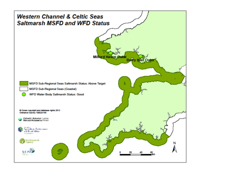
Figure 6. Outline of the Western Channel and Celtic Seas inshore indicating intertidal saltmarsh Marine Strategy Framework Directive assessment result and location and ecological status of the corresponding Water Framework Directive water bodies.
The corresponding risk assessments for the water bodies indicate one water body categorised as ‘At Risk’ or ‘Probably at Risk’ of failing to achieve the indicator quality target as a result of morphological alterations and/or diffuse source pollution pressures, with the remaining classified water body being ‘Not at Risk’ or ‘’Probably Not at Risk’ of failing (Table 5). However, the UK Regional Sea intersects with a total of 28 water bodies, whereby a further 16 water bodies exist within the Western Channel and Celtic Seas. These are considered ‘At Risk’ from morphological alterations and/or diffuse source pollution pressures and have not been assessed with the saltmarsh indicator.
When considering indicator quality targets for Heavily Modified Water Bodies (Water Framework Directive Good Ecological Potential), none of the water bodies assessed as below the indicator quality target are categorised as Heavy Modified Water Bodies, so meeting a target of Good Ecological Potential is not considered.
The overall confidence in the Western Channel and Celtic Seas UK Regional Sea saltmarsh assessment is categorised as low. This is primarily based on the low spatial coverage of the assessment data (2 out of 28 water bodies within the UK Regional Sea). The confidence in the assessment is also reduced due to a low correspondence between the saltmarsh indicator and morphological alterations and/or diffuse source pollution pressures (Kappa agreement of 0.372).
Table 5. Summary of Water Framework Directive water body pressure information and Water Framework Directive saltmarsh index classification results aggregated to the Western Channel & Celtic Seas Regional Sea Marine Strategy Framework Directive assessments.
|
Water body |
Agency |
Heavily Modified Water body |
Diffuse Source Pollution pressure |
Morphological alteration pressures |
Saltmarsh Current Extent (Ha) |
Water body Ecological Quality Ratio |
Water Framework Directive status |
|
Burry Inlet Outer |
Natural Resources Wales |
No |
Not at Risk/Probably Not at Risk |
Not at Risk/Probably Not at Risk |
1048.5 |
0.78 |
Good |
|
Milford Haven Outer |
Natural Resources Wales |
No |
At Risk/Probably at Risk |
At Risk/Probably at Risk |
38.9 |
0.79 |
Good |
Conclusions
The target for the saltmarsh communities has been largely met for the Celtic Seas Marine Strategy Framework Directive sub-region but has not been met for considerable areas of the Greater North Sea Marine Strategy Framework Directive sub-region, although confidence in the assessment is low.
The indicator target has been met for 2 of the 4 assessed UK Regional Seas. In the remaining 2, considerable areas of assessed saltmarsh have not achieved the quality threshold. The pressures which impact the saltmarsh communities operate over small spatial scales with their effect being relatively localised. Assessment of the indicator at the Regional Sea scale may, therefore, be considered of greater relevance.
Reduction in the quality of saltmarsh communities may be occurring within the Southern North Sea and Eastern English Channel, potentially accountable to hydromorphological pressures within Heavily Modified Water Bodies. Sufficient mitigation measures are in place for only one Heavily Modified Water Body within the Southern North Sea with further mitigation measures required if Water Framework Directive Good Ecological Potential is to contribute to meeting Marine Strategy Framework Directive targets in these UK Regional Seas. The results reflect the overall achievement of targets within the assessment period and are unable to provide directional trends.
The results are based on a low number of surveys with additional data required to confirm the failures with detailed investigation of the saltmarsh communities and corresponding pressures being required before any reasons for failures can be confirmed.
The results may inform data collection and research requirements to improve the confidence and accuracy of future assessments.
Knowledge gaps
The knowledge gaps accompanying the assessments include the following:
- The assessments represent a small proportion of the overall UK coastline with Water Framework Directive assessments provided for 9 out of 475 coastal water bodies. The natural conditions required for saltmarsh beds to exist limits their occurrence in coastal water bodies.
- Saltmarsh classifications were not undertaken for for Scotland and Northern Ireland between 2009 and 2015.
- A comprehensive dataset of the full available intertidal habitat for saltmarsh is not yet available.
- The index does not account for accreting or drowning shores.
- The saltmarsh index is not calibrated for different grazing pressures.
- Rare species are weighted equally to common species within the index and may provide an underestimate of biodiversity
References
HM Government (2012) ‘Marine Strategy Part One: UK Initial Assessment and Good Environmental Status’ (viewed on 5 July 2018)
HM Government (2015) ‘Marine Strategy Part Three: UK Programme of Measures’ December 2015 (viewed on 5 July 2018)
European Commission (1991a) 'Council Directive 91/271/EEC of 21 May 1991 concerning urban waste-water treatment' Official Journal of the European Union L 135, 30.5.1991, pages 40–52 (viewed on 8 October 2018).
European Commission (1991b) 'Council Directive 91/676/EEC of 12 December 1991 concerning the protection of waters against pollution caused by nitrates from agricultural sources' Official Journal of the European Union L 375, 31.12.1991, pages 1–8 (viewed on 8 October 2018).
European Council (1992) ‘Council Directive 92/43/EEC of 21 May 1992 on the conservation of natural habitats and of wild fauna and flora’ Official Journal of the European Union L 206, 22.7.1992, pages 7-50 (viewed 1 October 2018)
European Commission (2000) ‘Directive 2000/60/EC of the European Parliament and of the Council of 23 October 2000 establishing a framework for Community action in the field of water policy’ Official Journal of the European Union L 327, 22.12.2000, pages 1–73 (viewed on 8 October 2018)
OSPAR Commission (2012) ‘Meeting of the Intersessional Correspondence Group on Biodiversity Assessment and Monitoring: ICG COMBAM(3)’ 5-6 December 2012, Brussels. Chaired by Narberhaus I and Zweifel UL (viewed on 15 January 2019)
OSPAR Commission (2017) ‘Intermediate Assessment 2017’ (viewed on 21 September 2018)
UKMMAS (2010) 'Charting Progress 2: An assessment of the state of the UK seas' Published by Defra on behalf of the UK Marine Monitoring and Assessment Strategy community (viewed on 15 January 2019)
WFD-UKTAG (Water Framework Directive UK Technical Advisory Group) (2007) ‘UK Environmental Standards and Conditions (Phase 2)’ Final: SR1-2007, March 2008 (viewed on 15 January 2019)
Acknowledgements
Assessment metadata
| Assessment Type | UK Marine Strategy Framework Directive Indicator Assessment |
|---|---|
D1 - Biological Diversity D6 – Seafloor Integrity | |
Condition of intertidal saltmarsh communities in coastal waters determined using Water Framework Directive methods | |
In addition to links provided in ‘References’ section above: European Commission (2008) ‘Directive 2008/56/EC of the European Parliament and of the Council of 17 June 2008 establishing a framework for community action in the field of marine environmental policy (Marine Strategy Framework Directive)’ Official Journal of the European Union L 164, 25.6.2008, pages 19-40 (viewed on 16 November 2018) | |
| Point of contact email | marinestrategy@defra.gov.uk |
| Metadata date | Friday, June 1, 2018 |
| Title | Condition of intertidal saltmarsh communities in coastal waters determined using Water Framework Directive methods |
| Resource abstract | Marine Strategy Framework Directive Regional Seas were assessed using aggregated Water Framework Directive classification results for the saltmarsh indicator as undertaken for the Cycle 2 River Basin Management Plans for England and Wales. Marine Strategy Framework Directive environmental objective targets were set according to WFD quality targets and UK Technical Advisory Group spatial criteria and favourable condition assessment thresholds. The targets covering the area of intertidal saltmarsh communities at an acceptable condition has largely been achieved in the Celtic Sea Marine Strategy Framework Directive Sub-Region but has not been met for the Greater North Sea. |
| Linkage | In addition to references provided in above:HM Government (2015) ‘The Water Framework Directive (Standards and Classification) Directions (England and Wales) 2015’ (viewed on 13 January 2019) HM Government (2015) ‘The Water Framework Directive (Classification, Priority Substances and Shellfish Waters) Regulations (Northern Ireland) 2015’ (viewed on 13 January 2019) Scottish Government (2014) ‘The Scotland River Basin District (Standards) Directions 2014’ (viewed on 13 January 2019) WFD-UKTAG (Water Framework Directive UK Technical Advisory Group) (2014) ‘UKTAG Transitional and Coastal Water Assessment Method, Angiosperms: Saltmarsh Tool’ April 2014, ISBN: 978-1-906934-36-1 (viewed on 13 January 2019) Water Framework Directive Cycle 2 River Basin Management Plans: |
| Conditions applying to access and use | © Crown copyright, licenced under the Open Government Licence (OGL). |
| Assessment Lineage | Background:This indicator is used to assess progress against the Water Framework Directive ecological status boundaries and areas of unacceptable impact, which are components of the Marine Strategy Framework Directive sediment habitats targets, set in the UK Marine Strategy Part One. Sources of data:Assessments use data from WFD monitoring used within the Cycle 2 River Basin Management Plans for England and Wales. Data processing:The saltmarsh index calculated for the Cycle 2 RBMPs used for the Marine Strategy Framework Directive UK assessment can be calculated using the Saltmarsh Key Indicators Processed Precisely and Estimated Robustly (SKIPPER) Microsoft Excel workbook (available for download from UKTAG). The approach to aggregating the WFD water body classifications to the Marine Strategy Framework Directive Sub-Regions and UK Charting Progress 2 (CP2) Regional Seas is as follows:
The final CP2 Regional Sea assessment is calculated using the total percentage of saltmarsh extent within all classified water bodies which meets the indicator quality target. The overall indicator target is achieved when the extent of classified saltmarsh meeting the quality target is 95% of all classified saltmarsh beds within a CP2 Regional Sea. |
| Indicator assessment results | |
| Dataset metadata | |
| Links to datasets identifiers | Please, see below |
| Dataset DOI |
The Metadata are “data about the content, quality, condition, and other characteristics of data” (FGDC Content Standard for Digital Geospatial Metadata Workbook, Ver 2.0, May 1, 2000).
Metadata definitions
Assessment Lineage - description of data sets and method used to obtain the results of the assessment
Dataset – The datasets included in the assessment should be accessible, and reflect the exact copies or versions of the data used in the assessment. This means that if extracts from existing data were modified, filtered, or otherwise altered, then the modified data should be separately accessible, and described by metadata (acknowledging the originators of the raw data).
Dataset metadata – information on the data sources and characteristics of data sets used in the assessment (MEDIN and INSPIRE compliance).
Digital Object Identifier (DOI) – a persistent identifier to provide a link to a dataset (or other resource) on digital networks. Please note that persistent identifiers can be created/minted, even if a dataset is not directly available online.
Indicator assessment metadata – data and information about the content, quality, condition, and other characteristics of an indicator assessment.
MEDIN discovery metadata - a list of standardized information that accompanies a marine dataset and allows other people to find out what the dataset contains, where it was collected and how they can get hold of it.
Recommended reference for this indicator assessment
Phillips, G.1, McGruer, K.1, Crook, D.2, Doria, L.3, Herbon, C.3, Khan, J.4, Mackie, T.5, Singleton, G.3 & Young, C.5 2018. Condition of intertidal saltmarsh communities in coastal waters determined using Water Framework Directive methods. Marine Online Assessment Tool, available at: https://moat.cefas.co.uk/biodiversity-food-webs-and-marine-protected-areas/benthic-habitats/intertidal-saltmarsh/
1Environment Agency
2Natural Resources Wales
3Joint Nature Conservation Committee
4Scottish Environment Protection Agency
5Department of Environment, Agriculture & Rural Affairs, Northern Ireland
