
Changes in the abundance and distribution of seals
The UK target was met for grey seal abundance across its range in the UK, where the species has been increasing. The UK target for harbour seal abundance has not been met in the Greater North Sea and in the Celtic Seas, and the assessment was uncertain. Harbour seal abundance is stable or increasing along the English North Sea coast but has declined along the Scottish North Sea coast. The causes of these declines are currently unknown, although a number of potential factors have been discounted as causal factors of the decline. For the Celtic Seas, there was a significant increase in abundance in west Scotland where the majority of harbour seals are, but there was inconclusive evidence of declines elsewhere.
Background
UK target on changes in the abundance and distribution of seals
This indicator is used to assess progress against the following targets, which are set in the UK Marine Strategy Part One (HM Government, 2012) for each of the two species of seal native to UK waters (Atlantic grey seal (Figure 1) and the harbour seal (Figure 2)):
Population size: At the scale of the Marine Strategy Framework Directive sub-regions, abundance of seals is not decreasing as a result of human activity. In all of the indicators monitored, there should be no statistically significant decrease in abundance of marine mammals caused by human activities.
Distribution: At the scale of the Marine Strategy Framework Directive sub-regions, the distribution of seals is not contracting as a result of human activities: in all of the indicators monitored there is no statistically significant contraction in the distribution of marine mammals caused by human activities.
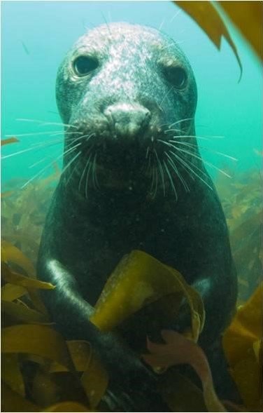
Figure 1. Atlantic grey seal (courtesy of John Weinberg).
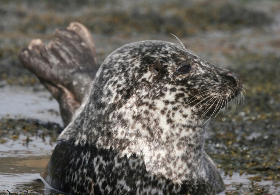
Figure 2. Harbour seal (courtesy of Sea Mammal Research Unit)
Key pressures and impacts
Disease, competition with other species, changes in distribution and abundance of their prey, and disturbance and interactions with fisheries can all affect seal abundance and distribution. Seals were hunted into the 20th century but are now protected from such activity throughout the UK.
Measures taken to address the impacts
Measures to protect seals are set out in the UK Marine Strategy Part Three (HM Government, 2015). These include protection through many national, European, and international conventions, agreements, and regulations that aim to manage the impacts of human activities on the seal population.
Monitoring, assessment, and regional co-operation
Areas that have been assessed
The European population of harbour seals has been subdivided into a number of assessment units while the grey seal population was assessed as a single spatial unit (Figure 3). OSPAR was advised on the use of these units by The International Council for the Exploration of the Sea. The single grey seal assessment unit covers the whole of the Greater North Sea (using data from other North Sea countries) and the UK parts of the Celtic Seas (data from the Republic of Ireland were not available). However, grey seal distribution was assessed using the smaller assessment units already defined for harbour seals to provide smaller scale resolution.
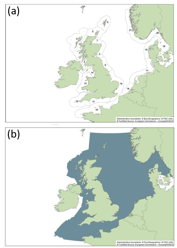
Figure 3: Marine Strategy Framework Directive assessment units for (a) harbour seals and (b) grey seal distribution. 1. Northern Ireland, 2. South West Scotland, 3. West Scotland, 4. The Western Isles, 5. NorthCoast and Orkney, 6. Shetland, 7. Moray Firth, 8. East Scotland, 9. North East England, 10. South East England, 11. South England, 12. South West England, 13. Wales, 14. North West England, 15. French North Sea and Channel Coast, 16. Belgium Coast and Dutch Delta, 17. The Wadden Sea, 18. Limfjorden, 19. Kattegat, 20. Northern Skagerrak and Oslo Fjord, 21. Norwegian West Coast, south of 62N. (Source: Eurostat).
Monitoring and Assessment methods
This indicator uses estimates of seal numbers from monitoring programmes that count seals on land when they are moulting (harbour seal) or breeding (grey seal). Trends in the abundance of harbour seals counted during the annual moult in August were assessed within each assessment unit. Because the single large spatial unit for grey seals covers colonies beyond UK waters, the total abundance of grey seals was modelled using both summer counts of grey seals and counts of pups at grey seal colonies during the autumn and winter. Trends in both species were assessed over the short-term (2009 to 2014) and the long-term (1992 to 2014, for most areas).
Assessment thresholds
The target for population size in each assessment unit was met when a) seal abundance during 2009 to 2014 declined by less than an average of 1% per year, or b) seal abundance decreased by less than 25% since the baseline year (1992 or start of time series, if later). These thresholds are based on those used by OSPAR in its Intermediate Assessment (OSPAR Commission, 2017).
Changes in distribution were only used as a ‘surveillance indicator’ to help interpret changes in abundance. Therefore, the distribution metrics were not compared with any thresholds.
Regional cooperation
This UK has led this indicator assessment as part of the OSPAR Intermediate Assessment 2017 (OSPAR Commission, 2017).
stuff
Further information
Two species of seal live in UK waters: Atlantic grey seals (Halichoerus grypus) and harbour seals (Phoca vitulina). Atlantic grey seals (referred to hereafter as ‘grey seals’) only occur in the North Atlantic, Barents and Baltic Seas with their main concentrations on the east-coast of Canada and United States of America and in north-west Europe. Within north-west Europe, the greatest concentration of grey seals is around UK coasts, especially in Scottish coastal waters. Approximately 38% of the world’s grey seals breed in the UK and 88% of these at colonies in Scotland, with the main concentrations in the Outer Hebrides and Orkney. Harbour seals have a circumpolar distribution in the Northern Hemisphere and are divided into five sub-species. The population in European waters represents one subspecies (Phoca vitulina vitulina). Approximately 30% of European harbour seals are in the UK, this proportion has declined from about 40% in 2002. Harbour seals are widespread around the west-coast of Scotland and throughout the Hebrides and Northern Isles. On the east coast, their distribution is more restricted with concentrations in the major estuaries of the Thames, the Wash, the Firth of Tay, and the Moray Firth. Scotland holds about 79% of the UK harbour seal population, with 16% in England and 5% in Northern Ireland.
As top predators, seals can be used as an indicator to reflect the state of the marine ecosystem. This assessment of seal abundance and distribution aims to determine if populations of both species are in a healthy state, with no long-term decrease in population size beyond natural variability. Assessments of changes in abundance and distribution were made within discrete geographical areas of coastline, or ‘assessment units’. The seals counted within each assessment unit are more likely to forage in a similar area of the sea and to be more closely related to one another. Grey seals forage across a much wider area, so their abundance is assessed across the whole of the Greater North Sea and the UK parts of the Celtic Seas using a single assessment unit (Figure 3b). It is important to note that grey seal populations exist along the coast of Ireland but data from Ireland were not available to be included in the European-level assessment. A single large assessment unit was not considered appropriate for assessing the distribution pattern of grey seals because of the substantial loss of local-scale information. Grey seal distribution was therefore assessed using the smaller assessment units defined for harbour seals (Figure 3a). The large number of small assessment units for harbour seals reflects the fact that they tend to range over shorter distances and this aids management of the species for licensing purposes.
Assessment method
Indicator metric and data collection
This indicator assessment uses estimates of seal numbers from monitoring programmes that count seals on land when they are moulting (harbour seal) or breeding (grey seal). Trends in the abundance of harbour seals counted during the annual moult (every August) were assessed within each assessment unit. Because the single large assessment unit for grey seals covers colonies beyond UK waters, the total abundance of grey seals was modelled using both summer counts of grey seals and counts of pups at grey seal colonies during the autumn and winter. Trends in both species were assessed over the short-term (2009 to 2014) and the long-term (1992 to 2014, for most areas).
The presence or absence of seals at monitored haul-out and breeding sites was used to assess changes in the number of sites occupied (occupancy rate) and the number of sites deserted or newly colonised (distributional shift). Changes in occupancy rate and distributional shift were compared between the periods 2003 to2008 and 2009 to 2014 for both species in each of the assessment units used for the harbour seal abundance assessment (Figure 3a). Seal abundance surveys are not designed to detect changes in distribution. They reflect the distribution of seals only at specific times of the year. Therefore, change in distribution is used as a ‘surveillance indicator’ to help interpret changes in abundance. The distribution metrics were not compared with any thresholds.
Seal Monitoring in the North East Atlantic
Grey seals and harbour seals are surveyed when they come ashore (‘haul-out’) and can be most easily counted. Surveys are usually conducted from the air but may also be conducted from land or by boat. In most areas, aerial surveyors take photographs of the haul-out sites and animals are later counted from the images (Figure 4). Grey seal population trends are assessed from the counts of pups born during the autumn breeding season when females congregate on land to give birth. Harbour seals are counted while they are on land during their August moult, giving a minimum estimate of population size. Not all areas are counted every year but the aim is to cover the entire UK coast every five-years. Using telemetry data, the proportion of seals hauled out during the survey window is estimated.
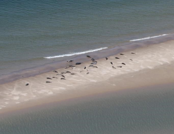
Figure 4. Aerial survey image of harbour seals hauled-out (courtesy of Chris Morris, Sea Mammal Research Unit).
During the harbour seal surveys, grey seals are also counted. The number of grey seals hauled out during the harbour seal moult can be very variable. The total number of grey seal pups born at colonies during the autumn/winter breeding season is also counted. Assessment of trends in abundance of both species was only completed where at least four individual annual data points were available.
Spatial scope
The European populations of both grey and harbour seals were subdivided into a number of assessment units (Figure 3). These spatial units were based on proposals by ICES (2014a) and cover their full distributional range. It is important to note that assessment units do not represent demographically independent populations. Additionally, survey coverage and monitoring effort is high for both species where they are most abundant. In some assessment units, monitoring is undertaken in specific areas by local organisations and does not form part of synoptic national surveys programmes.
Harbour seal assessment units
The harbour seal assessment units are shown in Figure 3a. The assessment units in the Greater North Sea are broadly similar to those previously defined as OSPAR Ecological Quality Objective sub-units (OSPAR Commission, 2010). The assessment units for this species are much smaller than those used for grey seals because harbour seals tend to undertake shorter excursions from their favoured haul-out sites, and there is some evidence of population structuring in European harbour seals (for example: Goodman, 1998; Olsen and others, 2014).
Grey seal assessment units
Grey seals range more widely at sea than harbour seals and may visit multiple distant haul-out sites. (McConnell and others, 1999). Immigration of grey seals may account for as much as 35% of the observed population growth in the Dutch Wadden Sea (Brasseur and others, 2015) and hundreds of adults from the UK visit the area temporarily. Grey seal abundance was therefore assessed across the whole of the OSPAR regions II and III as a single assessment unit (Figure 3b).
A single large assessment unit was not considered appropriate for assessing the distribution pattern of grey seals because of the substantial loss of local-scale information. Grey seal distribution was therefore assessed using the smaller assessment units already defined for harbour seals (Figure 3a). Despite their ability to travel long distances, individual mature grey seals of both sexes are usually faithful to particular breeding sites and may return to within 10 to 100m of individual breeding locations (Pomeroy and others, 2000). Insights into the seasonal movement of grey seals in the UK from telemetry data indicate that grey seal breeding distribution can be considerably different from their foraging distribution during other times of the year (Russell and others, 2013). Grey seal distribution metrics are presented both for the breeding colony locations and non-breeding seasons (grey seal moult) where this information is available.
Grey seal abundance estimation
The data provided and used in this assessment consist of grey seal counts conducted during surveys of harbour seals during their summer moult in August and counts of grey seal pups made at breeding colonies in the autumn and winter.
The summer counts of grey seals can be quite variable and are not, on their own, a reliable estimate of the size of the grey seal breeding population because:
- a large proportion of grey seals will not be hauled out on land and counted during the harbour seal moult, and this proportion can vary considerably,
-
animals counted in a particular location during the summer are not necessarily those that breed in the same area, because grey seals may travel extensively between breeding and foraging sites (Brasseur and others, 2015; Russell and others, 2013),
- as in summer more grey seals lie in the midst of harbour seals, there may be confusion between the species in this season and over or underestimation is more likely than in other seasons.
The first of these concerns can be addressed by estimating the proportion of time grey seals spent hauled out during August surveys using telemetry (geolocation) data. The fact that grey seals form large breeding colonies in the autumn and winter provides an indirect way to estimate abundance by counting the number of pups born or ‘produced’ at a colony. Multiple surveys are conducted, and the number of pups is used in a statistical model to provide an estimate of the total number of pups produced at that colony during the entire breeding season known as ‘pup production’.
Pup production estimates and prior knowledge of life history parameters which include, pup survival, adult survival, and fecundity were incorporated into a Bayesian state-space model currently used by the Seal Mammal Research Unit in the UK to estimate total population size and life history parameters (Special Committee on Seals, 2014). This model had to be fitted at a sub-regional level because previous work in the UK has shown that pup survival is density dependent and acts on a more local scale. Movement of females was also estimated, recognizing that some females born in the UK recruit into the breeding population in continental Europe (Brasseur and others, 2015). Like pup survival, movement was assumed to be density dependent.
The population model provides estimates of total grey seal abundance for the Greater North Sea and the UK parts of the Celtic Seas. These model outputs were then compared to the total number of grey seals estimated from summer counts in a single year. The total grey seal summer population of the Greater North Sea and the UK parts of the Celtic Seas was estimated using summer haul out counts in 2008. This was the year with the most comprehensive survey coverage in Scotland, where most of the population is found. If no counts were made in 2008 for an area, but there were counts made both before and after 2008, the count in 2008 was estimated (interpolated) from these counts. If there were only counts either before or after 2008, the count from the nearest year was used. Using telemetry data on the proportion of time grey seals in the UK haul out during the usual survey window (0.31; Lonergan and others, 2011), the total population size in summer 2008 was estimated. The annual estimates produced by the pup production model were refined by inputting the estimated summer population in 2008.
For further details of the analytical method, and its development, please see Special Committee on Seals (2014).
Baselines
Seals have been hunted both illegally and legally for a long time and it is therefore not possible to know their undisturbed state, nor the current carrying capacity that could be attained alongside protection from illegal hunting. Time-series data for abundance and distribution of both seal species do not indicate when an un-impacted state might have occurred and what it would look like in terms of abundance and distribution. It is therefore not possible to identify a baseline representing un-impacted conditions.
The baseline used was the abundance estimate for each species in 1992 (where these data are available), the baseline year used by some European Countries for seals under the Habitats Directive. For harbour seal, data for 1992 were not available in all assessment units; in such cases, the start of the data time series was used as the baseline. For UK colonies, the baseline is 1994 but data is available for some colonies along the coast of continental Europe from 1992. Indicator thresholds were set as a deviation from the baseline value (Method 3; OSPAR Commission, 2012).
A short-term rate-based threshold was also adopted that uses a rolling baseline (Method 1; OSPAR Commission, 2012). Here, the average annual rate of population-change over consecutive six-year periods (equal to the Marine Strategy Framework Directive reporting cycle) was assessed against the next. The rolling baseline provides a means to indicate changes in population size compared with the previous six-year assessment period, rather than relying solely on a historical fixed baseline that probably reflects a time when the population had already been subject to anthropogenic pressures.
A potential problem with this type of quantitative trend assessment is the concept known as ‘shifting baselines: each successive assessment uses a different starting point as a basis for comparison. This could result in a substantial cumulative decrease occurring over more than one six-year assessment period not being flagged as a problem because, in a six-year period, the rate of decline remained below the threshold (OSPAR Commission, 2012).
Harbour seal and grey seal abundance thresholds
Two thresholds developed by OSPAR were used to assess grey and harbour seal abundance in each assessment unit. This usage aims to provide an indicator that would warn against a slow but steady long-term decline, (the problem of ‘shifting baselines’ associated with only having a rolling baseline) and against a recovery followed by a subsequent decline (potentially missed with a fixed baseline set below reference conditions). The two thresholds together would be able to act as a trigger for investigation of any necessary management measures to promote a steady recovery and subsequent slowing of growth as carrying capacity is approached.
The two thresholds used to assess grey and harbour seal abundance in each assessment unit in relation to the baselines above were:
- No decline in seal abundance of >1% per year in the previous six-year period (this is up to 6% over six-years). This uses a rolling baseline based on the previous six-year period which seeks to identify if seal populations are maintained in a healthy state, with no decrease in population size with regard to the baseline (beyond natural variability) and to identify if efforts are needed to restore populations, where they have deteriorated due to anthropogenic influences, to a healthy state. To estimate the annual increase or decrease in the number of animals counted within the previous six-years, a trend was fitted to the sum of all available data in each assessment unit for the period 2009 to 2014. Generalised linear models were fitted to count data with a quasi-Poisson error distribution and a log link. Annual growth rate (%) and 80% Confidence Intervals were estimated for each assessment unit. Although no formal hypothesis testing was conducted, 80% confidence intervals were calculated to reflect the choice to set the statistical significance level, α, equal to 0.20 or 20%.
- No decline in seal abundance of >25% since the fixed baseline in 1992 (or closest value). A fixed baseline (1992 data), as used by some European countries for seals under the Habitats Directive (or if such data are not available the start of the data series). The 25% chosen for the second threshold is currently approximately 1% a year since 1992. Testing shows that there is sufficient monitoring to assess against this threshold with confidence. Where a shorter timescale is assessed, the 25% decline since the baseline is not equivalent to those assessment units where data does extend to 1994. For example, a 25% decline since 2003 describes a more rapid contraction in the population than a 25% decline since 1994).
To determine the change in the abundance of seals since the baseline year, generalised linear models or generalised additive models were fitted to the sum of count data within an assessment unit with a quasi-Poisson error distribution and log link using all available annual survey data in the range 1994 to 2014. The percentage change in abundance since baseline year (Δ baseline) and 80% confidence intervals were calculated from fitted values. Although no formal hypothesis testing was conducted, 80% confidence intervals were calculated to reflect the choice to set the significance level, α, equal to 0.20 or 20% (Equation is given in Figure 5).
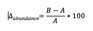
Figure 5: Calculation of the long-term trend in abundance., where A is the count fitted by the model in the baseline year and B is the count fitted by the model in the most recent survey year.
The statistical power of assessments
There are many ways in which the number of seals counted during any one year could vary, aside from representing true changes in population size. These include variation in weather or a disturbance at a haul-out site prior to counting. It is therefore advisable to examine the variability in survey counts and to incorporate this variability into trend or population size change estimates. ICES Working Group for Marine Mammal Ecology (ICES 2014b) provided general advice on the need to understand the statistical power of current and proposed monitoring programmes. In the present context, statistical power is the percentage confidence in not missing a significant decline. Statistical power depends on the sample size (number of surveys), the level of statistical significance set (α-level), variance in the counts, and the magnitude of the trend, in this case -1% and -2-5%. ICES (2014b) recommended that monitoring should achieve a minimum of 80% power – which equates to a 20% chance of making a Type II error. The same group also recommended that the threshold for detection of a ‘significant’ trend be relaxed from the traditional α = 0.05 to α = 0.20. The α parameter, or significance level, equates to the probability of concluding that a significant trend exists when in fact it does not (Type I error). An α value of 0.2 and power of 80% means there is an equal probability of making an incorrect conclusion (either Type I or Type II error) about the detection of a trend.
Current monitoring programmes vary in the level of statistical power achievable. To carry out a full study of retrospective power to detect changes in the observed population trends, detailed information about the between- and within-year variability in all survey counts would be necessary. A full assessment of power was not undertaken here. This has already been done for the Wadden Sea and Southern Scandinavia where comprehensive, co-ordinated survey efforts throughout the year provide some of the most robust estimates of trends in seal counts (Meesters and others, 2007; Teilmann and others, 2010). In other areas, however, the survey area is too large or complex, therefore comprehensive and repeated surveys have not been feasible (for example, in many parts of the Scottish coast) and the power to detect a change in these units is reduced (Special Committee on Seals, 2014).
Because 80% statistical power is not feasible to achieve in most areas, confidence intervals were used to provide a relevant measure of confidence in the assessment. Where the confidence intervals encompass the threshold, the data do not provide conclusive evidence for the calculated value being above or below the threshold.
Assessing the UK target for seal population size
Progress towards the UK target was assessed for harbour seal in each Marine Strategy Framework Directive sub-region by integrating the results of the assessments in each constituent UK assessment unit. The assessment results in each assessment unit were scored as shown in Table 1. Greater weight in the scoring was given to significant long-term changes. If significant short-term and long-term trends were detected in a single assessment unit, each trend was scored and then added to the others. Scores were averaged across assessment units to provide the overall assessment for harbour seal for each Marine Strategy Framework Directive sub-region (Table 2).
Table 1: Scoring system for assessment units used to integrated results at larger spatial scale.
|
Assessment result |
Assessment summary |
Integration score |
|
A significant decline in seal abundance of >25% since in 1992 (or closest year). |
Long-term decline |
-2 |
|
A non-significant decline in seal abundance of >25% since in 1992 (or closest year). A decline was detected, but the confidence intervals span the threshold. |
Inconclusive long-term decline |
-1 |
|
A significant decline in seal abundance of >1% per year (2009-2014) |
Short-term decline |
-1 |
|
A non-significant decline in seal abundance of >1% per year (2009-2014). A decline was detected, but the confidence intervals span the threshold. |
Inconclusive short-term decline |
-0.5 |
|
Not enough data points |
Insufficient data |
0 |
|
A non-significant increase in seal abundance of >1% per year (2009-2014). An increase was detected but, the confidence intervals span the threshold. |
Inconclusive short-term increase |
0.5 |
|
A significant increase in seal abundance of >1% per year (2009-2014) |
Short-term increase |
1 |
|
A non-significant increase in seal abundance of >25% since in 1992 (or closest year). An increase was detected, but the confidence intervals span the threshold. |
Inconclusive long-term increase |
1 |
|
A significant increase in seal abundance of >25% since in 1992 (or closest year). |
Long-term increase |
2 |
Table 2. Overall assessment scores for harbour seals. MSFD: Marine Strategy Framework Directive.
|
MSFD sub-region total score |
MSFD sub-region assessment outcome |
|
Greater than zero |
UK target is met |
|
Equals zero |
Uncertain |
|
Less than zero |
UK target is not met |
Assessing changes in harbour seal and grey seal distribution
Describing the distribution of seals from surveys that are designed primarily to assess abundance is problematic as these are designed for when the seals are on land. Any distribution metric based on these data will have inherent limitations arising from three main areas:
- Spatial coverage: seal abundance surveys necessarily count animals seen hauled-out on land and do not address the distribution at sea. To estimate at-sea usage, long-term telemetry data are necessary (for example: Jones and others, 2013).
- Sampling effort: ideally in studies of distributional change, a complete and standardized survey is conducted repeatedly in the area of interest. The areas of interest for this indicator assessment are the assessment units. The assessment units (Figure 3) are not all surveyed completely on an annual basis due to geographical or financial constraints. Surveys have been prioritised towards those areas of known and high seal occurrence. Statistically, this could lead to a bias in seal distribution metrics due to preferential sampling.
- Temporal coverage: the surveys cover narrow time windows during key life-stages such as moulting, breeding and pupping. The distribution of seals can be different between these stages. Grey seals, for example, may completely vacate breeding areas for the rest of the year. The present analysis assesses changes in moulting distribution for harbour seals, and changes in breeding colony distribution for grey seals.
These general limitations apply to most studies of animal abundance and distribution (Fortin and others, 2005). Despite these limitations, survey data may be useful to detect large-scale contractions in population distributions in terms of reduced use or abandonment of haul-outs or breeding areas, depending on the spatial resolution with which presence/absence data are reported.
To explore changes in seal distribution from available survey data, it was necessary to divide the assessment unit into sub-areas. The borders of sub-areas were (arbitrarily) prescribed by the data provider, but with the intention to aggregate haul-out sites by seaward proximity and likelihood that seals travel between sites rather than aligning with any pre-existing municipal boundaries. In cases where haul-out sites rather than geographic areas were defined, these were taken to be areas or sites routinely used by the population to haul-out. Using presence or absence of seals within these spatial units, two metrics of changes in distribution were calculated (following an approach developed for marine bird roost sites and breeding colonies; Humphreys and others, 2015:
- Distributional pattern: percentage change in occupancy between two time periods for a given spatial unit, defined in Figure 6.
- Shift in occupancy: an index to describe the overall shift in the seasonal distribution of seals between subareas or grid cells over time, defined in Figure 7. The shift index value is between 0 and 1: a value of 0 indicates that there has been a complete shift in the spatial units occupied; a value of 1 indicates there has been no shift. The shift index was not calculated for grey seal breeding colonies because female seals usually return to the same colony year after year and the colony location does not shift much over time.
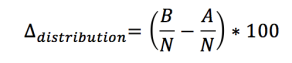
Figure 6. Calculation of changes in the distributional pattern, where A is the number of spatial units (sub-areas, grid cells) in an assessment unit occupied by seals during reference period A; B is the number of units occupied in a subsequent period B, and N is the total number of spatial units within the assessment unit. For the present assessment, period A is 2003 to 2008 and period B is 2009 to 2014.
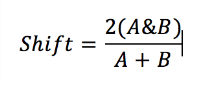
Figure 7. Calculation of shift index, where A is the number of spatial units (sub-areas, or grid cells) occupied by seals during reference period A; B is the number of units occupied in a subsequent period. For the present assessment, period A is 2003 to 2008 and period B is 2009 to 2014.
A similar set of thresholds was suggested for seal distribution, but as meaningful changes in seal distribution are currently difficult to detect and assess from abundance surveys, this aspect of the indicator will be considered a ‘surveillance indicator’, with the metric(s) described but not quantitatively assessed against a threshold.
These species are also assessed under the Habitat Directive Article 17 reporting in 2013 (European Commission, 2013).
Results
Findings from the 2012 UK Initial Assessment
Harbour seal numbers had declined significantly, by more than 50 % since 2001, in Shetland, Orkney and the East Coast of Scotland (HM Government, 2012). There had been a smaller decline in the Outer Hebrides while numbers on the West Coast of Scotland had remained relatively stable (HM Government, 2012). The causes of these localised declines were unknown. Elsewhere, harbour seal numbers had increased. In contrast and following the end of culling in the 1970s, the grey seal population had continued to increase annually (HM Government, 2012). However, pup production appeared to be stabilising, with only a small number of colonies still showing evidence of continued increases.
Latest Findings
Harbour seal status assessment
In the Greater North Sea, harbour seal abundance has increased over both the short-term (2009 to2014) and long-term (1994 to 2014) in the English Channel all assessment units along the coast of continental Europe and along the East Coast of England (Figure 8). Short and long-term declines in abundance exceeded the thresholds in East Scotland (assessment unit 8), North Coast and Orkney (assessment unit5), and Shetland (assessment unit 6), but were inconclusive in the Moray Firth (assessment unit 7). The causes of these declines are currently unknown and are the subject of a major research initiative in Scotland.
In the UK parts of the Celtic Seas there were insufficient data to conduct assessments in most assessment units (Figure 8). In West Scotland (assessment unit 3), which holds over 20 % of harbour seals in the total area of the Greater North Sea and Celtic Seas being assessed, numbers have increased substantially since 1994. In the Western Isles (assessment unit 4) and Northern Ireland (assessment unit 1) numbers have decreased since 1992 but have not conclusively exceeded thresholds. The most recent count in 2012 for the Western Isles was the highest since 1997, suggesting harbour seal numbers in assessment unit 4 are recovering.
Harbour seal occupancy (the presence of harbour seals) of haul-out sites has either increased or remained the same in most assessment units in the Greater North Sea and the UK parts of the Celtic Seas. A notable exception is in East Scotland (assessment unit 8) where abundance has declined dramatically since the mid-2000s, and the number of occupied areas has changed from seven out of a total of nine surveyed in the period 2003 to 2008- to four out of six surveyed in the period 2009 to 2014.
Harbour seal trend assessment
The UK target for harbour seal in the Greater North Sea has not been met and is uncertain for the Celtic Seas.
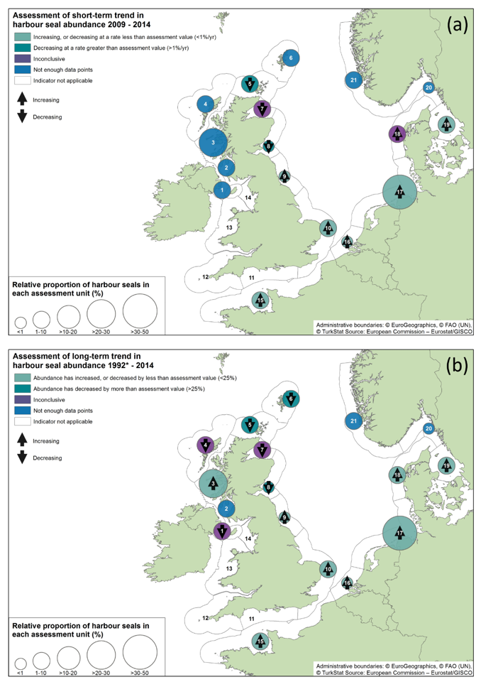
Figure 8. Assessment of changes in harbour seal abundance: (a) short-term trend (2009 to2014) assessed against no decline of more than 1% per year; and (b) long-term trend (*1992 to 2014), assessed against no decline of more than 25 %. *1992 was used as a baseline year, but in some assessment units a later year was used due to data availability.
Grey seal status assessment
Grey seal abundance in the Greater North Sea and in the UK parts of the Celtic Seas has increased since 1992. Changes in the number of grey seal breeding colonies occupied (. distributional change) between 2003 and 2008 and 2009 to 2014 were generally positive, or unchanged.
Grey seal trend assessment
The UK target has been met in both Marine Strategy Framework Directive sub-regions.
There is a moderate/low confidence in the methodology used and moderate confidence in the availability of data.
Further information
Harbour seal
Annual change in harbour seal abundance during this time ranged from -10 % per year on the North Coast and Orkney to + 9 % per year in South East England (Table 3). In general, abundance in assessment units on the North Eastern Coasts of Scotland appears to be in decline whereas on the West Coast and South East Coasts of the UK, harbour seal numbers are increasing or have remained stable (Figures 9 and 10). These results are similar to those found in more detailed analyses of harbour seal surveys in the UK (Lonergan and others, 2007; 2011; Hanson and others, 2015).
Table 3. Changes in harbour seal in abundance and distribution from surveys of haul-outs during the harbour seal moult (in August) in each assessment unit. Superscripts on numeric results indicate assessment result: (*)indicator not applicable – too few seals present, (**)not enough data points, (+)decline less than threshold, (ǁ)Decline greater than threshold, (ǂ)inconclusive (CI spans threshold). ‘Growth rate2009-2014’ is the annual growth (%) in counts between 2009 and 2014. ‘T2: Δbaseline’ is the change in numbers since the baseline year. Upper and lower 80% confidence limits are given for both parameters based on modelled growth rates (denoted upperCIT1, lowerCIT1, and upper CIT2, lowerCIT2 respectively). ‘YearsT1’ and ‘YearsT2’ are the number of years of count data in the periods 2009 to 2014 and 1992 to 2014, respectively. The observed change in numbers since the baseline, not from modelled data, is given in the column ‘Observed Δbaseline’. ‘Baseline year’ is1992 or the start of the time-series. 'Most recent count’ is the final year of available counts in the time-series. ‘Δoccupancy’ is the change in occupancy of subareas between the periods 2003 to 2008 and 2009 to 2014. This is marked as increasing (↑) if the index is greater than 10 %, decreasing (↓) if the index is negative and less than – 10 %, or no change (↔). The change in the number of sub-areas surveyed between the periods 2003 to 2008 and 2009 to 2014 given in the survey effort column. Shift index describes shifts in a distributional pattern within an Assessment Unit. a Not a population: animals seen here are likely visitors from other areas. b Distribution metrics do not include data from German sub-areas: no spatial sub- areas were defined.
|
Sub-Region |
Assessment Unit |
T1: Growth rate 2009-2014 |
upperCIT1 |
lowerCIT1 |
YearsT1 |
T2: Δ baseline |
upperCIT2 |
lowerCIT2 |
Observed Δbaseline |
|
Greater North Sea |
5.North Coast & Orkney |
-10ǁ |
-8ǁ |
-12ǁ |
4ǁ |
-74ǁ |
-70ǁ |
-78ǁ |
-76ǁ |
|
6. Shetland |
** |
** |
** |
1** |
-55ǁ |
-44ǁ |
-64ǁ |
-51ǁ |
|
|
7. Moray Firth |
-3ǂ |
3ǂ |
-9ǂ |
6ǂ |
-36ǂ |
-22ǂ |
-48ǂ |
-40ǂ |
|
|
8. East Scotland |
-8ǁ |
-6ǁ |
-10ǁ |
6ǁ |
-76ǁ |
-68ǁ |
-82ǁ |
-75ǁ |
|
|
9. Northeast England |
9 |
10 |
8 |
6 |
54 |
83 |
30 |
88 |
|
|
10. Southeast England |
4 |
6 |
3 |
6 |
78 |
95 |
62 |
68 |
|
|
11. South England |
* |
* |
* |
1* |
* |
* |
* |
* |
|
|
Celtic Seas |
12. Southwest England |
* |
* |
* |
* |
* |
* |
* |
* |
|
13. Wales |
* |
* |
* |
1* |
* |
* |
* |
* |
|
|
14. Northwest England |
* |
* |
* |
1* |
* |
* |
* |
* |
|
|
1. Northern Ireland |
** |
** |
** |
2** |
-22ǂ |
-15ǂ |
-28ǂ |
-25ǂ |
|
|
2. Southwest Scotland |
** |
** |
** |
0** |
** |
** |
** |
** |
|
|
3. West Scotland |
** |
** |
** |
2** |
34+ |
71+ |
6+ |
58+ |
|
|
4. Western Isles |
** |
** |
** |
1** |
-12ǂ |
21ǂ |
-35ǂ |
18ǂ |
|
Sub-Heading |
Assessment Unit |
YearsT2 |
Baseline year |
Most recent count |
Relative size |
Δoccupancy |
|
Greater North Sea
|
5.North Coast & Orkney |
10ǁ |
1993 |
1938 |
0.030 |
← → |
|
6. Shetland |
5ǁ |
1993 |
3039 |
0.047 |
← → |
|
|
7. Moray Firth |
15ǂ |
1994 |
733 |
0.011 |
↑ |
|
|
8. East Scotland |
14ǁ |
1997 |
194 |
0.003 |
↓ |
|
|
9. Northeast England |
20 |
1994 |
90 |
0.001 |
||
|
10. Southeast England |
19 |
1995 |
4681 |
0.073 |
||
|
11. South England |
3* |
1997 |
20 |
0.000 |
||
|
Celtic Sea
|
12. Southwest England |
* |
|
|
|
|
|
13. Wales |
3* |
1997 |
5 |
0.000 |
||
|
14. Northwest England |
3* |
1997 |
10 |
0.000 |
||
|
1. Northern Ireland |
6ǂ |
2002 |
948 |
0.015 |
||
|
2. Southwest Scotland |
3** |
1996 |
834 |
0.013 |
||
|
3. West Scotland |
6+ |
1997 |
13878 |
0.216 |
← → |
|
|
4. Western Isles |
7ǂ |
1992 |
2739 |
0.043 |
← → |
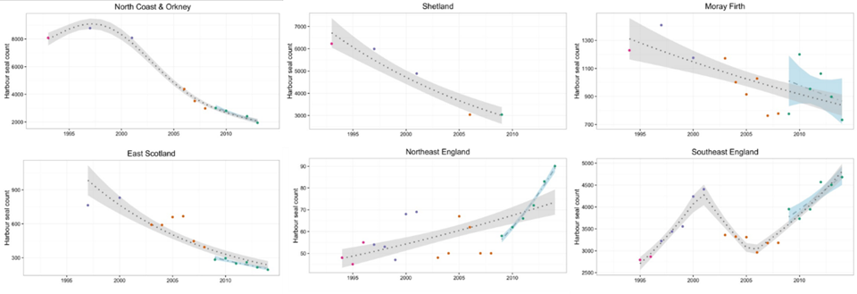
Figure 9. Trends in harbour seal abundance from surveys of haul-outs during the harbour seal moult (in August) in each Greater North Sea assessment unit. Points denote observed numbers of seals, coloured according to 4 periods from 1992 to 2014: 1992 to 1996 (pink), 1997 to 2002 (purple), 2003 to 2008 (orange), 2009 to 2014 (green). Modelled trends in annual abundance are shown for the period from the start of the time-series (baseline year) to 2014 (dash line) and 2009 to 2014 (dotted and dashed line); the 80 % confidence interval around each trend is shown as a greyed area on the plot
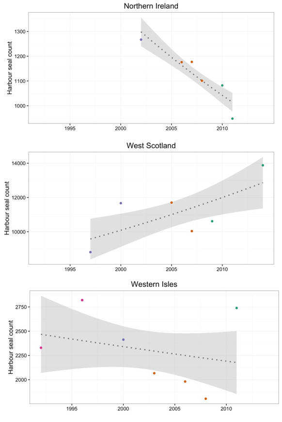
Figure 10. Trends in harbour seal abundance from surveys of haul-outs during the harbour seal moult (in August) in each Celtic Seas assessment unit. Points denote observed numbers of seals, coloured according to 4 periods from 1992 to 2014: 1992 to 1996 (pink), 1997 to 2002 (purple), 2003 to 2008 (orange), 2009 to 2014 (green). Modelled trends in annual abundance are shown for the period from the start of the time-series (baseline year) to 2014 (dash line) and 2009 to 2014 (dotted and dashed line); the 80 % confidence interval around each trend is shown as a greyed area on the plot
Grey seal
The population model predicted that the grey seal population in the Greater North Sea and Celtic Seas is currently growing (Figure 11). When the summer population estimate (2008) is included in the model, the rate of growth is far slower (Figure 11, left panel). This first run of the model is encouraging, but the modelling approach needs further refinement. Both the short and long-term thresholds indicated there had been no decline, using either modelling approach (Table 4). The estimate from the population model is based on pup production data and an independent estimate derived from summer counts of grey seal adults. These are combined to produce the trend in the right panel of Figure 11(without independent estimate). Because the uncertainty around the summer population estimate (2008 value) is much smaller than that around the population estimate from the pup model, the summer population estimate is more heavily weighted, and hence the combined model (Figure 11, left panel) is much closer to the summer population estimate than the original population model prediction. Changes in the number of colonies occupied by breeding grey seals were stable where the animals occur, and such data were available (Table 5).
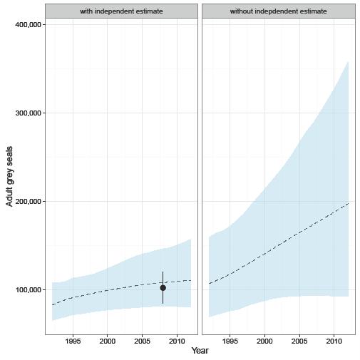
Figure 11. Predicted trends in grey seal abundance in the Greater North Sea (excluding Norway) and UK parts of Celtic Seas combined. Left panel: mean trend (dashed line) predicted from a model derived from data on pup production at grey seal colonies, combined with the 2008 summer population estimate (shown as a point with 95 % confidence interval), derived from counts of grey seals hauled out during harbour seal moult surveys. Right panel: mean trend predicted from a model derived from data on pup production alone. Shaded areas indicate 95% confidence intervals of mean trends.
Table 4. Changes in grey seal abundance in the Greater North Sea and UK parts of Celtic Seas combined, based on surveys of grey seal haul-outs during the harbour moult (in August) and on pup production at grey seal colonies (autumn/winter). All data represent “decline less than threshold. See Table 3 caption for more details.
|
Assessment Unit |
T1: Growth rate 2009-2014 |
YearsT1 |
T2: Δ baseline |
Baseline year |
Baseline year |
|
Greater North Sea and Celtic Seas |
2 |
6 |
94 |
1992 |
207111 |
|
Greater North Sea and Celtic Seas – with independent estimate |
0 |
6 |
35 |
1992 |
111504 |
Table 5. Changes in the distribution of grey seal breeding colonies in each assessment unit. Δoccupancy is the change in occupancy of subareas between the periods 2003 to 2008 and 2009 to 2014. This is marked as increasing (↑) if the index is greater than 10%, or decreasing (↓) if the index is negative and less than -10%; or otherwise, no change (↔). The change in the number of sub-areas surveyed between the periods 2003 to 2008 and 2009 to 2014 is denoted by survey effort. Shift index describes shifts in a distributional pattern within an assessment unit. Assessment units denoted with * contained too few grey seals to conduct an assessment.
|
Sub-region |
Assessment Unit |
Δoccupancy |
Survey effort |
||
|
Greater North Sea |
5.North Coast & Orkney |
← → |
1 |
||
|
6. Shetland |
← → |
-3 |
|||
|
7. Moray Firth |
← → |
0 |
|||
|
8. East Scotland |
← → |
0 |
|||
|
9. Northeast England |
← → |
0 |
|||
|
10. Southeast England |
← → |
0 |
|||
|
11. South England* |
|||||
|
Celtic Seas |
12. Southwest England* |
||||
|
13. Wales* |
|||||
|
14. Northwest England* |
|||||
|
1. Northern Ireland* |
|||||
|
2. Southwest Scotland* |
|||||
|
3. West Scotland |
← → |
2 |
|||
|
4. Western Isles |
← → |
1 |
|||
Integration of harbour seal assessment across spatial regions
The integration of harbour seal trends across assessment units for the Greater North Sea indicated that the target had not been met (Table 6). For the Celtic Seas, the results were concluded as uncertain (Table 7).
Table 6: Integration of assessment unit trends for Greater North Sea.
|
Assessment Unit |
Assessment summary |
Integration score |
August count for 2014 |
|
5. North Coast & Orkney |
Long-term and short-term declines |
-3 |
1,938 |
|
6. Shetland |
Long-term decline |
-2 |
3,039 |
|
7. Moray Firth |
Inconclusive long and short-term declines |
-1.5 |
733 |
|
8. East Scotland |
Long-term and short-term declines |
-3 |
194 |
|
9. Northeast England |
Long-term and short-term increases |
3 |
90 |
|
10. Southeast England |
Long-term and short-term increases |
3 |
4,681 |
|
11. South England |
Indicator not applicable |
- |
20 |
|
Average across Greater North Sea |
-0.58 |
|
|
Table 7. Integration of Assessment Unit trends for the Celtic Seas.
|
Assessment Unit |
Assessment summary |
Integration score |
Best available count for 2014 |
|
12. Southwest England |
Indicator not applicable |
- |
- |
|
13. Wales |
Indicator not applicable |
- |
5 |
|
14. Northwest England |
Indicator not applicable |
- |
10 |
|
1. Northern Ireland |
Inconclusive long- term decline |
-1 |
948 |
|
2. Southwest Scotland |
insufficient data |
0 |
834 |
|
3. West Scotland |
Long-term increase |
2 |
13,878 |
|
4. Western Isles |
Inconclusive long- term decline |
-1 |
2,739 |
|
Average across Celtic Seas |
0 |
|
|
Conclusions
The UK target for abundance was met for grey seals across their range in the Celtic Seas and Greater North Sea, where they have increased in number.
The UK target for harbour seal abundance in the Greater North Sea has not been met. In the Celtic Seas, the conclusion was ‘unknown’. Harbour seal abundance thresholds were met in West Scotland (Celtic Seas) and in the English part of the North Sea, where numbers are stable or increasing. Thresholds were not met in the Scottish part of the North Sea (East Scotland, Orkney, and Shetland), where harbour seal abundance has shown a marked and prolonged decline. A major research initiative is underway in Scotland to investigate the potential causes of the decline. While the causal mechanisms for the decline have not been identified, several factors have been ruled out as primary causes: fisheries bycatch, pollution, loss of habitat, entanglement in marine debris and legal shooting. The research will continue into the remaining potential cause. These may include predation (by grey seals and killer whales), competition with grey seals, and exposure to toxins from harmful algae. Elsewhere, the assessment of harbour seal abundance was inconclusive.
Further information
The relationship between seal declines and human activities is unclear. In those areas where marked and prolonged declines have been detected (for example: Orkney, Shetland, East Scotland; Lonergan and others, 2007; 2013; Special Committee on Seals, 2014; Hanson and others, 2015) a major research initiative is already in place to identify and quantify the demographic parameters driving the change and to investigate potential causes (Arso Civil and others, 2016, 2017). Another consideration is the historical and present dynamic between the two seal species, which have considerably overlapped coastal and at-sea distributions. In some areas, the present abundance of harbour seals may be higher, in part, because historical hunting pressure on grey seals drove some local populations to extinction, potentially reducing the competitive pressure on harbour seals. As grey seal populations recover, harbour seals may face increased competitive pressure from grey seals that could have a detrimental effect on their abundance. It is also thought that grey seals may be predating harbour seals, as has been observed in continental Europe (Special Committee on Seals, 2015; Van Neer and others, 2015). While direct effects of human activities (such as hunting) on seal population growth has been greatly reduced or removed in most areas, other human pressures such as pollution and underwater noise could impact future growth by determining the level of carrying capacity.
Knowledge gaps
Determining the impact of human pressure is key to assessing progress against the UK target and to undertaking appropriate management if the target is not met. In Scotland, strandings of both species are monitored, and cause of death is determined., In Northern Ireland there is a targeted seal post-mortem programme in cases of suspicious deaths. There is currently no such monitoring of strandings in England and Wales. Such monitoring can be used to identify the causes of population change. It can help to distinguish natural causes such as disease epidemics caused by the Phocine Distemper Virus along with anthropogenic causes including illegal shooting, fisheries bycatch, and pollution.
Further information
The estimates of grey seal population size and trajectories from the Bayesian population model are preliminary. By combining data across different areas and monitoring programmes two key assumptions can be made: (1) the proportion of grey seals hauled out during the August survey windows does not vary geographically and (2) peak pup counts can be scaled to production using a single scalar based on UK data. In reality, the value of this scalar will depend on factors such as whether the true peak count was observed and the shape of the pup production. For assumption (1) the only published proportion estimate available is based on UK telemetry data. Other telemetry datasets (France, Ireland, Netherlands, Denmark) could be examined to refine this assumption.
It is possible that haul-out habitat (substrate) could influence haul-out behaviour and it would be important to incorporate this into the model. In addition, the estimates produced by the model are sensitive to the prior distributions inputted into the model (Special Committee on Seals-BP 14/02). ‘Priors’ are probability distributions used in Bayesian statistical models that describe parameters before evidence is taken into account. The priors that have been found to be most appropriate for the UK grey seal population model (Special Committee on Seals-BP 14/02) were used here with the exception of the movement parameters, which are not in the current UK population model. Further model runs with different priors on these parameters will ensure that the population predictions are robust to changes in the priors on the movement parameters.
The grey seal population appears to still be increasing. It is likely that the population is recovering from a time when populations were significantly depleted by human activities. Hunting, pollution, and overfishing are all likely to have reduced populations in the 20th- century. Although an increase in grey seal abundance can be seen as a positive sign, this does not indicate that there are no anthropogenic (fisheries by-catch, resource competition, noise, habitat loss, disturbance, pollutants) pressures, only perhaps that there is less pressure than there was previously. More research is needed if direct links between population and human activities are to be established. Even with no pressure from human activities, it is clear that the grey seal population cannot increase indefinitely as a growing population will eventually near its natural carrying capacity. What this carrying capacity might be for grey seals, or what the consequences of population changes will be for harbour seals, are both unknown.
Power to detect the growth rate specified in threshold 1 (-1% per year) was retrospectively calculated using the formulae from Thomas (1997) where λ (the non-centrality parameter) is a function of the specified effect size (here, the assessment growth rate is of -1 % per year), the sum of squares and variance estimated from the fitted model. The total sample size was calculated as the product of the number of years of survey data and the typical number of replicate surveys performed in the assessment unit. Using this method, the statistical power to detect a harbour seal population rate of decline of 1 % per year was low (around 20 %) in some assessment units, especially where monitoring occurs on a less than annual basis. This threshold may need to be revised for future assessments or monitoring programmes improved to enhance the power to detect trends. In the present assessment, the confidence intervals provide a robust assessment of uncertainty regarding the magnitude of observed trends.
Both distribution metrics are sensitive to the number of spatial units defined within each assessment unit by the Contracting Party. In an assessment unit with relatively few total subdivisions, the absence of animals in one subdivision will equate to a large change in occupancy (Δoccupancy) between the reporting periods. Additionally, variation in survey effort between reporting period can confound assessment of this metric. For example, there is no systematic monitoring of seals in Wales. Only a few colonies (Skomer and Bardsey) are monitored annually, with the last census occurring in 2004 for North Wales and 2006 for North Pembrokeshire. The UK wide survey needs to include Wales, noting that approximately 50 % of grey seal pupping occurs in caves and is therefore undetectable by aerial observations.
References
Arso Civil M, Smout S, Duck C, Morris C., Onoufriou J, Thompson D, Brownlow A, Davison N, C, Cummings C, Pomeroy P, McConnell B and Hall A J (2016) ‘Harbour seal decline – vital rates and drivers – Annual Report, Year 1. Sea Mammal Research Unit Report to Marine Scotland, Scottish Government’ Sea Mammal Research Unit, Scottish Oceans Institute, University of St Andrews, St Andrews, UK (viewed on 9 November 2018)
Arso Civil M, Smout S, Thompson D, Brownlow A, Davison NC, Doeschate, M, Duck C, Morris C, Cummings C, McConnell B and Hall AJ (2017) ‘Harbour seal decline – vital rates and drivers – Annual Report, Year 2’ Sea Mammal Research Unit Report to Marine Scotland, Scottish Government. Sea Mammal Research Unit, Scottish Oceans Institute, University of St Andrews, St Andrews, UK (viewed on 9 November 2018)
Brasseur S, van Polanen Petel T, Gerrodette T, Meesters E, Reijnders P, Aarts G (2015) ‘Rapid recovery of Dutch grey seal colonies fuelled by immigration’ Marine Mammal Science, 31: 405-426 (viewed on 9 November 2018)
European Commission (2013) ‘Habitat Directive reporting Article 17 reporting (progress report)’ (viewed on 9 November 2018)
Fortin M, Keitt T, Maurer B, Taper M, Kaufman D, Blackburn T (2005) ’Species’ geographic ranges and distributional limits: pattern analysis and statistical issues’ Oikos, 108: 7-17 (viewed on 9 November 2018)
Goodman S (1998) ‘Patterns of extensive genetic differentiation and variation among European harbor seals (Phoca vitulina vitulina) revealed using microsatellite DNA polymorphisms’ Molecular Biology and Evolution, 15: 104-118 (viewed on 9 November 2018)
Hanson N, Thompson D, Duck C, Baxter J, Lonergan M (2015) ‘Harbour seal (Phoca vitulina) abundance within the Firth of Tay and Eden Estuary, Scotland: recent trends and extrapolation to extinction’ Aquatic Conservation: Marine and Freshwater Ecosystems doi: 10.1002/aqc.2609 (viewed on 9 November 2018)
Humphreys EM, Austin GE, Thaxter C, Johnston A, Risely K, Frederiksen M and Burton NHK (2015) Development of MSFD Indicators, Baselines, and Targets for Population Size and Distribution of Marine Birds in the UK. Report to JNCC. JNCC, Peterborough 2015.
ICES (2014a) ‘OSPAR request on the implementation of MSFD for marine mammals’ ICES Advice 2014 Book 1: 1.6.6.1 (viewed on 9 November 2018)
ICES (2014b) ‘Report of the working group on Marine Mammal Ecology (WGMME)’ 10-13 March, 2014 Woods Hole, Massachusetts, USA. ICES CM 2014/ACOM: 27 (viewed on 9 November 2018)
Jones E, McConnell B, Sparling C, Mattiopoulos J (2013) ‘Grey and harbour seal usage maps’ Marine Mammal Scientific Support Research Programme MMSS/001/11. Currently available from http://www.scotland.gov.uk/Topics/marine/science/MSInteractive/Themes
Lonergan M, Duck C, Thompson D, Moss S, McConnell B (2011) ‘British grey seal (Halichoerus grypus) abundance in 2008: an assessment based on aerial counts and satellite telemetry’ ICES Journal of Marine Science, 68: 2201–2209 (viewed on 9 November 2018)
Lonergan M, Duck C, Thompson D, Mackey B, Cunningham L, Boyd I (2007) ‘Using sparse survey data to investigate the declining abundance of British harbour seals: Harbour seal declines’ Journal of Zoology, 271: 261-269 (viewed on 9 November 2018)
Lonergan M, Duck C, Moss S, Morris C, Thompson D (2013) ‘Rescaling of aerial survey data with information from small numbers of telemetry tags to estimate the size of a declining harbour seal population’ Aquatic Conservation: Marine and Freshwater Ecosystems, 23: 135-144 (viewed on 9 November 2018)
McConnell B J, Fedak MA, Lovell P and Hammond PS (1999) ‘Movements and foraging areas of grey seals in the North Sea’ Journal of Applied Ecology, 36: 573-590 (viewed on 9 November 2018)
Meesters E, Reijnders P, Brasseur S, Ursula S, Stede M, Tougaard S, Härkönen T (2007) ‘An effective survey design for harbour seals in the Wadden Sea: tuning the Trilateral Seal Agreement and EU-Habitat Directive requirements’ Common Wadden Sea Secretariat Trilateral Working Group, Seal Managemnet Plan: Monitoring Scheme, Document Number: TWG 07/1/5.1 SMP.
Olsen M, Andersen L, Dietz R, Teilman J, Härkönen T, Siegismund H (2014) ’Integrating genetic data and population viability analyses for the identification of harbour seal (Phoca vitulina) populations and management units’ Molecular Ecology, 23: 815-831 (viewed on 9 November 2018)
OSPAR Commission (2010) ’The OSPAR system of Ecological Quality Objectives for the North Sea, a contribution to OSPAR’s Quality Status Report 2010’ (viewed on 23 November 2018)
OSPAR Commission (2012) ‘MSFD Advice Manual and Background Document on Biodiversity’ Version 3.2. OSPAR Biodiversity Series (viewed on 11 November 2018)
Pomeroy PP, Twiss SD and Redman P (2000) ‘Philopatry, site fidelity, and local kin associations within grey seal breeding colonies’ Ethology, 106: 899-919 (viewed on 11 November 2018)
Russell D, McConnell B, Thompson D, Duck C, Morris C, Harwood J, Matthiopoulos J (2013) ‘Uncovering the links between foraging and breeding regions in a highly mobile mammal’ Journal of Applied Ecology, 2: 499-509 (viewed on 11 November 2018)
Special Committee on Seals (2014) ‘Scientific advice on matters related to the management of seal populations, 2014’ Special Committee on Seals (SCOS), Sea Mammal Research Unit (viewed on 11 November 2018)Special Committee on Seals (2015) ‘Scientific advice on matters related to the management of seal populations, 2015’ Special Committee on Seals (SCOS), Sea Mammal Research Unit (viewed on 11 November 2018)
Teilmann J, Rigét F, Härkönen T (2010) ‘Optimizing survey design for Scandinavian harbour seals: population trend as an ecological quality element’ ICES Journal of Marine Science, 67: 952-958 (viewed on 11 November 2018)
Thomas L (1997) ‘Retrospective power analysis’ Conservation Biology, 11: 276-280 (viewed on 11 November 2018)
Van Neer A, Jensen LF, Siebert U (2015) ‘Grey seal (Halichoerus grypus) predation on harbour seals (Phoca vitulina) on the island of Helgoland, Germany’ Journal of Sea Research, 97: 1-4 (viewed on 9 November 2018)
Assessment metadata
| Assessment Type | UK MSFD Indicator Assessment |
|---|---|
D1/D4/D6 Biodiversity and Food Webs, Seals | |
| Point of contact email | marinestrategy@defra.gov.uk |
| Title | Seal Abundance and Distribution |
| Resource abstract | Common indicator assessment of seal abundance and distribution. Applicable to the Greater North Sea and Celtic Seas (OSPAR Regions II and III) |
| Linkage | |
| Conditions applying to access and use | http://www.ospar.org/site/assets/files/1215/ospar_data_conditions_of_use.pdf |
| Assessment Lineage | |
| Indicator assessment results | |
| Dataset metadata | |
| Links to datasets identifiers | https://odims.ospar.org/en/submissions/ospar_seal_abundance_2017_01/ https://odims.ospar.org/en/submissions/ospar_seal_abundance_2017_02/ |
| Dataset DOI | Please, see metadata details and links above |
The Metadata are “data about the content, quality, condition, and other characteristics of data” (FGDC Content Standard for Digital Geospatial Metadata Workbook, Ver 2.0, May 1, 2000).
Metadata definitions
Assessment Lineage - description of data sets and method used to obtain the results of the assessment
Dataset – The datasets included in the assessment should be accessible, and reflect the exact copies or versions of the data used in the assessment. This means that if extracts from existing data were modified, filtered, or otherwise altered, then the modified data should be separately accessible, and described by metadata (acknowledging the originators of the raw data).
Dataset metadata – information on the data sources and characteristics of data sets used in the assessment (MEDIN and INSPIRE compliance).
Digital Object Identifier (DOI) – a persistent identifier to provide a link to a dataset (or other resource) on digital networks. Please note that persistent identifiers can be created/minted, even if a dataset is not directly available online.
Indicator assessment metadata – data and information about the content, quality, condition, and other characteristics of an indicator assessment.
MEDIN discovery metadata - a list of standardized information that accompanies a marine dataset and allows other people to find out what the dataset contains, where it was collected and how they can get hold of it.
Recommended reference for this indicator assessment
Ian Mitchell1, Nora Hanson2, Eunice Pinn1, Debbie Russell2, John Weinberg1 and Jane Hawkridge1 2018. Changes in the abundance and distribution of seals*. UK Marine Online Assessment Tool, available at: /biodiversity-food-webs-and-marine-protected-areas/seals/abundance-and-distribution/
* Adapted from OSPAR Intermediate Assessment 2017 on seal abundance and distribution
1Joint Nature Conservation Committee
2Sea Mammal Research Unit UK