Species composition in fish communities (mean maximum length)
In the Channel and the eastern Irish Sea, the health of the demersal fish community has improved since the 1990s, with an increasing contribution of species that attain a large size. In the central and southern North Sea and on the shelf edge to the west of Scotland, an imminent recovery in community health is unlikely, since the balance of species within communities, relative to the early 1980s, has shifted towards smaller species.
Background
UK Target on ecosystem structure: species composition in fish communities
This indicator is used to assess progress against the following target, which is set in the UK Marine Strategy Part One (HM Government, 2012): ”the size composition of fish communities should not be impacted by human activity”.
Key pressures and impacts
Variation in the size composition of fish communities is indicative of a change in their status, such that communities with relatively high proportions of large fish are considered ‘healthy’. This size composition is dependent on species being present that have the potential to grow to large sizes. But, over long periods of time, fishing can lead to fish communities that are dominated by relatively small species that mature earlier and grow faster. Under high fishing levels, the mean maximum length of fish should decline gradually as fish communities are restructured. A fish community that is dominated by small species has less potential to recover to become one that is ‘healthy’ with a high proportion of large-sized fish. When overfished, the transfer of mass and energy from prey species to larger predators (trophic function) is reduced. Therefore, trends in the mean maximum length indicator will reflect a corresponding decline or improvement in species composition and therefore, fish community status.
Measures taken to address the impacts
The UK Marine Strategy Part Three (HM Government, 2015) states that all parts of the marine fish community have been impacted by human activities, but there have been recent improvements in the status of some of these fish communities primarily because of a reduction in fishing pressure. With the existing policy in place and the introduction of the reformed Common Fisheries Policy, it is expected that there will be a further reduction in the overall fishing pressure reducing fishing impacts on both target and non-target species and sensitive species.
Monitoring, assessment, and regional cooperation
Areas that have been assessed
The assessment was based on data collected by 13 groundfish surveys carried out across two UK Marine Strategy Framework Directive Sub-Regions, the Greater North Sea and Celtic Seas.
Monitoring and assessment methods
The mean maximum length of fish (bony fish and elasmobranchs) provides information on the species composition within communities of fish. The indicator is calculated using data on the biomass of fish per unit swept area caught by scientific surveys and a single trait for each species: maximum recorded length of an individual observed in the entire data set. Changes in mean maximum length over time were estimated separately for demersal fish species that live on or near the sea floor and for pelagic species that live in the water column. The lack of data prior to large-scale commercial fishing means it is difficult to determine what mean maximum length values have been indicative of healthy populations of demersal and pelagic fish. The time-series of data for most areas assessed started in the 1980s or 1990s when fishing pressure had been high for a number of years. For the UK target to be met, mean maximum length would be expected to be increasing compared to earlier points in the time-series. If mean maximum length is not increasing, further investigation is required to identify if a lack of recovery in species composition of communities is due to human activities, food web interactions, or prevailing climatic conditions.
Assessment thresholds
No thresholds were set, but changes in mean maximum length were categorised as a (1) ‘long-term decrease to a minimum state’, (2) ‘long-term decrease’ (mean maximum length in the current period is lower than in an earlier period, but higher than a more recent one), (3) ‘long-term increase’ or (4) ‘no change’. The periods were identified using statistical analyses (see details in the Assessment Method section, below). Additionally, in each case, the minimum value observed over the time-series prior to the last 6-years, was considered as a lower limit that should be avoided in future.
Regional cooperation
This UK assessment has been adapted from the OSPAR Intermediate Assessment (OSPAR Commission, 2017).
stuff
Further information
The justification for the indicator
The intensive exploitation of marine fish has led to substantial reductions in the abundance of some target species (Myers and others, 1996) and changes in the structure and species composition of fish communities (Greenstreet and Hall, 1996). Specifically, large or slow-growing species with late maturity (Adams, 1980; Roff, 1984; Kirkwood and others, 1994) often decline in abundance more rapidly than their smaller and faster-growing counterparts. Indeed, many large or slow-growing species have become scarce following intensive exploitation, even when they are not primary targets of the fishery (Brander, 1981; Vince, 1991; Walker and Heessen, 1996; Jennings and Kaiser, 1998; Sutherland and Reynolds, 1998). It was only after Jennings and others (1998) performed an analysis based on phylogenetic comparisons that it became evident that the differential effects of fishing on individual species were driven by their contrasting life histories because these eliminate many spurious differences among unrelated taxa (Harvey, 1996).
Jennings and others (2001) showed that examination of a relatively simple component of life history, such as maximum length, can indicate the response to fishing. Thus, an a priori prediction of the susceptibility of fish species (exploited and unexploited) can be made using data that are widely available and without recourse to complex studies of population dynamics.
Maximum length as used for this indicator is represented by the maximum size observed in the assessed surveys, which seems to be closely correlated with the asymptotic length (denoted L∞ or Linf) as emerges from the Von Bertalanffy growth curve (von Bertalanffy, 1957; Figure 1). The indicator is calculated for spatial sub-divisions appropriate to communities and pressures that can be localised and aggregated at the regional scale (in this case aligning with the Sub-Regions defined for the Marine Strategy Framework Directive; European Commission, 2008a).
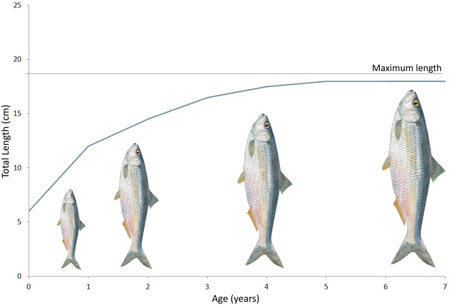
Figure 1. Maximum length based on the von Bertalanffy growth curve.
The mean maximum length indicator of species composition is used with the UK indicators of size composition in fish communities (typical length) and the proportion of large fish (Large Fish Index) to assesses progress towards the UK target on ecosystem structure in fish (fish community structure). The maximum length indicator reflects the change in species composition only, while typical length reflects the change in size structure and the Large Fish Index shows the community level response to fishing pressure, once tailored towards large individuals.
The UK target assumes that variation in the size composition of fish communities is indicative of a change in their status, such that communities with relatively high proportions of large fish are considered ‘healthy’. The Large Fish Index measures the proportion of large fish in the demersal fish community, and the typical length measures the size composition in both demersal and pelagic communities. A high or increasing Large Fish Index is indicative of a healthy or recovering demersal fish community. A demersal community with low Large Fish Index will consist mainly of small fish and is indicative of an over exploited community. The maximum length indicator indicates the potential for the size structure (typical length) and proportion of large fish in the community to increase. If the community also has a low maximum length indicator, then the Large Fish Index of that community is unlikely to recover in the short or medium-term, and the size structure of that community (it’s typical length) should be evaluated against this potential. But if the community has a high maximum length indicator, with strong recruitment events detectable in the typical length indicator, then the Large Fish Index I is more likely to recover with appropriate management. In such a case, fishing will have removed older, larger fish; creating a community dominated by younger, smaller fish. But the high maximum length indicator means that species are present that have the potential to grow large. Remedial management will allow young individuals of these species to grow larger, become mature and contribute to future generations.
Greenstreet and others (2012) showed that the maximum length indicator correlates with another species composition indicator: biodiversity evenness metrics. Some overlap can be expected with the indicator on recovery in the population abundance of sensitive fish species because the species included in that indicator are selected based on their sensitivity to fishing, determined by life-history parameters that are strongly correlated with maximum length (ICES, 2016). However, because the maximum length indicator reflects a change in relative biomass within fish communities (pelagic and demersal), it is complementary to measure absolute species abundance arising from sensitive species.
Assessment method
Indicator Metric
Mean maximum length can be calculated for the entire assemblage caught by a particular gear or a subset based on morphology, behaviour or habitat preferences (for example, bottom-dwelling species only). Mean maximum length is calculated (ICES, 2012) as shown in Figure 2.

Figure 2. Equation for the calculation of mean maximum length (MML) where Lmax j is the maximum length obtained by species j; Bj is the biomass of all individuals of species j and B is the total biomass of all individuals.
Data for this indicator come from scientific fisheries surveys, which ideally sample the entire fish community but in practice do not. Every survey can be expected to sample a survey-specific subset of the community often referred to as an assemblage. The indicator requires that each survey is conducted at regular intervals (for example, annually) in the same area with standard fishing gear. Sufficiency of sample sizes can be judged using re-sampling techniques (Shephard and others, 2012). The number of individuals per species is not always recorded directly by surveys but may be based on samples with certain detection error (including false negatives, specifically for rare species). The detection error is further complicated by differing catchabilities over length classes and species, such that the observed relative abundance between species (and size-classes) is survey-specific. Where available, catchability estimates can be used to correct for this component of the systematic measurement error (for example: Fraser and others, 2007; Walker and others, 2017). However, such estimates are sparse in the scientific literature and are prone to high uncertainty. Alternatively, model-based estimates of absolute species abundance can be used to rescale observed abundances, but here model uncertainty is also large (ICES, 2014). For simplicity, the mean maximum length indicator is therefore calculated as a survey-specific indicator without any correction for detection error (catchability). This implies that every survey-specific indicator may provide a slightly different perspective to the reality they are supposed to represent. This indicator is this calculated for each survey and, where possible, also for sub-divisional strata that are assumed to represent different habitats and communities.
The data are collected under national programmes and the Data Collection Framework (European Commission, 2008b). Currently, the most important data source for mean maximum length are those groundfish surveys that are coordinated by the International Council for the Exploration of the Sea (ICES). The International Bottom Trawl Survey programme is particularly important since the ‘Grande Overture Vertical trawl (commonly known as the GOV trawl) is a general-purpose design aimed at catching demersal and pelagic species. However, beam trawl surveys are more efficient at catching benthivorous species (such as sole, Soleidae family) and acoustic surveys, supplemented with pelagic trawling, are more suitable for pelagic species (such as mackerel, Scombridae family) and time series of mean maximum length from such surveys may be preferable should time-series of biomass of multiple species be made available.
Data used and quality assurance
This assessment draws on raw data from the ICES database of trawl surveys (DATRAS). These data have been quality controlled within OSPAR to generate a data product for assessment purposes (Greenstreet and Moriarty, 2017). Time-series of mean maximum length for fish and elasmobranchs are derived from each available groundfish and beam trawl survey, where the community is separated into demersal and pelagic habitat-based feeding guilds.
Time-series of mean maximum length by guild were determined for 13 groundfish surveys (ten using otter trawl and three using beam trawl) carried out across two separate regions: the Greater North Sea and the Celtic Seas (Table 1). Ecological sub-divisions were determined for the Greater North Sea using a simplification of those strata proposed by the EU financed project Towards a Joint Monitoring Programme for the North Sea and Celtic Sea (JMP NS/CS)” that took place in 2013, and building upon work of the EU project “Vectors of change in European Marine Ecosystems and their Environmental and Socio-Economic Impacts” that examined the significant changes taking place in European Seas, their causes, and the impacts they will have on society.
Standard data collected on these surveys comprise numbers of each species of fish sampled in each trawl sample, measured to defined length categories (1 cm below, so a fish with a recorded length of 14 cm would be between 14.00 and 14.99 cm in length). By dividing these species catch numbers-at-length by the area swept by the trawl on each sampling occasion, catch data are converted to standardised estimates of fish density-at-length (referred to below as catch-per-unit-area), by species, at each sampling location. Summing these trawl-sample species density-at-length estimates across all trawl samples collected within each sampling stratum in each year (survey-specific strata following the survey design, which are ICES statistical rectangles in the Greater North Sea and generally depth-based strata elsewhere).
Table 1. List of groundfish surveys, a region in which they operate, and the period over which they have been undertaken. The survey acronym naming convention consists of (1) first 2–3 capitalised letters indicate the region (CS: Celtic Seas; GNS: Greater North Sea), (2) subsequent capitalised and lowercase letters indicate the country involved (Fra: France; Eng: England; Ire: Republic of Ireland; NIr: Northern Ireland; Sco: Scotland; Ger: Germany; Int: International ICES North Sea bottom trawl survey; Net: Netherlands), (3) two capitalised letters indicate the type of survey (OT: otter trawl; BT: beam trawl), (4) final number indicates the season in which the survey is primarily undertaken (1: January to March; 3: July to September; 4: October to December). *Survey CSFraOT4 is a single survey that operates in the Celtic Seas and the Bay of Biscay and Iberian Coast regions, from the southern coast of the Republic of Ireland and down the western Atlantic Coast of France and was split into its two regional components for the purposes of the Large Fish Index assessment.
|
Sub-region |
Survey Accronym1 |
Survey Period |
|
Celtic Seas (including OSPAR Wider Atlantic) |
CSFraOT4* |
1997 – 2015 |
|
CSEngBT3 |
1993 – 2015 |
|
|
CSIreOT4 |
2003 – 2015 |
|
|
CSNIrOT1 |
1992 – 2015 |
|
|
CSNIrOT4 |
1992 – 2015 |
|
|
CSScoOT1 |
1985 – 2016 |
|
|
CSScoOT4 |
1995 – 2015 |
|
|
WAScoOT3 |
1999 – 2015 |
|
|
Greater North Sea |
GNSEngBT3 |
1990 – 2015 |
|
GNSFraOT4 |
1988 – 2015 |
|
|
GNSIntOT1 |
1983 – 2016 |
|
|
GNSIntOT3 |
1998 – 2016 |
|
|
GNSNetBT3 |
1999 – 2015 |
Where multiple surveys were available for assessment, key surveys were prioritised given the length of time series available and spatial coverage of the regional sea in question. If these measures were equal between surveys, then whichever surveyed the greatest biomass by assemblage was selected as key for indicator assessment. Where disagreement between surveys exists in the survey area, these are described in the text. The following surveys were considered key:
Greater North Sea
GNSIntOT1 for both demersal and pelagic assemblages was selected as the key survey (preferred) for the Greater North Sea, given that it is the longest survey with the best spatial coverage. For the eastern English Channel, GNSEngBT3 was preferred for demersal assemblage given more consistent sampling here than GNSIntOT1 and GNSFraOT4. GNSFraOT4 was preferred for the pelagic assemblage in the eastern English Channel given the length of time series available.
Celtic Seas
CSScoOT1 for both demersal and pelagic assemblages was preferred over CSScoOT4 and CSIreOT4 due to the length of the time series. CSIreOT4 for both demersal and pelagic assemblages was preferred for sub-divisions to the west of Ireland and in the northern Celtic Sea, but not in the north where there was overlap with CSScoOT1. CSFraOT4 for both demersal and pelagic assemblages was preferred in the southerly sub-divisions of the Celtic Sea, except where overlap occurred with CSIreOT4.
CSEngBT3 for the demersal assemblage was preferred for the Irish Sea over CSNIrOT1 and CSNIrOT4 given its greater spatial coverage (inclusion of the St Georges Channel stratum to the south of the Irish Sea throughout the time-series). However, as a beam trawl survey CSEngBT3 catches flatfish species such as sole and plaice in preference to roundfish such as cod and haddock. CSNIrOT1 was chosen for the pelagic assemblage was preferred for the Irish Sea over CSNIrOT4 given relatively high biomass of the assemblage caught and identical coverage spatially and temporally.
Trend analysis
In each case, the minimum value observed over the time-series, prior to the last six years, was considered as a lower limit that should be avoided in the future. The long-term trend in each time series (sub-division and survey level) was modelled through the application of a locally weighted scatterplot smoothing with a simple ‘fixed span’ of one decade, and breakpoint analyses were used to define stable underlying periods.
Breakpoint analyses used data to define stable underlying periods (Probst and others, 2015). The method makes it possible to say whether there is a significant change in the indicator over time, that is, whether a specific period is not significantly different from the historically observed period. The method avoids the arbitrary choice of reference periods for assessment (in other words, how many years to choose to calculate an average), which can lead to subjective assessments. The shorter the period chosen, the more likely it is to be comparing noise in the data or natural fluctuations in the system against each other. However, too long a period and the actual changes in the indicator might be averaged out. The minimum detectable period is defined in this analysis as three years. The analysis uses two statistical approaches: (1) applying the ‘supremum F test’ to identify if a non-stationary time series or if a constant period for the entire time series is more suitable; (2) if considered non-stationary, then breakpoint analysis finds periods of at least three-years in duration.
Results
Findings from the 2012 UK Initial Assessment
This indicator was not considered as part of the UK Initial Assessment (HM Government, 2012).
Latest findings
Greater North Sea
Within the Greater North Sea, the mean maximum length of demersal fish and pelagic fish communities is declining in the southern and central sub-divisions and shows no long-term change in the northern sub-divisions. (Figure 3). In the demersal fish community of the northern North Sea, an initial fall in mean maximum length during the 1980s was followed by a subsequent recovery since the mid-1990s. In contrast to the declining trends in the southern Greater North Sea, the mean maximum length of demersal fish community in the English Channel appears to be increasing.
Celtic Seas
Within the Celtic Seas, the mean maximum length of demersal fish communities has decreased along the shelf edge waters to the west and in the Clyde area, but increased in the Irish Sea, the Sea of the Hebrides and The Minch (Figure 3). For the pelagic fish community, mean maximum length has increased in the central Irish Sea, extending into the Celtic Sea but has decreased in many northerly areas to the west of Scotland.
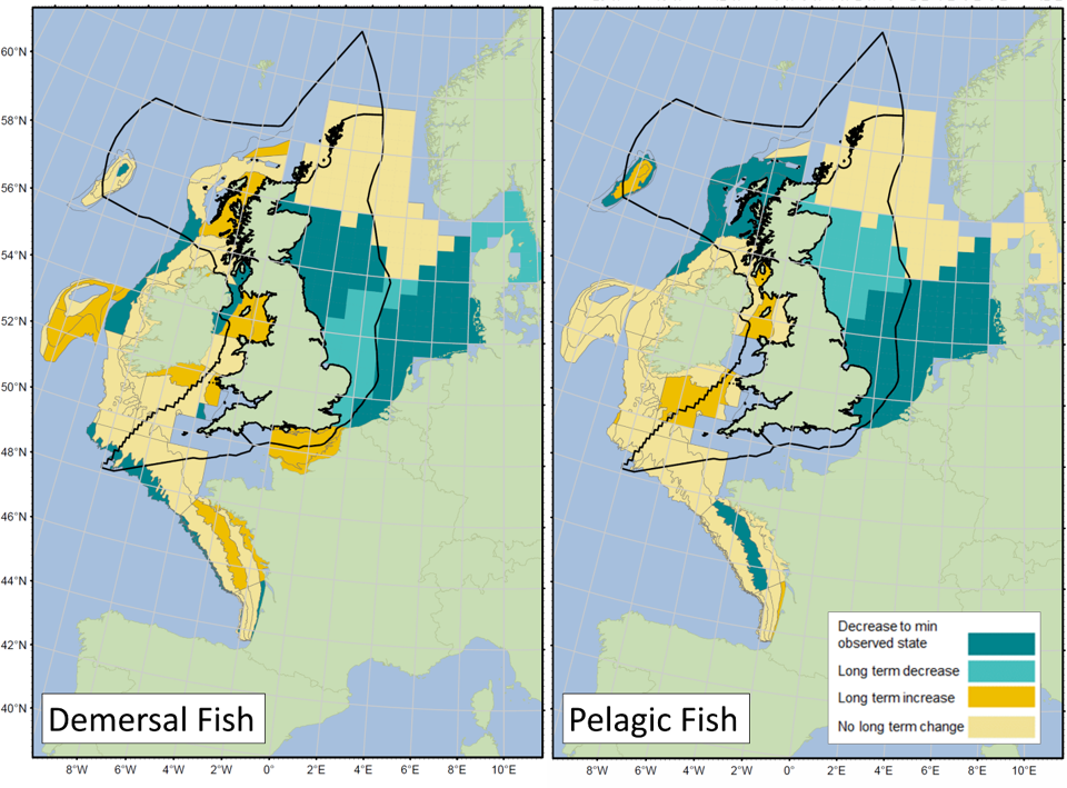
Figure 3. Summary of long-term changes in the mean maximum length of demersal fish (left) and pelagic fish (right) communities in UK waters and surrounding areas (exclusive economic zones shown by sold black line) in key surveys selected for spatial coverage (Table 1). Assessment period starts in 1980s or 1990s and ends in 2015 or 2016 depending on the survey.
Further information
Time series of mean maximum length per regional sea for demersal and pelagic fish communities based on key surveys are outlined in Figure 4. For the Greater North Sea overall, mean maximum length of both demersal and pelagic species communities, based on the most appropriate survey, has decreased over time. The eastern Channel time-series (survey GNSEngT3) shows increases in demersal fish since 1990. For the Celtic Seas, there is no clear overall trend or even a pattern over time in mean maximum length for either demersal or pelagic fish. The different surveys often show contradicting signals. However, signs of recoveries are present in some surveys to the north of the area (WAScoOT3, CSScoOT1, CSNIrOT1).
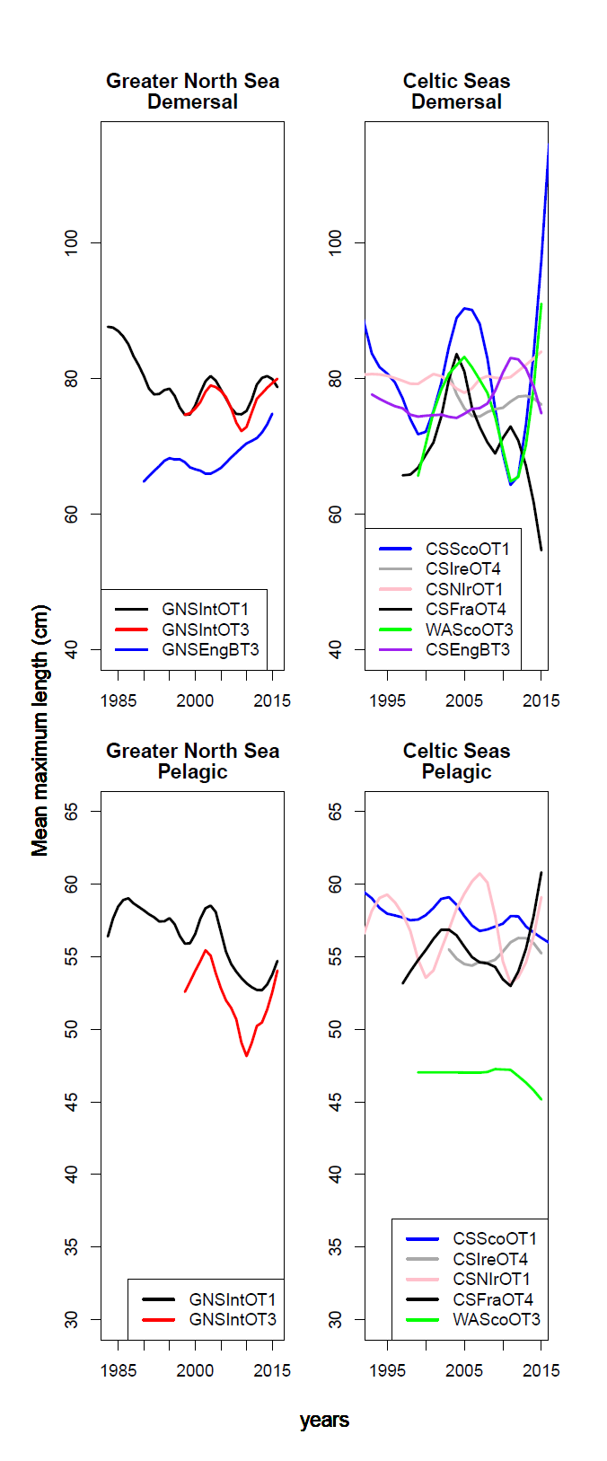
Figure 4. Time series of mean maximum length per region for demersal (upper plots) and pelagic (lower plots) fish communities.
Breakpoint analysis identified instances (surveys) where a change was observed over time. For demersal fish, this was a decrease in the Greater North Sea of 6% (GNSNetBT3) to 11% (GNSIntOT1), except for the English Channel, which showed a 7% increase (GNSEngBT3) and an increase in the Celtic Seas of 4% to 7%. For pelagic fish, this was a decrease in the Greater North Sea of 8% and a decrease in the Celtic Seas of 7% to 32%.
The summary results for each fish community (Figure 3) draw on multiple analyses for separate surveys. The individual results for surveys that sample UK waters well are shown below (Figures 5-31). A map of spatial sub-divisions is given to identify which are measured by each survey and then these are followed by time series analyses. Time series are shown for each survey sub-division and aggregated at survey level (title ‘sea’) for demersal and pelagic communities. Each subtitle in the timeseries plots shows the p value for supremum F-test, which demonstrates whether a significant long- term change is evident. The changes are shown by the red dashed lines when significant or else a mean level is shown for the whole time series using a grey dashed line. Annual estimates are shown by blue circles with a fitted locally weighted scatterplot smoothing plot (black line) with an estimate of spread shown (± one standard deviation). A solid horizontal blue line with minimum observed data point prior to the most recent six data points and two horizontal thin black lines showing the average indicator value for the first and last six years are also shown.
Greater North Sea
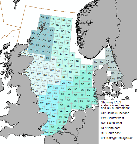
Figure 5. North Sea sub-divisions used as a basis for GNSIntOT1, GNSIntOT3, GNSNetBT3 analyses.
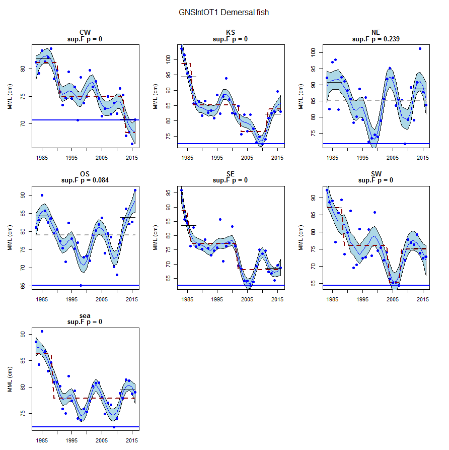
Figure 6. GNSIntOT1 demersal fish community.
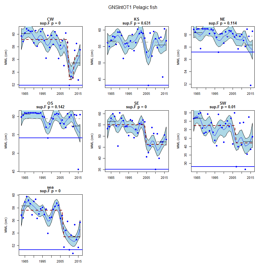
Figure 7. GNSIntOT1 pelagic fish community.
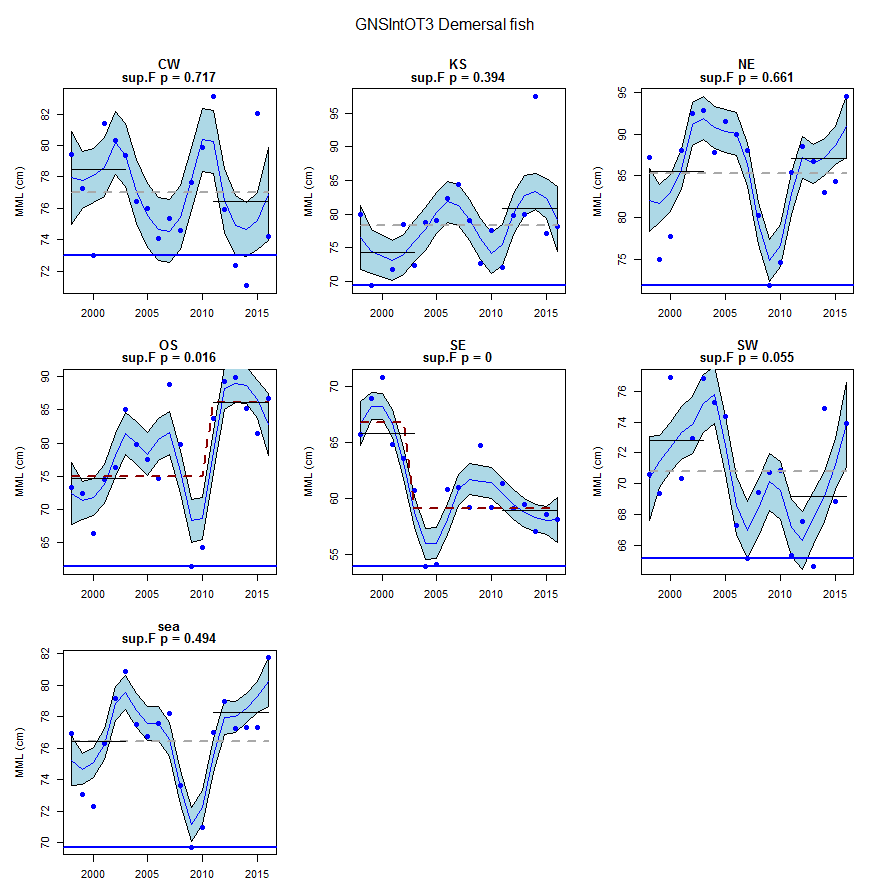
Figure 8. GNSIntOT3 demersal fish community.
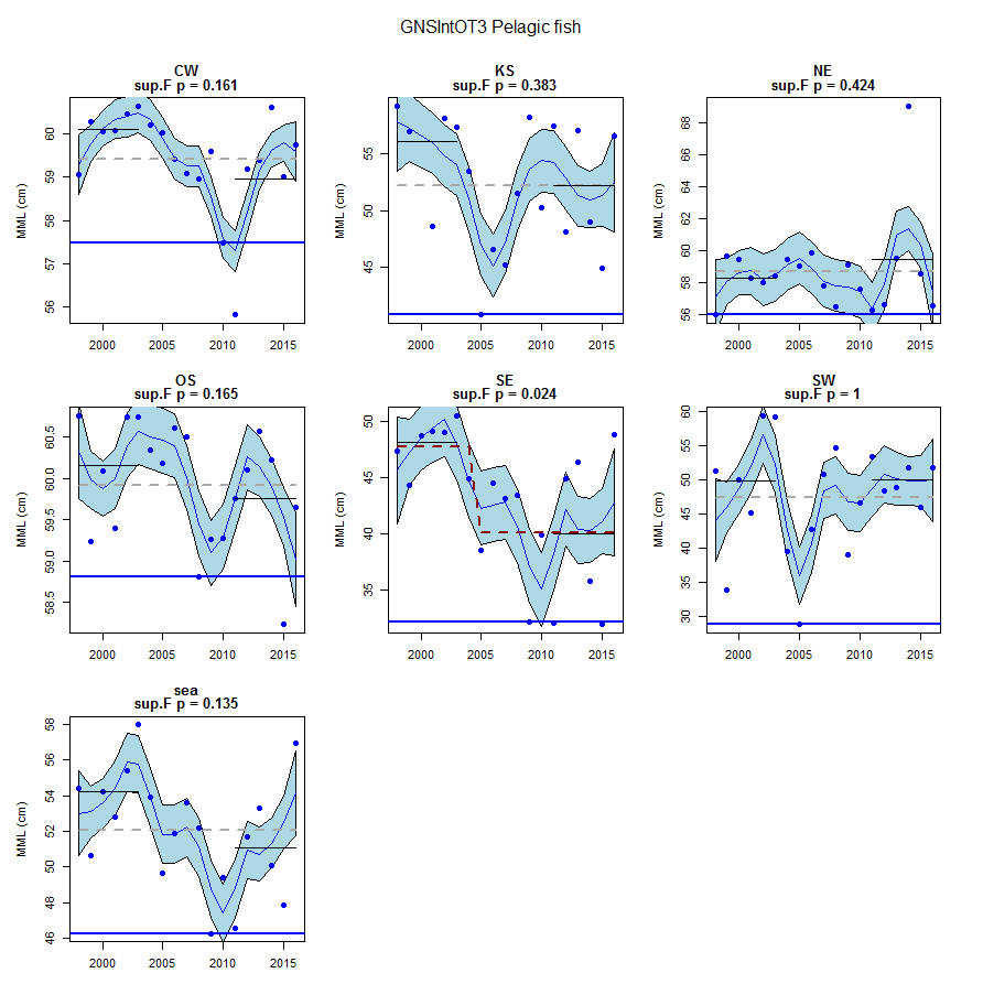
Figure 9. GNSIntOT3 pelagic fish community.
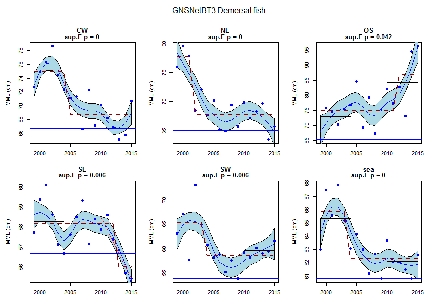
Figure 10. GNSNetBT3 demersal fish community.
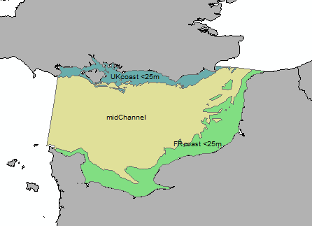
Figure 11. English Channel sub-divisions used as a basis for GNSEngBT3 analyses.
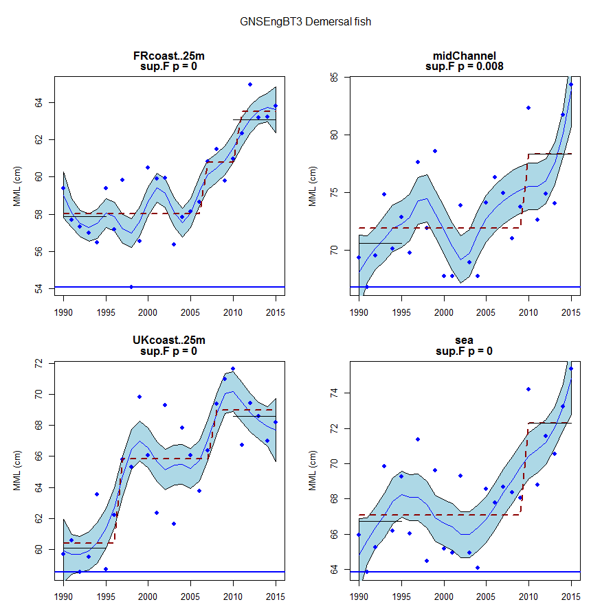
Figure 12. GNSEngBT3 demersal fish community in the Channel.
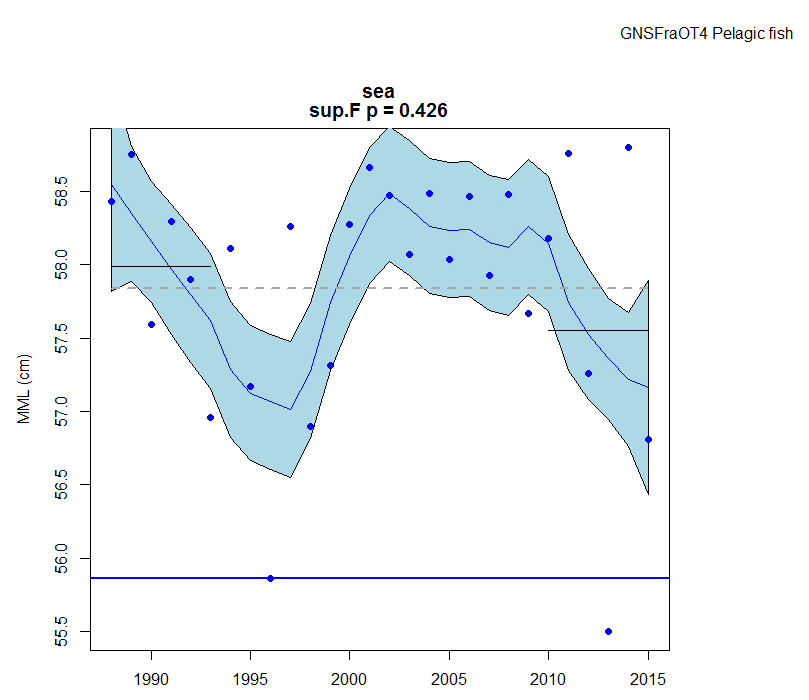
Figure 13. GNSFraOT4 pelagic fish community in the Channel.
Celtic Seas
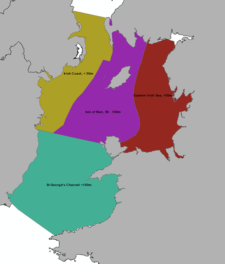
Figure 14. Irish Sea subdivisions used as a basis for CSEngBT3, CSNIrOT1 and CSNIrOT4 analyses. Note that the deep area of Beaufort’s Dyke is shown within the Irish Coast stratum, but this assessment does not represent Beaufort’s Dyke.
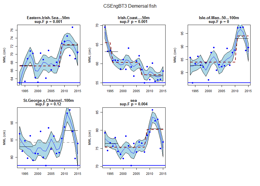
Figure 15. CSEngBT3 demersal fish community.
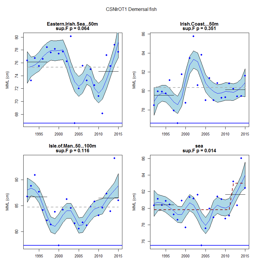
Figure 16. CSNIrOT1 demersal fish community.
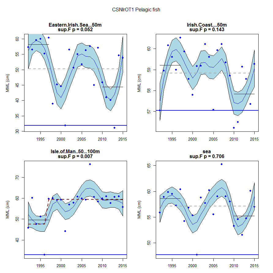
Figure 17. CSNIrOT1 pelagic fish community.
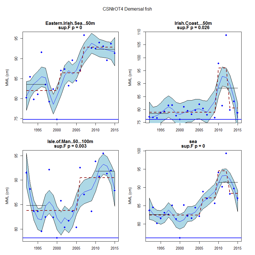
Figure 18. CSNIrOT4 demersal fish community.
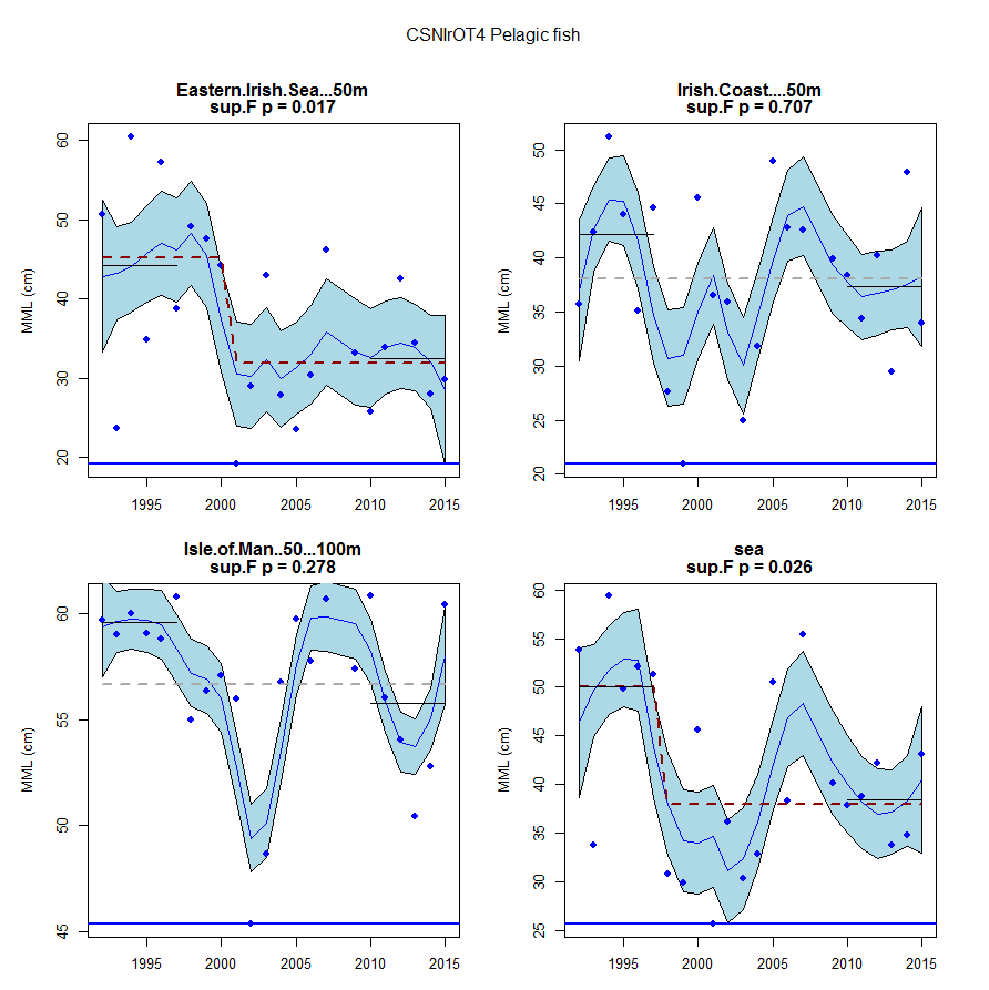
Figure 19. CSNIrOT4 pelagic fish community.
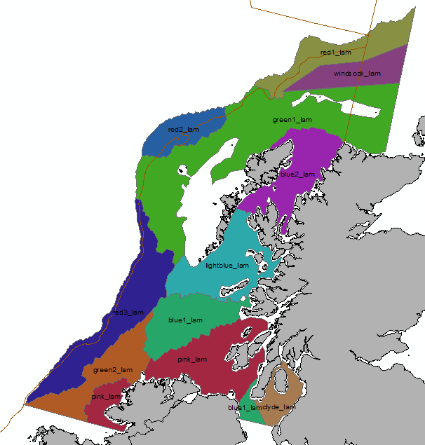
Figure 20. West of Scotland sub-divisions used as a basis for CSScoOT1 analyses.
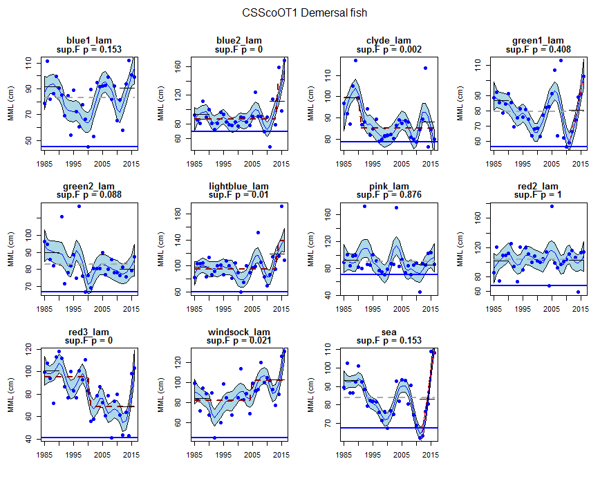
Figure 21. CSScoOT1 demersal fish community.
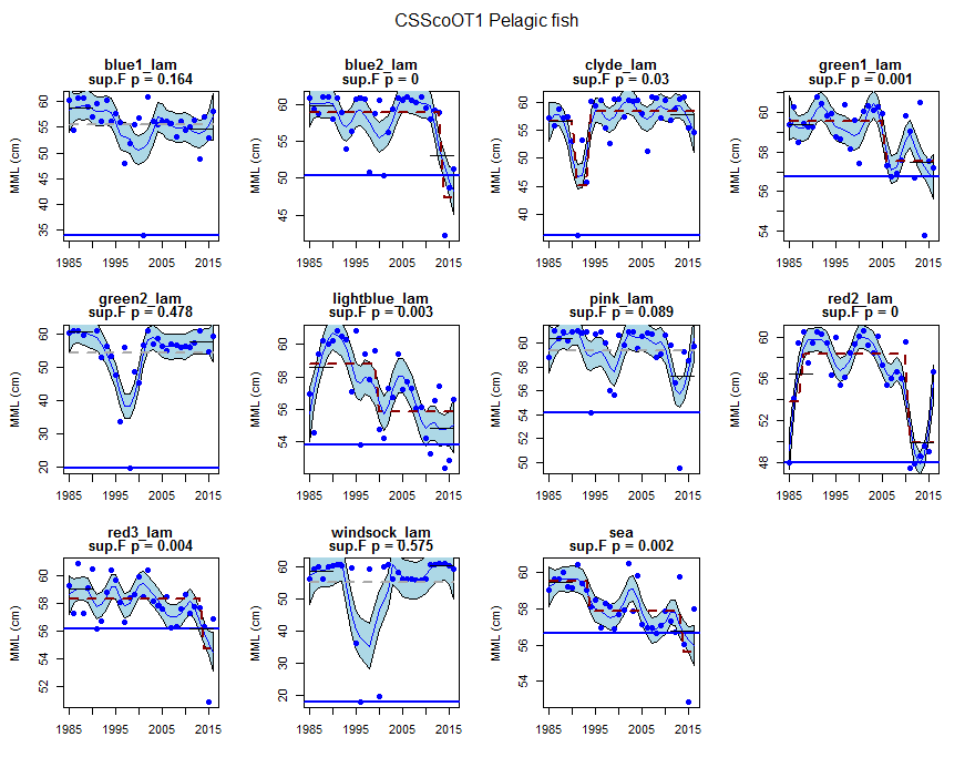
Figure 22. CSScoOT1 pelagic fish community.
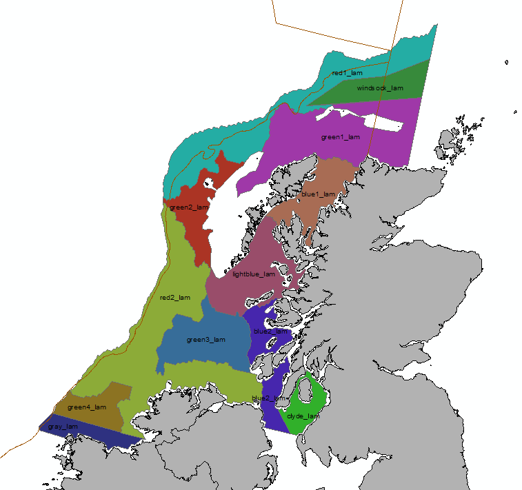
Figure 23. West of Scotland sub-divisions used as a basis for CSScoOT4 analyses.
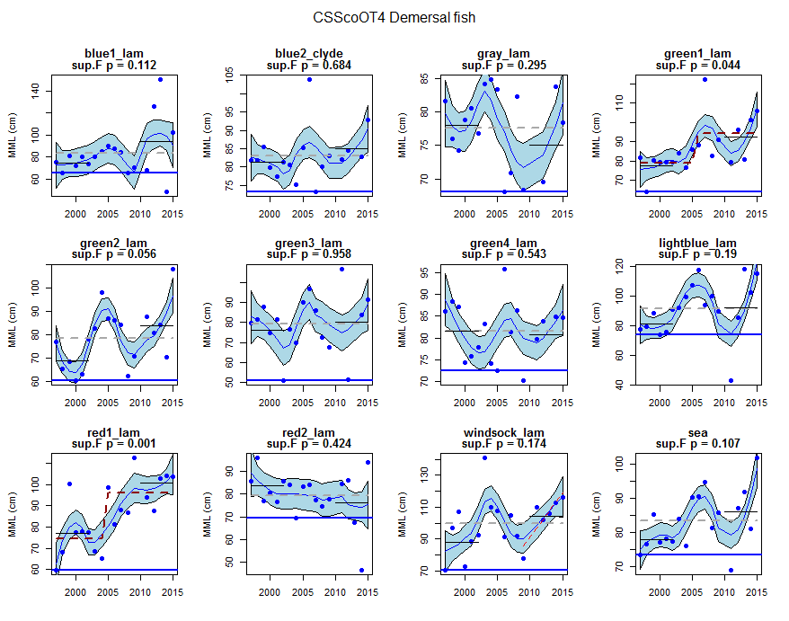
Figure 24. CSScoOT4 demersal fish community.
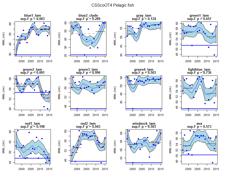
Figure 25. CSScoOT4 pelagic fish community.
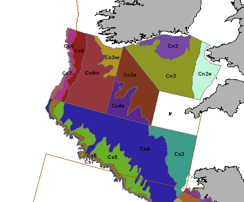
Figure 26. Celtic Sea sub-divisions used as a basis for CSFraOT4 analyses.
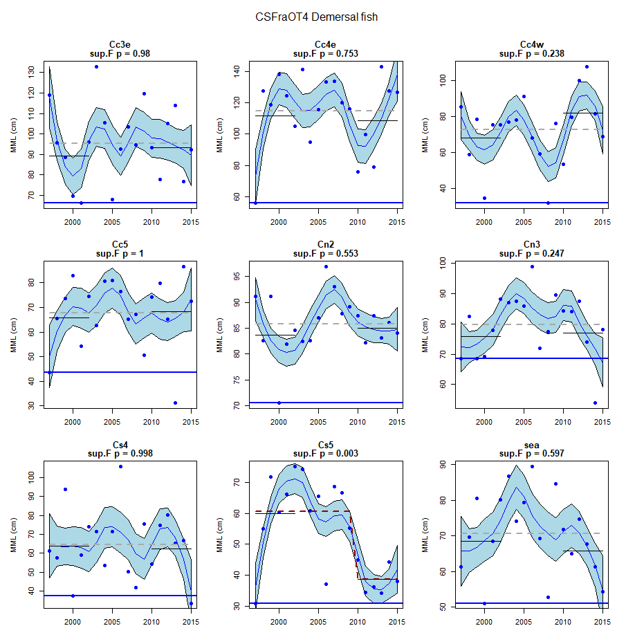
Figure 27. CSFraOT4 demersal fish community.
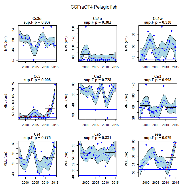
Figure 28. CSFraOT4 pelagic fish community.
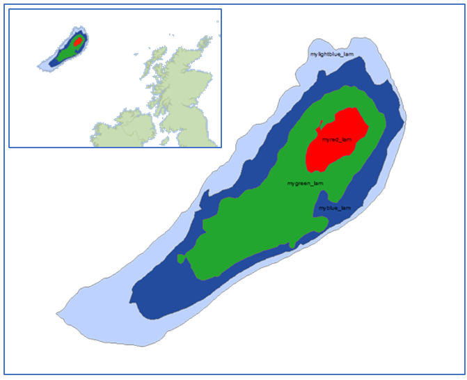
Figure 29. Rockall Bank sub-divisions used as a basis for WAScoOT3 analyses.
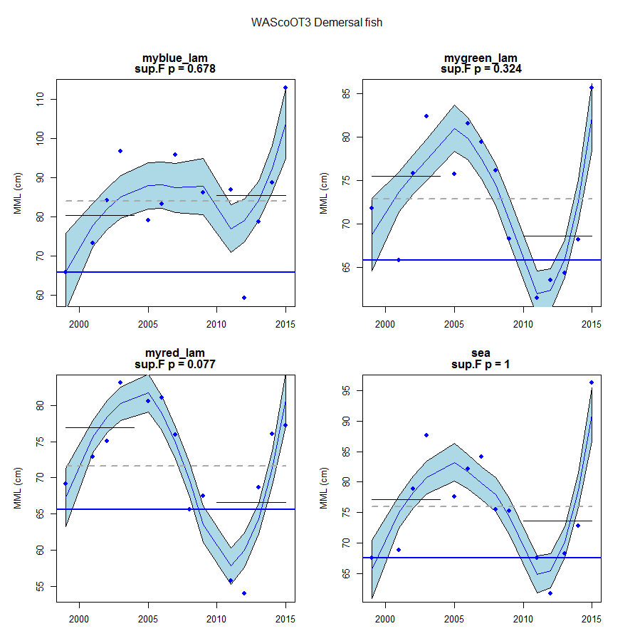
Figure 30. WAScoOT3 demersal fish community.
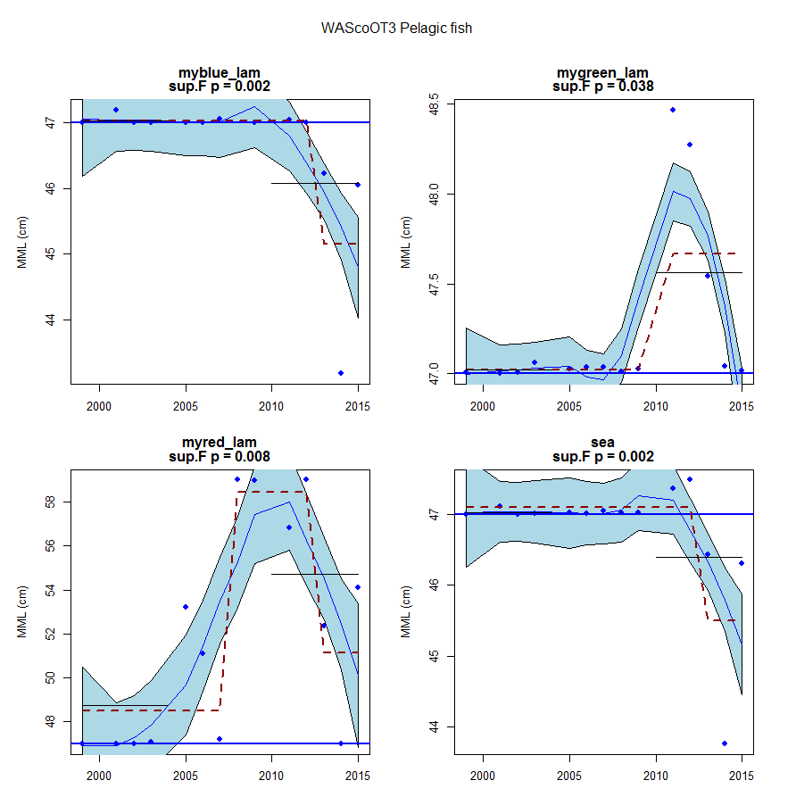
Figure 31. WAScoOT3 pelagic fish community.
Conclusions
In the Greater North Sea there was an overall decline in mean maximum length for both demersal and pelagic fish communities, which implies that the proportion of vulnerable species (large or slow-growing species with late maturity) is declining. However, in the English Channel demersal fish communities appear to be recovering.
In the Celtic Seas, there is no overall trend in mean maximum length, which has varied greatly over time, between surveys, and between sub-divisions, especially for demersal fish. But in some areas of the Celtic seas, there are increases in mean maximum length, which may indicate the start of the recovery in local communities as a result of a recent reduction in fishing mortality.
Further information
The results from this assessment provide further context to the other fish community indicator assessments of demersal communities. At a regional scale, all indicators provide similar conclusions, but at a finer scale responses diverge. While fishing is the most likely driver of these patterns in mean maximum length, it is unclear whether observed declines are caused by exploitation only or whether there are possible alternative causes. For example, global warming may have caused an influx of species with smaller maximum lengths.
Knowledge gaps
- The main causes of the observed spatial and temporal patterns in the mean maximum length indicator are not yet known.
- Reference levels representing a sustainably exploited state and that would allow a formal assessment are not yet available.
- The use of beam trawl data for demersal fish community assessment and otter trawl data for pelagic fish community assessment is new and requires further investigation to improve the assessment.
Further information
It is currently unclear whether the observed decline in mean maximum length is caused by fisheries exploitation only or whether there are possible alternatives. For example, the warming of the Greater North Sea due to climate change may have caused an inflow of Lusitanian (warm-water southern) species, especially in the southern part of the Greater North Sea. These Lusitanian species tend to be smaller-bodied than Boreal (cold-water northern) species. Additional analyses are required to separate these two possible causes. Further research is required to disentangle many of the factors that may have caused or contributed to the observed spatial and temporal patterns.
Further work is required to evaluate baselines and assessment values. However, the time series do not extend to a period where it can be assumed that species composition was not impacted, or possibly even representative of sustainable exploitation. During the early 1980s, key commercially fished pelagic species (herring (Clupea harengus), mackerel (Scomber scombrus), sprat (Sprattus sprattus)) were recovering from stock depletion, such that the species composition of the community in this period was already likely to be heavily impacted. Even before this time, other vulnerable pelagic and demersal species, such as Atlantic bluefin tuna (Thunnus thynnus) and common skate (Dipturus batis-complex) were extirpated from the Greater North Sea. As a result, any historical baseline for the fish and elasmobranch community will represent an impacted state.
References
Adams, PB (1980) ‘Life history patterns in marine fishes and their consequences for management’ Fishery Bulletin, 68:1-12 (viewed on 22 November 2018)
Brander K (1981) ‘Disappearance of common skate Raia batis from the Irish Sea’ Nature, 68:48-49 (viewed on 22 November 2018)
European Commission (2008a) ‘Directive 2008/56/EC of the European Parliament and of the Council of 17 June 2008 establishing a framework for community action in the field of marine environmental policy (Marine Strategy Framework Directive)’ Official Journal of the European Union L 164, 25.6.2008, pages 19-40 (viewed 21 September 2018)
European Commission (2008b) ‘Commission Regulation (EC) No 665/2008 of 14 July 2008 laying down detailed rules for the application of Council Regulation (EC) No 199/2008 concerning the establishment of a Community framework for the collection, management and use of data in the fisheries sector and support for scientific advice regarding the Common Fisheries Policy’ Official Journal of the European Union L 186, 15.7.2008, pages 3–5 (viewed on 22 November 2018).
Fraser HM, Greenstreet SPR, Piet GJ (2007) ‘Taking account of catchability in groundfish survey trawls: implications for estimating demersal fish biomass’ ICES Journal of Marine Science, 64:1800–1819 (viewed on 22 November 2018)
Greenstreet SPR, Hall SJ (1996) ‘Fishing and ground-fish assemblage structure in the north-western North Sea: an analysis of long-term and spatial trends’ Journal of Animal Ecology, 68:577-598 (viewed on 22 November 2018)
Greenstreet SPR, Fraser HM, Rogers SI, Trenkel VM, Simpson SD, Pinnegar JK (2012) ‘Redundancy in metrics describing the composition, structure, and functioning of the North Sea demersal fish community’ ICES Journal of Marine Science, 69:8-22 (viewed on 22 November 2018)
Greenstreet SPR, Moriarty M (2017) ‘OSPAR Interim Assessment 2107 Fish Indicator Data Manual (Relating to Version 2 of the Groundfish Survey Monitoring and Assessment Data Product)’ Scottish Marine and Freshwater Science Volume 8 Number 17, 83 pages (viewed on 22 November 2018)
Harvey PH (1996) ‘Phylogenies for ecologists’ Journal of Animal Ecology 54:144-152.
HM Government (2012) ‘Marine Strategy Part One: UK Initial Assessment and Good Environmental Status’ (viewed on 5 July 2018)
HM Government (2015) ‘Marine Strategy Part Three: UK Programme of Measures’ December 2015 (viewed on 5 July 2018)
ICES (2012) Report of the Working Group on The Ecosystem Effects of Fishing Activities (WGECO)’ ICES CM 2012/ACOM:26, Copenhagen, Denmark, 192 pages (viewed on 22 November 2018)
ICES (2014) ‘Interim Report of the Working Group on Multispecies Assessment Methods (WGSAM)’ CM 2014/SSGSUE:11, London, UK (viewed on 22 November 2018)
ICES (2016) ‘Report of the Working Group on the Ecosystem Effects of Fishing Activities (WGECO)’ ICES CM 2016/ACOM:25, Copenhagen, Denmark, 110 pages (viewed on 22 November 2018)
Jennings S, Kaiser MJ (1998) ‘The effects of fishing on marine ecosystems’ Advances in Marine Biology, 68:201-352 (viewed on 22 November 2018)
Jennings S, Reynolds JD, Mills SC (1998) ‘Life history correlates of responses to fisheries exploitation’ Proceedings of the Royal Society B, Biological Sciences, 265: 333-339 (viewed on 22 November 2018)
Jennings S, Greenstreet SPR, Reynolds JD (2001) ‘Structural change in an exploited fish community: a consequence of differential fishing effects on species with contrasting life histories’ Journal of Animal Ecology, 68: 617-627 (viewed on 22 November 2018)
Kirkwood GP, Beddington JR, Rossouw JA (1994) ‘Harvesting species of different lifespans’ Large-Scale Ecology and Conservation Biology (editors PJ Edwards, RM May, NR Webb) pages 199 227. Blackwell Science Limited, Oxford.
Myers RA, Hutchings JA, Barrowman NJ (1996) ‘Hypothesis for the decline of cod in the North Atlantic’ Marine Ecology Progress Series, 68: 293-308 (viewed on 22 November 2018)
OSPAR Commission (2017) ‘Intermediate Assessment 2017’ (viewed on 21 September 2018)
Probst WN, Stelzenmüller V (2015) ‘A benchmarking and assessment framework to operationalise ecological indicators based on time series analysis’ Ecological Indicators 55: 94-106 (viewed on 22 November 2018)
Roff DA (1984) ‘The evolution of life history parameters in teleosts’ Canadian Journal of Fisheries and Aquatic Science, 68:989-1000 (viewed on 22 November 2018)
Shephard S, Fung T, Houle JE, Farnsworth KD, Reid DG, Rossberg AG (2012) ‘Size-selective fishing drives species composition in the Celtic Sea’ ICES Journal of Marine Science, 69: 223–234 (viewed on 22 November 2018)
Sutherland WJ, Reynolds JD (1998) ‘Sustainable and unsustainable exploitation’ Chapter 5 in Conservation Science and Action (editor: WJ Sutherland), pages 90 - 115. Blackwell Science Limited, Oxford (viewed on 22 November 2018)
Vince MR (1991) ‘Stock identity in spurdog (Squalus acanthias L.) around the British Isles’ Fisheries Research, 68: 341-354 (viewed on 2 November 2018)
von Bertalanffy L (1957) ‘Quantitative laws in metabolism and growth’ Quarterly Review of Biology, 32: 217-221 (viewed on 22 November 2018)
Walker PA, Heessen HJL (1996) ‘Long-term changes in ray populations in the North Sea’ ICES Journal of Marine Science, 68: 1085-1093 (viewed on 22 November 2018)
Walker ND, Maxwell DL, Le Quesne WJF, Jennings S (2017) ‘Estimating efficiency of the survey and commercial trawl gears from comparisons of catch-ratios’ ICES Journal of Marine Science, 74(5): 1448-1457 (viewed on 22 November 2018)
Assessment metadata
| Assessment Type | UK MSFD Indicator Assessment |
|---|---|
D1 Fish Biodiversity Species composition in fish communities (mean maximum length) | |
| Point of contact email | marinestrategy@defra.gov.uk |
| Title | Fisheries survey data from Research Vessels |
| Resource abstract | The Groundfish Survey Monitoring and Assessment Data Product data derived by Marine Scotland from data collected during Research Vessel surveys, co-ordinated by International Council for the Exploration of the Seas (ICES), from January 1983 to June 2017 for surveys of the northeast Atlantic shelf and marginal seas. |
| Linkage | Acquisition during Research Vessel cruises Sampling device: otter and beam trawls Manual for the data product used in the assessment Greenstreet, S.P.R and Moriarty, M. (2017) Manual for Version 3 of the Groundfish Survey Monitoring and Assessment Data Product. Scottish Marine and Freshwater Science Vol 8 No 18, 77pp. DOI: 10.7489/1986-1 Moriarty, M., Greenstreet, S.P.R. and Rasmussen, J. (2017) Derivation of Groundfish Survey Monitoring and Assessment Data Product for the Northeast Atlantic Area. Scottish Marine and Freshwater Science Vol 8 no 16, 240pp. DOI: 10.7489/1984-1 |
| Conditions applying to access and use | © Crown copyright, licenced under the Open Government Licence (OGL). |
| Assessment Lineage | The Groundfish Survey Monitoring and Assessment (GSMA) data product is a single set of fully standardised and quality assured data products for all the surveys operating in the Northeast Atlantic. |
| Indicator assessment results | Survey data were used to determine abundance trends in sensitive species, the relative biomass of large fish, the species composition where species are ranked by the maximum length recorded in the data product and the geometric mean length as an indicator of size structure |
| Dataset metadata | |
| Dataset DOI |
Moriarty, M., Greenstreet, S. 2017. Greater North Sea Dutch Beam Trawl Quarter 3 Groundfish Survey Monitoring and Assessment Data Products. DOI: 10.7489/1967-1 Moriarty, M., Greenstreet, S. 2017. Greater North Sea International Otter Trawl Quarter 1 Groundfish Survey Monitoring and Assessment Data Products. DOI: 10.7489/1922-1 Moriarty, M., Greenstreet, S. 2017. Celtic Sea Irish Quarter 4 Otter Trawl Groundfish Survey Monitoring and Assessment Data Products. doi: 10.7489/1925-1 Moriarty, M., Greenstreet, S. 2017. Greater North Sea International Otter Trawl Quarter 3 Groundfish Survey Monitoring and Assessment Data Products. doi: 10.7489/1923-1 Moriarty, M., Greenstreet, S. 2017. Celtic Sea Scottish Otter Trawl Quarter 4 Groundfish Survey Monitoring and Assessment Data Products. doi: 10.7489/1924-1 Moriarty, M., Greenstreet, S. 2017. Celtic Sea Scottish Quarter 1 Otter Trawl Groundfish Survey Monitoring and Assessment Data Products. doi: 10.7489/1957-1 Moriarty, M., Greenstreet, S. 2017. Celtic Sea /Bay of Biscay French Quarter 4 Otter Trawl Groundfish Survey Monitoring and Assessment Data Products. doi: 10.7489/1958-1 Moriarty, M., Greenstreet, S. 2017. Greater North Sea French Otter Trawl Quarter 4 Groundfish Survey Monitoring and Assessment Data Products. doi: 10.7489/1959-1 Moriarty, M., Greenstreet, S. 2017. Celtic Sea Northern Ireland Otter Trawl Quarter 1 Groundfish Survey Monitoring and Assessment Data Products. doi: 10.7489/1961-1 Moriarty, M., Greenstreet, S. 2017. Celtic Sea Northern Ireland Otter Trawl Quarter 4 Groundfish Survey Monitoring and Assessment Data Products. doi: 10.7489/10.7489/1962-1 Moriarty, M., Greenstreet, S. 2017. Celtic Sea English Quarter 3 Beam Trawl Groundfish Survey Monitoring and Assessment Data Products. doi: 10.7489/1964-1 Moriarty, M., Greenstreet, S. 2017. Greater North Sea German Beam Trawl Quarter 3 Groundfish Survey Monitoring and Assessment Data Products. doi: 10.7489/1965-1 Moriarty, M., Greenstreet, S. 2017. Greater North Sea English Beam Trawl Quarter 3 Groundfish Survey Monitoring and Assessment Data Products. doi: 10.7489/1966-1 Moriarty, M., Greenstreet, S. 2017. Bay of Biscay Iberian Coast Portugal Otter Trawl Quarter 4 Groundfish Survey Monitoring and Assessment Data Products. doi: 10.7489/1963-1 Moriarty, M., Greenstreet, S. 2017. Wider Atlantic Scottish Otter Trawl Quarter 3 Groundfish Survey Monitoring and Assessment Data Products. doi: 10.7489/1960-1 |
The Metadata are “data about the content, quality, condition, and other characteristics of data” (FGDC Content Standard for Digital Geospatial Metadata Workbook, Ver 2.0, May 1, 2000).
Metadata definitions
Assessment Lineage - description of data sets and method used to obtain the results of the assessment
Dataset – The datasets included in the assessment should be accessible, and reflect the exact copies or versions of the data used in the assessment. This means that if extracts from existing data were modified, filtered, or otherwise altered, then the modified data should be separately accessible, and described by metadata (acknowledging the originators of the raw data).
Dataset metadata – information on the data sources and characteristics of data sets used in the assessment (MEDIN and INSPIRE compliance).
Digital Object Identifier (DOI) – a persistent identifier to provide a link to a dataset (or other resource) on digital networks. Please note that persistent identifiers can be created/minted, even if a dataset is not directly available online.
Indicator assessment metadata – data and information about the content, quality, condition, and other characteristics of an indicator assessment.
MEDIN discovery metadata - a list of standardized information that accompanies a marine dataset and allows other people to find out what the dataset contains, where it was collected and how they can get hold of it.
Recommended reference for this indicator assessment
Lynam, C.P.1, Moriarty, M.2, & Greenstreet, S.P.R.2 2018. Species Composition in Fish Communities (Mean Maximum Length) *. UK Marine Online Assessment Tool, available at: /biodiversity-food-webs-and-marine-protected-areas/fish/community/
* Adapted from OSPAR Intermediate Assessment 2017 on Pilot Assessment of Mean Maximum Length of Fish
1Centre for Environment, Fisheries and Aquaculture Science
2Marine Scotland
