
Condition of intertidal sediments in coastal waters determined using Water Environment Regulations opportunistic macroalgae blooming assessment methods.
The targets determining the extent of intertidal areas with acceptable opportunistic macroalgae growth may not have been achieved in the Celtic Sea and Greater North Sea UK Marine Strategy (UKMS) sub-regions. Achievement of the target varies between UK biogeographic Regional Seas. Data coverage is limited and there is low confidence in the assessment results.
Background
UK Target on intertidal opportunistic macroalgae quality
This indicator is used to assess progress against the Water Environment Regulations (WER) ecological status boundaries and areas of unacceptable impact, which are components of the sediment habitats targets, set in the UK Marine Strategy Part One.
Key pressures and impacts
The opportunistic macroalgae tool is designed to detect the symptoms of eutrophication due to increase nutrient concentrations, but to a lesser extent may also reflect changes in levels of suspended particles in response to physical disturbances including hydromorphological changes (i.e. those that alter a water body’s physical structure and flow characteristics). Opportunistic macroalgal blooms resulting from elevated nutrient concentrations may adversely impact the benthic communities of the underlying sediment, alter the feeding behaviour of wading birds and smothering of seagrass beds.
Risk assessment information used in the UKMS assessments was derived by the UK WER monitoring authorities to support the Cycle One River Basin Management Plan classifications by identifying pressures considered likely to cause water bodies to fail to achieve their WER environmental objectives. These identified 26 of the 467 coastal water bodies as ‘At risk’ or ‘Probably at risk’ of failing to meet their WER objectives due to elevated nutrient/diffuse source pressures.
Measures taken to address the impacts
Measures to limit the effects of eutrophication and protect benthic habitats are set out in the UK Marine Strategy Part Three. These include those related to the Habitats Regulations, WER River Basin Management Plans, Urban Wastewater Treatment Regulations, Nitrate Pollution Prevention Regulations, the Convention for the Protection of the Marine Environment of the North-East Atlantic (OSPAR) measures on species and habitats, Marine Spatial Planning, land management schemes, catchment sensitive farming and European Marine Site management schemes.
Monitoring, assessment and regional cooperation
Areas that have been assessed
Progress against the UK target was assessed for the Celtic Sea UK Marine Strategy sub-region and Greater North Sea UK Marine Strategy sub-region and their constituent UK Charting Progress 2 (CP2) (UKMMAS, 2010) Regional Seas.
Monitoring and assessment methods
Routine monitoring of intertidal opportunistic macroalgae is undertaken using methods developed under WER. The intertidal opportunistic macroalgae tool is a multi-metric index composed of five metrics: percent cover of the Available Intertidal Habitat (AIH), total extent of area covered by algal mats or affected area as a percentage of the AIH, average biomass of the AIH, average biomass of the Affected Area (AA) and the presence of entrained algae. These measurements are combined with equal weightings to derive an Ecological Quality Ratio (EQR).
Assessment thresholds
The indicator quality threshold is defined as the boundary for WER Good Ecological Status (EQR ≥0.60) or Good Ecological Potential (GEP) for Heavily Modified Water Bodies (HMWBs). The UK Marine Strategy assessment target is met where the assessed surface area achieving the quality threshold meets the extent threshold of 95%.
Regional cooperation
The indicator has not been used for the OSPAR Quality Status Report 2023 but may be used for future regional analysis. The boundary of WER Good Ecological Status has been set through Intercalibration with Member States of the North-East Atlantic Geographical Intercalibration Group (NEAGIG).
Further information
The Water Environment Regulations opportunistic macroalgae tool is a multi-metric indicator derived from the following measurements of the opportunistic macroalgal cover within the measured Available Intertidal Habitat (AIH) of a water body:
% Cover of Available Intertidal Habitat (AIH): This is the percentage cover estimated from the quadrats measured over all of the macroalgal patches of the AIH.
Total extent of algal bloom (Affected Area-AA)*: This is a measure of the total area affected by the algal bloom and is measured in hectares.
AA/AIH (%)*: We also calculate the affected area as a percentage of the AIH but only use the worse of these two (asterisked) measures. This helps to adjust the impact to the size of the water body.
Biomass of the Affected Area (AA): Opportunistic macroalgae are cut and peeled from the surface of each quadrat, washed and weighed wet.
Biomass over the Available Intertidal Habitat (AIH): This is the estimate of the average biomass of algae over the whole of the available intertidal habitat.
Proportion of entrained algae: This is an estimate of the percentage of quadrats where algae grow down into the underlying sediment.
The effects of weed cover are greatest on sites which are consistently covered by deep blooms; sites affected only intermittently have greater opportunity to recover, with flushing of the sediment by seawater. In pristine waters few or no macroalgal blooms would be expected, and the cover of the indicator species would be less than 5% of the AIH. As nutrient pressure increases there would be significant cover of macroalgae and an increase in biomass; algal entrainment may occur in > 1% of quadrats. At this level there is likely to be some impact on the sediment and animals in the mud below algal mats.
Values of the above metrics were determined to represent undisturbed waters (reference conditions). The observed results are then compared with the reference condition values and combined to calculate the Ecological Quality Ratio (EQR) which operates between zero and one. EQR values close to one indicates the extent of macroalgae coverage within the available intertidal habitats is close to its natural state; those near zero indicate a high level of pollution or disturbance. The EQR is used to categorise the water body into one of the five Ecological Quality Status classes as required by the WER:
High status: ≥ 0.8
Good status: 0.6 ≤ 0.8
Moderate status: 0.4 ≤ 0.6
Poor status: 0.2 ≤ 0.4
Bad status: <0.2
Further details on the WER intertidal opportunistic macroalgae tool are available at the WER UK Technical Advisory Group (UKTAG) website:
Assessment method
Baseline setting
The WER opportunistic macroalgae indicator reference conditions have been used for the UK Marine Strategy baseline. Reference conditions are based on zero levels of cover, biomass and entrainment of opportunistic macroalgae within the available intertidal area. This complies with the approach to setting baselines for UK Marine Strategy as outlined by OSPARs Intersessional Correspondence Group on Biodiversity Assessment and Monitoring (ICG COBAM) (2012) as “a state in which the anthropogenic influences on species and habitats are considered to be negligible”.
Quality target
The target of Good Ecological Status or Good Ecological Potential (where mitigation measures against the modification features are considered sufficient for Heavily Modified Water bodies (HMWBs)) as defined for the WER is being applied as the indicator quality threshold for the UK Marine Strategy assessments. The extent target is met where ≥95% of the surface area of the assessed Available Intertidal Habitat (AIH) within a UK Regional Sea meet the quality threshold for the opportunistic macroalgae indicator. Intertidal Mudflats are priority habitats within the UK Biodiversity Action Plan (BAP). Whilst opportunistic macroalgae blooming can also occur on intertidal sand habitats, they are typically associated with finer sediments associated with mudflats. The 95% extent target conforms to that relating to the assessed surface area at an acceptable condition recommended by the Water Framework Directive UK Technical Advisory Group (WFD-UKTAG) (2007) for High Ecological Status and the Habitats Regulations target for Favourable Condition.
This may be reviewed and revised in future assessment cycles.
Aggregation approach
The approach to aggregating the WER water body classifications to UK Regional Sea assessments is shown below. Please note: UK Marine Strategy assessments are based on the data and processes used for the WER water body classifications within the 2021 Cycle Three River Basin Management Plan (RBMP) assessments and exclude changes to the classifications as a result of subsequent investigations.
-
Opportunistic macroalgae WER classification results for coastal water bodies from the 2021 Cycle Three RBMPs were collated at the water body level from the UK WER monitoring authorities. The percentage of AIH at each WER ecological status class was calculated within each UK Regional Sea. The assessments use data derived WER classification results for use in the WER Cycle Three RBMP and exclude those rolled forwards from previous classifications.
-
Areas of AIH categorised as ‘Bad’, ‘Poor’ or ‘Moderate’ ecological status under WER were categorised as being below the indicator quality target, with those at ‘Good’ or ‘High’ ecological status categorised as being above the indicator quality target.
-
The final UK Regional Sea assessment is calculated using the total percentage of AIH within all classified water bodies which meets the indicator quality target. The overall indicator target is achieved when the extent of classified AIH meeting the quality target is ≥95% of all classified AIH within a UK Regional Sea.
Confidence assessment
The approach to determining confidence in the UK Regional Sea assessments is based on the extent to which the indicator and associated assessments fulfil certain criteria which impact the extent to which the assessment represents the available habitat relevant to the indicator, the extent to which the indicator can identify the overall effect of the relevant pressures and the confidence in the assessment result being above/below the indicator target. The confidence assessment method was developed for the 2018 Marine Strategy assessments. Confidence thresholds were arbitrarily set based on an equal division of the range of values for each criterion. Details of the criteria are provided in Table 1.
Table 1: Confidence assessment criteria for the UK Regional Sea WER intertidal opportunistic macroalgae indicator assessments.
|
UK Regional Sea confidence assessment criteria |
Low |
Medium |
High |
|
Spatial coverage of classification data
This criterion indicates the extent to which WER water bodies within a UK Regional Sea are classified by the indicator. High proportion of water bodies classified within a UK Regional Sea corresponds to high confidence in the UK Marine Strategy assessment. |
<33.3% of WER water bodies assessed |
33.3% - 66.6% of water bodies assessed |
>66.6% of water bodies assessed |
|
Spatial coverage of pressures
This criterion provides a measure of the extent to which the classified WER water bodies correspond to the presence of relevant pressures (as determined through the WER risk assessments), indicating the potential of the WER classifications to detect the associated impacts of such pressures. High coverage of the areas exposed to pressure (i.e. those considered at risk of failing to achieve GES under WER) by the WER water body classifications corresponds to high confidence within the UK Regional Sea scale UK Marine Strategy assessment. |
<33.3% of At Risk/Probably At Risk Water Bodies (WBs) assessed |
33.3% - 66.6% of At Risk/Probably At Risk WBs assessed |
>66.6% of At Risk/Probably At Risk WBs assessed |
|
Indicator level agreement (Cohen's Kappa) between assessment results and pressure from Risk Assessments
Cohen’s Kappa agreement provides an indication of the extent to which the indicator WER classifications correspond to the risk assessments at the water body level. Agreement between water bodies categorised as ‘At Risk’/’Probably At Risk’ and those at less than Good Ecological Status is calculated using all water body data. High confidence in the UK Marine Strategy assessments corresponds to high agreement between the indicator classifications and risk assessment results. Low correspondence may be indicative of either low sensitivity of the indicator to the pressure or indicative of a low correspondence between the risk assessment results and the true extent of the pressure (further investigation recommended). |
<0.333 |
0.333 - 0.666 |
>0.666 |
|
Variability of assessment results
This criterion is a measure of the variability of the different WER water body classifications within a UK Regional Sea scale Marine Strategy assessment. Low variability in the WER classifications corresponds with high confidence in the assessment. |
<66.6% of assessed water bodies within same WER status |
66.6% - 83.3% of assessed water bodies at the same WER status |
>83.3% of assessed water bodies at the same WER status |
|
Proximity of observed extent to extent threshold
This criterion is a measure of the magnitude of the difference between the observed extent meeting the quality target and the extent threshold. Large differences between the observed extent meeting the quality target and the extent threshold corresponds to high confidence in the UK Regional Sea scale UK Marine Strategy assessment. |
BAP priority habitats: assessment within 1.66% of target |
BAP priority habitats: assessment within 1.66% - 3.33% of target |
BAP priority habitats: assessment >3.33% of target |
The overall confidence assessment is based on lowest extent to which the criteria are fulfilled (one-out-all-out).
Deviations by WER Monitoring Authorities
Opportunistic macroalgae data was collected for use in the WER Cycle Three RBMP classifications by the Department of Agriculture, Environment and Rural Affairs (DAERA) of Northern Ireland, the Environment Agency (EA) of England and Natural Resources Wales (NRW) only. All monitoring authorities applied the assessment methods as described within the UKTAG method statement.
Results
Results and assessment of progress
Latest findings
Status assessment
Assessments are based on aggregated coastal water body classifications derived for the 2021 UK River Basin Management Plans. The results of the aggregated intertidal opportunistic macroalgae indicator assessment for the UK Marine Strategy sub-regions and Regional Seas is presented in Table 2 and Figure 1.
Table 2: Proportion of total assessed Available Intertidal Habitat meeting the indicator quality threshold for each UK Regional Sea.
| UK MS sub-region | Extent meeting quality threshold (EQR ≥ 0.6) | Extent threshold met (≥ 95%) | Assessment summary | Regional Sea | Extent meeting quality threshold (EQR ≥0.6) | Extent threshold met (≥ 95%) | Confidence |
| Greater North Sea | 77.2 % | ❌ | Target not met for the sub-region (low confidence). | 1. Northern North Sea* | 0.1 % | ❌ | Low |
| 2. Southern North Sea | 100.0 % | ✅ | Low | ||||
| 3. Eastern English Channel | 100.0 % | ✅ | Low | ||||
| Celtic Sea | 86.0 % | ❌ | Target not met for the sub-region (low confidence). | 4. Western Channel and Celtic Seas | 100.0 % | ✅ | Low |
| 5. Irish Sea | 84.1 % | ❌ | Low | ||||
| 6. Minches and Western Scotland | No data | - | - | ||||
| 7. Scottish Continental Shelf | No data | - | - | ||||
| 8. Atlantic North-West Approaches, Rockall Trough and Faeroe/Shetland Channel | Suitable habitat absent | - | - | ||||
| 9. Shared waters between N Ireland and Rep of Ireland | No data | - | - |
The overall target may not have been met for both the Greater North Sea and Celtic Sea UK Marine Strategy sub-regions, with the quality target failing to be achieved for the total assessed areas of Available Intertidal Habitat (AIH) of the sub-regions. The assessment results of the Greater North Sea and Celtic Sea sub regions are driven by the failure to achieve the opportunistic macroalgae indicator quality targets above 95% of the assessed areas of Available Intertidal Habitat within WER coastal water body assessments of the Northern North Sea and Irish Sea Regional Seas respectively. All assessed areas of AIH within the Southern North Sea, Eastern English Channel and Western Channel and Celtic Seas achieved the opportunistic macroalgae indicator quality targets.
Four UK Regional Seas within the Celtic Sea sub-region have not been assessed due to either an absence of available intertidal habitat which is required by the indicator or an absence of existing WER classification data. The low risk of natural conditions required for opportunistic macroalgae blooming to occur limits the extent to which coastal water bodies are assessed with the indicator.
The confidence for WER intertidal opportunistic macroalgae indicator assessments has been categorised as low for all assessments, primarily due to low overall spatial coverage of the WER classification results and low proportion of water bodies categorised as being ‘At Risk’ or ‘Probably At Risk’ from nutrient pressures as identified within the WER Risk Assessments that were classified under WER. Overall agreement between intertidal opportunistic macroalgae assessment results and risk assessment results is medium to high, potentially indicating medium to high levels of correlation between the indicator and nutrient pressures, indicating a degree of reliability in the opportunistic macroalgae indicator in detecting the effects of nutrient pressures on intertidal habitats where assessments have been undertaken.
Findings from the 2012 and 2018 UK assessments
This indicator was not considered as part of the 2012 and 2018 UK Marine Strategy assessments.
Trend assessment
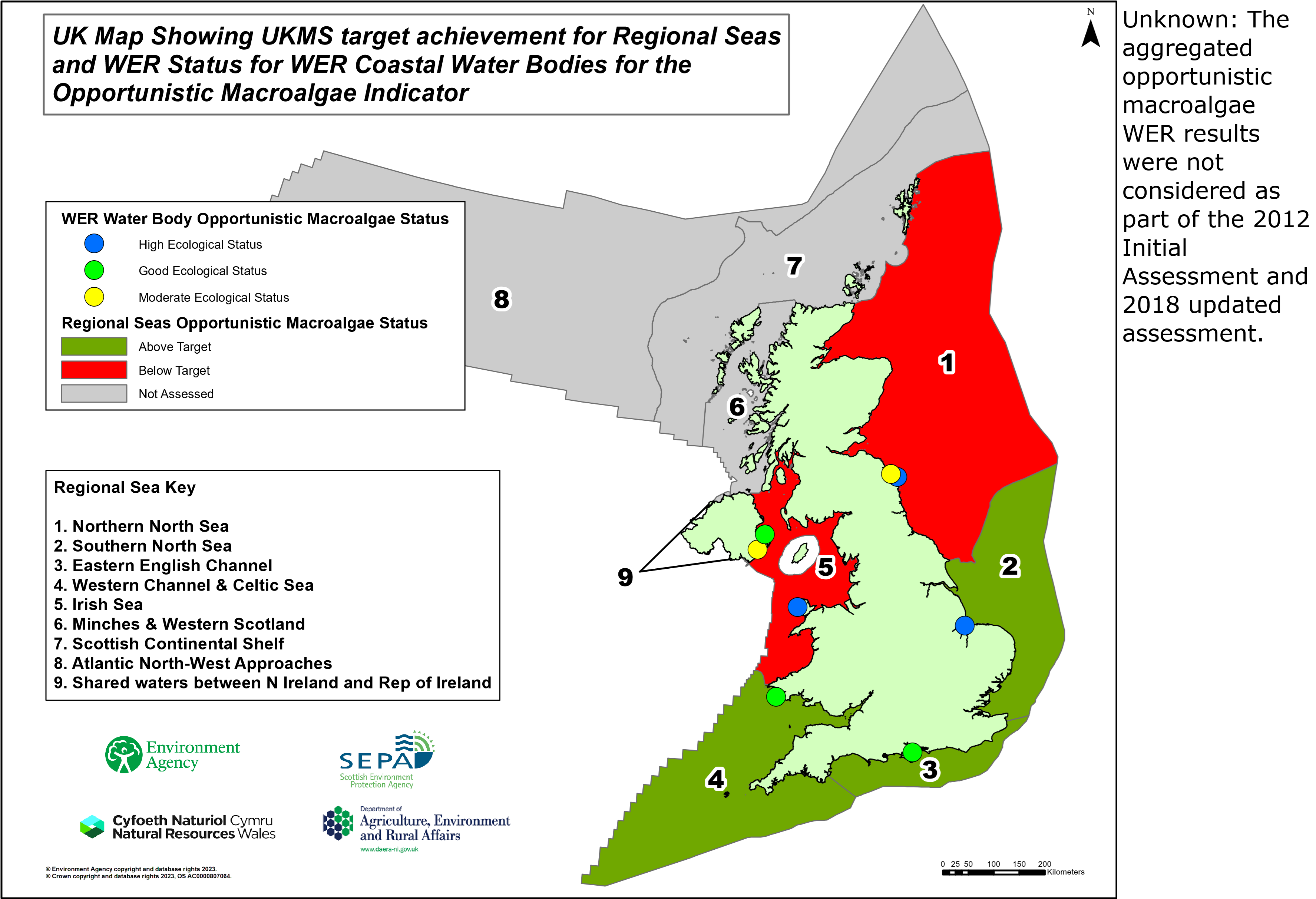
Figure 1: UK Regional Seas with corresponding assessment results with locations of coastal water bodies used for WER intertidal opportunistic macroalgae classifications with corresponding ecological status.
Further information
The assessment is based on aggregated results from the UK Water Environment Regulations classifications for the Cycle Three River Basin Management Plans. The method is based on multiple attributes of intertidal opportunistic macroalgae growth and considered responsive to nutrient enrichment pressures from inshore activities.
The UK WER risk assessments identified a total of 12.9% (13 of the 101 assessed) of coastal water bodies are ‘At Risk’ or ‘Probably At Risk’ of failing to meet their environmental objectives as a result of nutrient enrichment pressures.
The indicator determines the severity of opportunistic macroalgae growth on intertidal habitats by combining measures percent cover of the Available Intertidal Habitat (AIH), total extent of area covered by algal mats or affected area as a percentage of the AIH, average biomass of the AIH, average biomass of the Affected Area (AA) and the presence of entrained algae. The average of the five metrics are combined within an Ecological Quality Ratio (EQR). Metrics are calculated at the level of WER water body using data collected within a six-year period. The water body assessments indicate the extent to which opportunistic macroalgal growth exceeds that expected under reference conditions across the Available Intertidal Habitat of the water body. The extent deviation is related to the boundary between Moderate and Good Ecological Status to identify whether the water body has achieved the target of Good Ecological Status. The extent target is met where ≥95% (priority habitat threshold) of the assessed surface area meets the quality target of Good or High Ecological Status or Good Ecological Potential.
A summary of the data used for each UK Marine Strategy sub-region and Regional Sea WER opportunistic macroalgae indicator assessment is provided in Table 3. Individual WER water body information with associated Third Cycle River Basin Management Plan opportunistic macroalgae classification results is provided in Table 4.
Table 3: Summary of the data used for the UK Marine Strategy WER opportunistic macroalgae indicator Regional Sea assessments.
|
Regional Sea |
Regional Sea |
RS Total Area (sq km) |
RS Total WB area (sq km) |
Assessed WB Count |
Assessed WB Area (Km2) |
Assessed Area (% of total) |
Assessed HMWBs |
Assessed 'At Risk' WER WBs |
|
Greater North Sea |
1. Northern North Sea |
181,551.6 |
8,164.8 |
2 |
100.6 |
1.2 |
0 |
1 |
|
Greater North Sea |
2. Southern North Sea |
61,882.1 |
3,190.7 |
1 |
461.4 |
14.5 |
0 |
0 |
|
Greater North Sea |
3. Eastern English Channel |
21,970.8 |
1,903.5 |
1 |
259.6 |
13.6 |
1 |
0 |
|
Celtic Sea |
4. Western Channel and Celtic Seas |
93,959.8 |
5,086.4 |
1 |
35.4 |
0.7 |
0 |
0 |
|
Celtic Sea |
5. Irish Sea |
38,647.4 |
10,014.0 |
3 |
58.8 |
0.6 |
0 |
0 |
Table 4: Summary of WER water body pressure information and WER opportunistic macroalgae classification results aggregated to the UK Regional Sea Marine Strategy assessments.
|
Regional Sea |
Agency |
Water body name |
HMWB |
At Risk/Probably At Risk from Nutrient pressures |
Available Intertidal Habitat (Ha) |
Water body EQR |
WER status |
|
1. Northern North Sea |
EA |
Farne Islands to Newton Haven |
No |
No |
2.16 |
0.80 |
High |
|
1. Northern North Sea |
EA |
Holy Island & Budle Bay |
No |
Yes |
1637.25 |
0.58 |
Moderate |
|
2. Southern North Sea |
EA |
Wash Outer |
No |
No |
4202.06 |
0.80 |
High |
|
3. Eastern English Channel |
EA |
Solent |
Yes |
No |
1333.69 |
0.61 |
Good |
|
4. Western Channel & Celtic Seas |
NRW |
Milford Haven Outer |
No |
No |
305.32 |
0.65 |
Good |
|
5. Irish Sea |
DAERA |
Dundrum Bay Inner |
No |
No |
358.7 |
0.64 |
Moderate |
|
5. Irish Sea |
DAERA |
Strangford Lough North |
No |
No |
1481.8 |
0.71 |
Good |
|
5. Irish Sea |
NRW |
Holyhead Strait |
No |
No |
421.45 |
0.84 |
High |
Detailed assessment results for each UK Marine Strategy sub-region are presented for each of their component UK Regional Seas. The UK Marine Strategy sub-regions comprise of their component UK Regional Seas as follows:
Greater North Sea UK Marine Strategy sub-region:
1. Northern North Sea
2. Southern North Sea
3. Eastern English Channel
Celtic Sea UK Marine Strategy sub-region:
4. Western Channel & Celtic Seas
5. Irish Sea
6. Minches & Western Scotland
7. Scottish Continental Shelf
8. Atlantic North-West Approaches, Rockall Trough and Faeroe/Shetland Channel
9. Shared waters between N Ireland and Rep of Ireland
Northern North Sea
The overall risk of the Northern North Sea failing to meet the target for opportunistic macroalgae can be considered as high. The WER assessments within the Northern North Sea indicate that the assessed AIH is largely below the indicator quality target (Figure 2). The two water bodies within the Northern North Sea are at classified as WER Moderate and High Ecological Status, but with the quality threshold having been achieved for only 0.13% of the total assessed AIH from the water body assessments, therefore failing to meet the 95% extent target for the Regional Sea.

Figure 2: Outline of the Northern North Sea Regional Sea inshore indicating opportunistic macroalgae UK Marine Strategy assessment result and location and ecological status of the corresponding WER water bodies.
The corresponding WER risk assessments categorise one of the assessed water bodies (Holy Island & Budle Bay) as ‘At Risk’ or ‘Probably At Risk’ of failing to achieve the indicator quality target as a result of nutrients pressures, with the remaining water body being ‘Not At Risk’ or ‘’Probably Not At Risk’ of failing. The regional sea intersects with a total of 72 water bodies, although no further water bodies are considered 'At Risk' or ‘Probably At Risk’ of failing as a result of nutrients pressures.
The water body failing to meet the quality target (Holy Island & Budle Bay) is not categorized as a HMWB. The target of WER GEP is therefore not considered.
The overall confidence in the Northern North Sea regional sea opportunistic macroalgae assessment is categorised as low. This is based on the low spatial coverage of the assessment data (two out of 72 water bodies within the region) and the high degree of variation between the WER classification results.
Southern North Sea
The overall risk of the Southern North Sea failing to meet the target for opportunistic macroalgae can be considered as low. The Southern North Sea assessment comprises of a single WER opportunistic macroalgae assessment classified as WER High Ecological Status indicating that the AIH of the Regional Sea is above the opportunistic macroalgae indicator quality target (Figure 3). As the quality target has been met for 100% of the Southern North Sea assessed areas of AIH, the 95% extent target has therefore been achieved for the Regional Sea.

Figure 3: Outline of the Southern North Sea Regional Sea inshore indicating opportunistic macroalgae UK Marine Strategy assessment result and location and ecological status of the corresponding WER water bodies.
No WER opportunistic macroalgae assessments were undertaken for water bodies categorized as ‘At Risk’ or ‘Probably At Risk’ of failing to achieve the indicator quality target as a result of nutrients pressures. However, the Southern North Sea regional sea intersects with a total of 14 water bodies, with five considered 'At Risk' from nutrients pressures which have not been assessed with the opportunistic macroalgae indicator.
The overall confidence in the Southern North Sea regional sea opportunistic macroalgae assessment is categorised as low. This is based on the low spatial coverage of the assessment data (one out of 14 water bodies within the region) and the absence of opportunistic macroalgae assessments for water bodies categorized as 'At Risk' or 'Probably At Risk' of failing to achieve their quality targets due to nutrient pressures.
Eastern English Channel
The overall risk of the Eastern English Channel failing to meet the target for opportunistic macroalgae can be considered as low. The WER classification results within the Eastern English Channel indicates that the areas of AIH are above the opportunistic macroalgae indicator quality target, with WER Good Ecological Status having been achieved for the single water body contributing to the assessment (Solent) (Figure 4). The quality threshold has been met for 100% of the assessed AIH for the Eastern English Channel, therefore meeting the 95% extent target for the Regional Sea.

Figure 4: Outline of the Eastern English Channel Regional Sea inshore indicating opportunistic macroalgae UK Marine Strategy assessment result and location and ecological status of the corresponding WER water bodies.
All coastal water bodies (assessed and unassessed) intersecting with the Eastern English Channel Regional Sea are categorized as ‘Not At Risk’ or ‘Probably Not At Risk’ of failing to achieve the indicator quality target as a result of nutrients pressures.
The overall confidence in the Eastern English Channel regional sea opportunistic macroalgae assessment is categorised as low. This is based on the low spatial coverage of the assessment data (one out of 11 water bodies within the region).
Western Channel & Celtic Seas
The overall risk of the Western Channel & Celtic Seas failing to meet the target for opportunistic macroalgae can be considered as low. The single WER water body assessment (Milford Haven Outer) within the Western Channel & Celtic Seas indicates that the opportunistic macroalgae quality target has been met across the AIH, with the result of the water body classification being WER Good Ecological Status (Figure 5). The quality threshold has therefore been achieved for 100% of the assessed surface area for the Western Channel & Celtic Seas, thus meeting the 95% extent target for the Regional Sea.

Figure 5: Outline of the Western Channel & Celtic Seas Regional Sea inshore indicating opportunistic macroalgae UK Marine Strategy assessment result and location and ecological status of the corresponding WER water bodies.
The WER risk assessments categorised the assessed water body as ‘Not At Risk’ or ‘Probably Not At Risk’ of failing to achieve the indicator quality target as a result of nutrients pressures. However, the Western Channel & Celtic Seas intersects with a total of 25 water bodies, with two water bodies being considered 'At Risk' or ‘Probably At Risk’ of failing to achieve their quality targets as a result of nutrient pressures which have not been assessed with the opportunistic macroalgae indicator.
The overall confidence in the Western Channel & Celtic Seas regional sea opportunistic macroalgae assessment is categorised as low. This is based on the low spatial coverage of the assessment data (one out of 25 water bodies within the region) and the absence of assessments for water bodies categorized as 'At Risk' or 'Probably At Risk' in terms of nutrients pressures.
Irish Sea
The overall risk of the Irish Sea failing to meet the target for opportunistic macroalgae can be considered as high. The WER assessments within the Irish Sea indicate that areas of Available Intertidal Habitat are failing to achieve the opportunistic macroalgae indicator quality target, with one of the three assessed water bodies being classified as WER Moderate Ecological Status (Figure 6). The remaining two water bodies have achieved the quality target, having been classified as Good and High Ecological Status. However, the area achieving the quality target equates to a total of 84.1% of the assessed AIH within with Irish Sea, therefore failing to achieve the 95% extent target for the Regional Sea.

Figure 6: Outline of the Irish Sea Regional Sea inshore indicating opportunistic macroalgae UK Marine Strategy assessment result and location and ecological status of the corresponding WER water bodies.
The WER risk assessments for the classified water bodies do not categorise any water bodies as ‘At Risk’ or ‘Probably At Risk’ of failing to achieve the indicator quality target as a result of nutrients pressures. The Irish Sea intersects with a total of 66 water bodies, with a single water body categorized as 'At Risk' or ‘Probably At Risk’ from nutrient pressures which has not been assessed with the opportunistic macroalgae indicator.
The assessed water body that is failing to achieve the quality target (Dundrum Bay Inner) is not categorized as a HMWB, so the achievement of WER GEP within the water body is not considered.
The overall confidence in the Irish Sea regional sea opportunistic macroalgae assessment is categorised as low. This is based on the low spatial coverage of the assessment data (one out of 66 water bodies within the region), the absence of assessments for water bodies considered 'At Risk' or 'Probably At Risk' of failing due to nutrient pressures and the high degree of variation between the WER classification results.
Conclusions
The targets for intertidal opportunistic macroalgae growth may not have been achieved in the Celtic Sea and Greater North Sea UK Marine Strategy sub-regions. There is low confidence in the assessment results, primarily attributable to low general data coverage, but also associated with low coverage of water bodies identified as being ‘At Risk’ or ‘Probably At Risk’ of failing to achieve the quality target as a result of nutrient pressures.
All assessed areas of Available Intertidal Habitat within the Southern North Sea, Eastern English Channel and Western Channel and Celtic Seas Regional Seas achieve the opportunistic macroalgae indicator quality threshold, indicating that nutrient enrichment pressures within the inshore coastal water bodies of these Regional Seas is unlikely to be sufficiently high to cause excessive opportunistic macroalgal growth in the AIH. However, the failure to achieve the indicator quality threshold within the Northern North Sea and Irish Sea indicates elevated opportunistic macroalgae growth within the AIH of these Regional Seas at an extent indicative of possible impacts from elevated nutrients. The results of the Northern North Sea and Irish Sea drive the overall likely failure to achieve the indicator targets for the Greater North Sea and Celtic Sea Marine Strategy sub-regions respectively.
As the opportunistic macroalgae assessments are based exclusively on intertidal habitats, conclusions drawn relating to the effects of the nutrient pressures should be limited to inshore areas only. The results cannot provide directional trends in quality due to the low frequency of the data (subsequent assessments are required for this).
Broader overall spatial coverage of assessments and water bodies categorised as ‘At Risk’ or ‘Probably At Risk’ of failing to achieve the quality target due to nutrient pressures would be required for a more comprehensive evaluation of the level to which nutrient enrichment pressures may be impacting UK opportunistic macroalgae communities.
The results may inform data collection and research requirements to improve confidence and accuracy of future assessments.
Knowledge gaps
The knowledge gaps accompanying the assessments include the following:
-
Assessments represent a small proportion of the overall UK coastline with WER classifications provided for eight out of 467 coastal water bodies.
-
WER opportunistic macroalgae classifications were not undertaken for Scotland for the Cycle Three River Basin Management Plans.
-
Monitoring is largely targeted at water bodies where opportunistic macroalgae blooming has previously been identified with no monitoring undertaken of unimpacted water bodies. This potentially overrepresents water bodies failing to achieve the quality target within the Regional Sea assessments.
-
The assessments exclude potentially relevant data not collected for WER opportunistic macroalgae classification, such as recorded opportunistic macroalgal interference with saltmarsh and seagrass data collection.
-
The opportunistic macroalgae indicator is not suitable for indicating potential eutrophication in areas where there is insufficient suitable intertidal habitat.
-
It is recommended that the results of WER investigations are considered in future assessments.
References
Authors
Graham Phillips1
1Environment Agency
Assessment metadata
| Assessment Type | UK Marine Strategy Assessment Part 1 (2024) |
|---|---|
Benthic habitats | |
| Point of contact email | marinestrategy@defra.gov.uk |
| Metadata date | Tuesday, July 1, 2025 |
| Title | Condition of intertidal sediments in coastal waters determined using Water Environment Regulations opportunistic macroalgae blooming assessment methods |
| Resource abstract | |
| Linkage | Water Framework Directive Cycle 3 River Basin Management Plans: England: Northern Ireland: Scotland: Wales: |
| Conditions applying to access and use | Open Government Licence for public sector information: |
| Assessment Lineage | |
| Dataset metadata | |
| Dataset DOI |
The Metadata are “data about the content, quality, condition, and other characteristics of data” (FGDC Content Standard for Digital Geospatial Metadata Workbook, Ver 2.0, May 1, 2000).
Metadata definitions
Assessment Lineage - description of data sets and method used to obtain the results of the assessment
Dataset – The datasets included in the assessment should be accessible, and reflect the exact copies or versions of the data used in the assessment. This means that if extracts from existing data were modified, filtered, or otherwise altered, then the modified data should be separately accessible, and described by metadata (acknowledging the originators of the raw data).
Dataset metadata – information on the data sources and characteristics of data sets used in the assessment (MEDIN and INSPIRE compliance).
Digital Object Identifier (DOI) – a persistent identifier to provide a link to a dataset (or other resource) on digital networks. Please note that persistent identifiers can be created/minted, even if a dataset is not directly available online.
Indicator assessment metadata – data and information about the content, quality, condition, and other characteristics of an indicator assessment.
MEDIN discovery metadata - a list of standardized information that accompanies a marine dataset and allows other people to find out what the dataset contains, where it was collected and how they can get hold of it.