
Condition of benthic communities: subtidal habitats of the Southern North Sea
The results of this trial assessment demonstrated changes to the diversity of the benthic communities in relation to fishing pressure, particularly in coastal waters of the Southern North Sea. However, there was insufficient data to estimate whether the associated UK target had been achieved.
Results
Findings from the 2012 UK Initial Assessment
In 2012, a method using expert judgement found that the spatial extent of damage from bottom fisheries was considered to outweigh contributions from other sources of damage to the seabed (HM Government, 2012).
Latest findings
Status Assessment
For all assessment areas, the diversity value showed significant changes in relation to fishing pressures (Figure 2). It should be noted that data transformation was required due to the wide variations in the sources of data available. Furthermore, the lack of suitable data for this analysis in UK waters means that a full assessment was not possible.
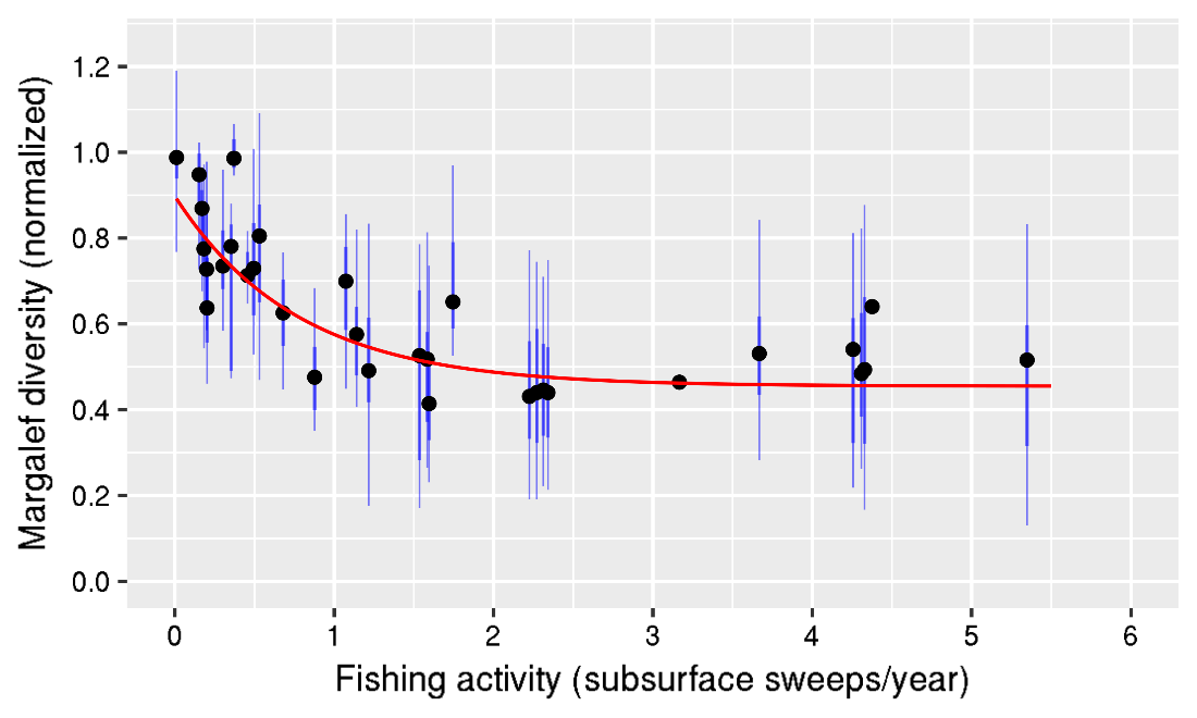
Figure 2. Relation between the fisheries pressure (subsurface) and the normalized Margalef diversity value, as demonstrated using all available benthos data in the Southern North Sea showing that the benthic community condition decreases (lower normalized Margalef index value) when the fisheries pressure increases.
The initial results show that the shallow coastal areas of Belgium, Germany, and the Netherlands, have a relatively lower condition compared to deeper offshore areas. Several UK areas showed a relatively high benthic condition, although the results have a low confidence as reference conditions for those offshore areas will need to be refined.
Trend Assessment
Unknown: The indicator was not considered as part of the 2012 Initial Assessment.
Conclusions
The UK target has not been applied due to data limitations within the Marine Strategy Framework Directive sub-region.
The selected diversity index assessed the benthic community quality for a range of assessment areas in the Southern North Sea and showed clear differences between different assessment areas. Coastal areas usually showed lower benthic quality.
This is the first time that a diversity index to assess changes in benthic communities has been applied on such a broad geographical scale. The UK target was not applied due to data limitations within the Marine Strategy Framework Directive sub-region, but it may apply to other UK regions in the next assessment cycle.
Knowledge gaps
The main knowledge gaps are:
- the lack of reference values for environmental variables needed to assess benthic community and habitat condition
- the influence of associated pressures such as nutrient enrichment, sedimentation, and heavy metals, particularly in offshore waters.
References
HM Government (2012) ‘Marine Strategy Part One: UK Initial Assessment and Good Environmental Status’ (viewed on 5 July 2018)
HM Government (2015) ‘Marine Strategy Part Three: UK Programme of Measures’ December 2015 (viewed on 5 July 2018)
OSPAR Commission (2017) ‘Intermediate Assessment 2017' Condition of Benthic Habitat Communities: Subtidal Habitats of the Southern North Sea’ (viewed on 16 January 2019)
Assessment Metadata
Please contact marinestrategy@defra.gov.uk for metadata information
Recommended reference for this indicator assessment
Phillips, G.1, McGruer, K.1, Crook, D.2, Doria, L.3, Herbon, C.3, Khan, J.4, Mackie, T.5, O’Reilly, M.4, Singleton, G.3 & Young, C.5 2018. Condition of soft sediment invertebrate communities in coastal waters determined using Water Framework Directive methods*. Marine Online Assessment Tool, available at: https://moat.cefas.co.uk/previous-assessments/2018-assessment/biodiversity-food-webs-and-marine-protected-areas/benthic-habitats/subtidal-habitats/
*Adapted from OSPAR Intermediate Assessment 2017 on Subtidal Habitats of the Southern North Sea
1Environment Agency
2Natural Resources Wales
3Joint Nature Conservation Committee
4Scottish Environment Protection Agency
5Department of Environment, Agriculture & Rural Affairs, Northern Ireland